
Cape Verde is a group of arid Atlantic islands which are home to a number of birds and reptiles and constitute a unique ecoregion in the World Wildlife Fund classification.

Santiago is the largest island of Cape Verde, its most important agricultural centre and home to half the nation’s population. Part of the Sotavento Islands, it lies between the islands of Maio and Fogo. It was the first of the islands to be settled: the town of Ribeira Grande was founded in 1462. Santiago is home to the nation's capital city of Praia.

Ponta do Sol is the northernmost city on the island of Santo Antão and Cape Verde. It is situated on the coast, 4 km northwest of Ribeira Grande and 20 km north of the island capital Porto Novo. It is the seat of Ribeira Grande municipality.

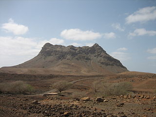
Monte Estância is a mountain in the southeastern part of the island Boa Vista in Cape Verde. At 387 m elevation, it is the island's highest point. It is located 4 km from the Atlantic coast and 23 km southeast of the island capital Sal Rei. It is part of a protected natural space under the statute of natural monument, which covers 739 ha.

Ilhéu de Sal Rei is an uninhabited islet near the coast of Boa Vista Island, Cape Verde. It is located 1 km southwest of the island capital Sal Rei. Its area is 89 ha (0.34 sq mi) and its highest point is 27 m (88.6 ft).

Fontainhas is a settlement in the northern part of the island of Santo Antão, Cape Verde. It is situated near the rocky north coast of the island, 2 km southwest of Ponta do Sol and 19 km north of the island capital Porto Novo. The settlement includes the smaller villages Corvo and Forminguinhas, about 1 km west of Fontainhas proper.

Praia de Chaves is a beach in the western part of the island of Boa Vista in Cape Verde, close to the town Rabil. It is about 5 km long.
Ponta do Sol is a headland located in the northwest of the island of Boa Vista. Cape Verde. It is the island's northernmost point. The town Sal Rei is approximately 6 km (3.7 mi) to the south, and the hill Vigia is 2 km (1.2 mi) to the south.

Fundo das Figueiras is a village in the eastern part of the island of Boa Vista. The village is around 21 km east of the island capital of Sal Rei. It is the seat of the civil parish of São João Baptista. 2 km to the south is the village Cabeça dos Tarrafes and 8 km southeast is Ponta Meringuel, the easternmost point in Cape Verde.

Ponta Varandinha is a headland and the westernmost point of the island of Boa Vista, Cape Verde. To its north lies the beach Praia da Varandinha. The nearest village is Povoação Velha, 5 km to the east. There is a lighthouse on the cape. Its focal height is 22 meters and its range extends to 10 nautical miles.

Morro Negro is a hill located near the east coast of the island of Boa Vista, Cape Verde. Its elevation is 156 m. The nearest village is Cabeça dos Tarrafes, 5.5 km to the northwest.
Cape Verde is a net importer of energy, with no significant fossil energy resources. As of 2016, 176,743 metric tonnes of fuel were sold on the internal market. Electricity production was 443 GWh in 2016, of which 81% from thermal power, 17% from wind power and 1.4% from solar power. The main electricity producing company of Cape Verde is Electra. Electra serves all islands of Cape Verde except Boa Vista, where electricity and water are produced and distributed by the public-private company Águas e Energia de Boavista. Other smaller electricity producers are Cabeólica, which operates 4 wind parks, Águas de Ponta Preta on the island of Sal, and Electric Wind on Santo Antão.
Rocha Estância is a mountain in the southwestern part of the island Boa Vista in Cape Verde, east of the village of Povoação Velha. Its elevation is 357 meters. It is part of a protected area covering 253 ha. The Our Lady of Conception church is located at the western foot of the mountain.

Monte Santo António is a mountain in the southwestern part of the island Boa Vista in Cape Verde. At 379 m (1,243 ft) elevation, it is the island's second highest point. Like Rocha Estância and Monte Estância, it rises steeply from the surrounding plains. It is part of a protected natural area under the statute of natural monument, covering 459 hectares.

Ervatão or Porto de Ervatão is a beach on the southeast coast of the island of Boa Vista in Cape Verde. At its eastern end is the headland Ponta de Ervatão. Ervatão is part of the Turtle Nature Reserve. The area of Ervatão receives 70% of all turtles nesting on Boa Vista. In July 2009, 8,000 turtle nests were counted.

Praia da Varandinha is a beach on the southwest coast of the island of Boa Vista in Cape Verde. It lies north of the headland Ponta Varandinha. The beach forms part of the protected area Morro de Areia Nature Reserve.
Monte Caçador and Pico Forcado Protected Countryside is a protected area covering 3,357 hectares (12.96 sq mi) of land in the eastern part of the island of Boa Vista in Cape Verde. It is the most important mountain formation on the island, but not the highest.

Praia de Carquejinha is a beach on the south coast of the island of Boa Vista in Cape Verde Neighboring beaches are Praia de Santa Mónica to the west and Praia de Curral Velho to the east. The beach is about 8 km long.


