Lobata is a district of São Tomé and Príncipe, on São Tomé Island. Its area is 105 km2 (41 sq mi), and its population is 19,365 (2012). The district seat is Guadalupe. It is divided into the four statistical subdistricts Guadalupe, Santo Amaro, Conde and Micoló.

Praia da Vitória, translated as the Beach of the Victory, is a municipality in the Portuguese archipelago of the Azores. With a population of 21,035, the second largest administrative authority on the island of Terceira, it covers an area of 161.27 square kilometres (62.27 sq mi), that extends from the northern coast halfway into the interior.

Sal Rei is a city on the northwestern coast of the island of Boa Vista in eastern Cape Verde. Sal Rei is the island's main urban settlement, and the seat of the Boa Vista Municipality. In 2010 its population was 5,778. The name of the settlement means "Salt King" in Portuguese. This name stems from when the island's main industry was salt production.

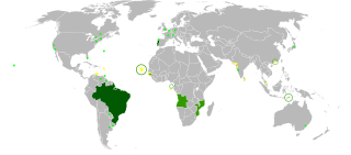
The Cape Verdean Football Federation is the governing body of football in Cape Verde. It was founded in 1982, affiliated to FIFA in 1986 and to CAF in 2000. It organizes the national football league and the national team.

Praia Grande is a large beach on the northeast coast of the island of São Vicente, Cape Verde. It is 1.5 km northwest of the village Calhau. The white sandy beach is surrounded by volcanic rocks. It is accessible by road from Calhau and Baía das Gatas.

Praia de Chaves is a beach in the western part of the island of Boa Vista in Cape Verde, close to the town Rabil. It is about 5 km long.
Praia de Santa Mónica is a sandy beach in the southwestern part of the island of Boa Vista in Cape Verde. The nearest village is Povoação Velha, 5 km to the north. The beach is adjacent to the protected area Morro de Areia Nature Reserve, which is important for endemic birds and turtles. Praia de Santa Mónica is part of a tourism development zone.

Praia de Atalanta is a beach on the north coast of the island of Boa Vista in Cape Verde. It is approximately 6 km northeast of the island capital of Sal Rei and 3 km west of Vigía. The wreck of the Spanish cargo ship Cabo Santa Maria, which ran aground on September 1, 1968, is located here.

The Deserto de Viana is a sand desert in the northwestern part of the island of Boa Vista, Cape Verde. It is situated east of the towns Rabil and Sal Rei, and west of Bofarreira. The desert itself is not a protected area, but it is adjacent to the nature reserve Boa Esperança, which includes the Lagoa do Rabil and the Praia de Atalanta.

Morro Negro is a hill located near the east coast of the island of Boa Vista, Cape Verde. Its elevation is 156 m. The nearest village is Cabeça dos Tarrafes, 5.5 km to the northwest.

Povoação Velha is a village in the southwestern part of the island of Boa Vista, Cape Verde. The village is around 16 km south of the island capital Sal Rei.

Praia de Cabral is a beach on the northwest coast of the island of Boa Vista in Cape Verde in the immediate area of the town of Sal Rei. Nearby in Praia de Fátima is an abandoned chapel of Our Lady of Fatima.

Ervatão or Porto de Ervatão is a beach on the southeast coast of the island of Boa Vista in Cape Verde. At its eastern end is the headland Ponta de Ervatão. Ervatão is part of the Turtle Nature Reserve. The area of Ervatão receives 70% of all turtles nesting on Boa Vista. In July 2009, 8,000 turtle nests were counted.

Praia da Varandinha is a beach on the southwest coast of the island of Boa Vista in Cape Verde. It lies north of the headland Ponta Varandinha. The beach forms part of the protected area Morro de Areia Nature Reserve.
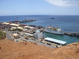
Praia Harbor is the port of the city of Praia in the southern part of the island of Santiago, Cape Verde. It is situated in a natural bay of the Atlantic Ocean. Since the latest modernization in 2014, it has 2 long quays, 3 shorter quays, a quay for fishing boats with fish processing installations, 2 container parks, 2 roll-on/roll-off ramps and a passenger terminal. The total length of the quays is 863 m, and the maximum depth is 13.5 m. The port of Praia played an important role in the colonization of Africa and South America by the Portuguese. With 817,845 metric tonnes of cargo and 85,518 passengers handled (2017), it is the second busiest port of Cape Verde, after Porto Grande (Mindelo).

Morro de Areia Nature Reserve is a nature reserve covering the southwestern coast of the island of Boa Vista in Cape Verde. It takes its name from the hill Morro de Areia, 167 m (548 ft) elevation. The natural reserve covers 21.31 km2 of land area, and stretches along the coast from the Praia de Chaves in the north to the Praia de Santa Monica in the south. The reserve includes a 300 m wide marine protection zone, an additional 4.36 km2.

Ilhéu dos Pásaros is a small uninhabited islet in the Cape Verde archipelago. It lies about 700 meters off the northeastern coast of the island of Boa Vista, near the beach Praia das Gatas. The area of the islet is 0.82 hectares (0.0032 sq mi)); with 38 ha of surrounding marine area it forms a protected area. It is a low, flat islet, covered with sedimentary material and sand. It is connected with the main island by a chain of reefs and volcanic rocks. It is an important nesting site for white-faced storm petrel and band-rumped storm petrel.

Praia de Carquejinha is a beach on the south coast of the island of Boa Vista in Cape Verde Neighboring beaches are Praia de Santa Mónica to the west and Praia de Curral Velho to the east. The beach is about 8 km long.