
Hydrology is the scientific study of the movement, distribution, and management of water on Earth and other planets, including the water cycle, water resources, and drainage basin sustainability. A practitioner of hydrology is called a hydrologist. Hydrologists are scientists studying earth or environmental science, civil or environmental engineering, and physical geography. Using various analytical methods and scientific techniques, they collect and analyze data to help solve water related problems such as environmental preservation, natural disasters, and water management.

Evapotranspiration (ET) is the combined processes which move water from the Earth's surface into the atmosphere. It covers both water evaporation and transpiration. Evapotranspiration is an important part of the local water cycle and climate, and measurement of it plays a key role in agricultural irrigation and water resource management.

In meteorology, precipitation is any product of the condensation of atmospheric water vapor that falls from clouds due to gravitational pull. The main forms of precipitation include drizzle, rain, sleet, snow, ice pellets, graupel and hail. Precipitation occurs when a portion of the atmosphere becomes saturated with water vapor, so that the water condenses and "precipitates" or falls. Thus, fog and mist are not precipitation but colloids, because the water vapor does not condense sufficiently to precipitate. Two processes, possibly acting together, can lead to air becoming saturated: cooling the air or adding water vapor to the air. Precipitation forms as smaller droplets coalesce via collision with other rain drops or ice crystals within a cloud. Short, intense periods of rain in scattered locations are called showers.
El Niño–Southern Oscillation (ENSO) is an irregular periodic variation in winds and sea surface temperatures over the tropical eastern Pacific Ocean, affecting the climate of much of the tropics and subtropics. The warming phase of the sea temperature is known as El Niño and the cooling phase as La Niña. The Southern Oscillation is the accompanying atmospheric component, coupled with the sea temperature change: El Niño is accompanied by high air surface pressure in the tropical western Pacific and La Niña with low air surface pressure there. The two periods last several months each and typically occur every few years with varying intensity per period.
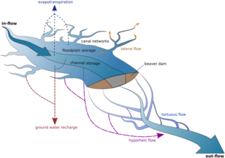
Ecohydrology is an interdisciplinary scientific field studying the interactions between water and ecological systems. It is considered a sub discipline of hydrology, with an ecological focus. These interactions may take place within water bodies, such as rivers and lakes, or on land, in forests, deserts, and other terrestrial ecosystems. Areas of research in ecohydrology include transpiration and plant water use, adaption of organisms to their water environment, influence of vegetation and benthic plants on stream flow and function, and feedbacks between ecological processes, the soil carbon sponge and the hydrological cycle.

Cluster II is a space mission of the European Space Agency, with NASA participation, to study the Earth's magnetosphere over the course of nearly two solar cycles. The mission is composed of four identical spacecraft flying in a tetrahedral formation. As a replacement for the original Cluster spacecraft which were lost in a launch failure in 1996, the four Cluster II spacecraft were successfully launched in pairs in July and August 2000 onboard two Soyuz-Fregat rockets from Baikonur, Kazakhstan. In February 2011, Cluster II celebrated 10 years of successful scientific operations in space. In February 2021, Cluster II celebrated 20 years of successful scientific operations in space. As of March 2023, its mission has been extended until September 2024. The China National Space Administration/ESA Double Star mission operated alongside Cluster II from 2004 to 2007.
In hydrology, moisture recycling or precipitation recycling refer to the process by which a portion of the precipitated water that evapotranspired from a given area contributes to the precipitation over the same area. Moisture recycling is thus a component of the hydrologic cycle. The ratio of the locally derived precipitation to total precipitation is known as the recycling ratio, ρ:

Earth's climate system is a complex system with five interacting components: the atmosphere (air), the hydrosphere (water), the cryosphere, the lithosphere and the biosphere. Climate is the statistical characterization of the climate system, representing the average weather, typically over a period of 30 years, and is determined by a combination of processes in the climate system, such as ocean currents and wind patterns. Circulation in the atmosphere and oceans is primarily driven by solar radiation and transports heat from the tropical regions to regions that receive less energy from the Sun. The water cycle also moves energy throughout the climate system. In addition, different chemical elements, necessary for life, are constantly recycled between the different components.

The Saharan Air Layer (SAL) is an extremely hot, dry and sometimes dust-laden layer of the atmosphere that often overlies the cooler, more-humid surface air of the Atlantic Ocean. It carries upwards of 60 million tonnes of dust annually over the ocean and the Americas. This annual phenomenon sometimes cools the ocean and suppresses Atlantic tropical cyclogenesis.
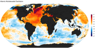
The Atlantic Multidecadal Oscillation (AMO), also known as Atlantic Multidecadal Variability (AMV), is the theorized variability of the sea surface temperature (SST) of the North Atlantic Ocean on the timescale of several decades.

The Indian Ocean Dipole (IOD), also known as the Indian Niño, is an irregular oscillation of sea surface temperatures in which the western Indian Ocean becomes alternately warmer and then colder than the eastern part of the ocean.

Pan evaporation is a measurement that combines or integrates the effects of several climate elements: temperature, humidity, rain fall, drought dispersion, solar radiation, and wind. Evaporation is greatest on hot, windy, dry, sunny days; and is greatly reduced when clouds block the sun and when air is cool, calm, and humid. Pan evaporation measurements enable farmers and ranchers to understand how much water their crops will need.

An atmospheric river (AR) is a narrow corridor or filament of concentrated moisture in the atmosphere. Other names for this phenomenon are tropical plume, tropical connection, moisture plume, water vapor surge, and cloud band.

During past ages, there was rain and snow on Mars; especially in the Noachian and early Hesperian epochs. Some moisture entered the ground and formed aquifers. That is, the water went into the ground, seeped down until it reached a formation that would not allow it to penetrate further. Water then accumulated forming a saturated layer. Deep aquifers may still exist.
PERSIANN, "Precipitation Estimation from Remotely Sensed Information using Artificial Neural Networks", is a satellite-based precipitation retrieval algorithm that provides near real-time rainfall information. The algorithm uses infrared (IR) satellite data from global geosynchronous satellites as the primary source of precipitation information. Precipitation from IR images is based on statistical relationship between cloud top temperature and precipitation rates. The IR-based precipitation estimates are then calibrated using satellite microwave data available from low Earth orbit satellites. The calibration technique relies on an adaptive training algorithm that updates the retrieval parameters when microwave observations become available.

The biotic pump is a theoretical concept that shows how forests create and control winds coming up from the ocean and in doing so bring water to the forests further inland.

Pacific Meridional Mode (PMM) is a climate mode in the North Pacific. In its positive state, it is characterized by the coupling of weaker trade winds in the northeast Pacific Ocean between Hawaii and Baja California with decreased evaporation over the ocean, thus increasing sea surface temperatures (SST); and the reverse during its negative state. This coupling develops during the winter months and spreads southwestward towards the equator and the central and western Pacific during spring, until it reaches the Intertropical Convergence Zone (ITCZ), which tends to shift north in response to a positive PMM.

The effects of climate change on the water cycle are profound and have been described as an intensification or a strengthening of the water cycle. This effect has been observed since at least 1980. One example is the intensification of heavy precipitation events. This has important negative effects on the availability of freshwater resources, as well as other water reservoirs such as oceans, ice sheets, atmosphere and land surface. The water cycle is essential to life on Earth and plays a large role in the global climate and the ocean circulation. The warming of our planet is expected to cause changes in the water cycle for various reasons. For example, warmer atmosphere can contain more water vapor which has effects on evaporation and rainfall.
Christa Peters-Lidard is an American hydrologist known for her work on integrating land surface modeling and data assimilation, particularly with remotely sensed measurements of precipitation.
Fixed anvil temperature hypothesis is a physical hypothesis that describes the response of cloud radiative properties to rising surface temperatures. It presumes that the temperature at which radiation is emitted by anvil clouds is constrained by radiative processes and thus does not change in response to surface warming. Since the amount of radiation emitted by clouds is a function of their temperature, it implies that it does not increase with surface warming and thus a warmer surface does not increase radiation emissions by cloud tops. The mechanism has been identified both in climate models and observations of cloud behaviour, it affects how much the world heats up for each extra tonne of greenhouse gas in the atmosphere. However, some evidence suggests that it may be more correctly formulated as decreased anvil warming rather than no anvil warming.
