Pierce County is a county in the U.S. state of Wisconsin. As of the 2020 census, the population was 42,212. Its county seat is Ellsworth.

Washington County is a county in the U.S. state of Minnesota. As of the 2020 census, the population was 267,568, making it the fifth-most populous county in Minnesota. Its county seat is Stillwater. The largest city in the county is Woodbury, the eighth-largest city in Minnesota and the fourth-largest Twin Cities suburb.

Hastings is a city mostly in Dakota County, Minnesota, of which it is the county seat, with a portion in Washington County, Minnesota, United States. It is near the confluence of the Mississippi, Vermillion, and St. Croix Rivers. The population was 22,154 at the 2020 census. It is named for the first elected governor of Minnesota, Henry Hastings Sibley.

The St. Croix River is a tributary of the Mississippi River, approximately 169 miles (272 km) long, in the U.S. states of Wisconsin and Minnesota. The lower 125 miles (201 km) of the river form the border between Wisconsin and Minnesota. The river is a National Scenic Riverway under the protection of the National Park Service. A hydroelectric plant at the Saint Croix Falls Dam supplies power to the Minneapolis–St. Paul metropolitan area.


The Aerial Lift Bridge, earlier known as the Aerial Bridge or Aerial Ferry Bridge, is a landmark in the port city of Duluth, Minnesota. The span began life in 1905 as the United States' first transporter bridge: Only one other was ever constructed in the country, Sky Ride in Chicago. The span was converted in 1929–1930 to a vertical-lift bridge, also rather uncommon, although there are six such bridges along Ontario's Welland Canal. It remains in operation. The bridge is owned and operated by the City of Duluth. The bridge was added to the National Register of Historic Places on May 22, 1973. The United States Army Corps of Engineers maintains a nearby maritime museum.

The Stillwater Bridge is a vertical-lift bridge crossing the St. Croix River between Stillwater, Minnesota, and Houlton, Wisconsin. It formerly connected Minnesota State Highway 36 and Wisconsin Highway 64. Around 18,000 vehicles crossed the bridge daily. The new St. Croix Crossing bridge crossing the St. Croix river valley to the south of Stillwater replaced its purpose, having opened to highway traffic on August 2, 2017, leaving the Stillwater Lift Bridge to be preserved and to be converted to bicycle/pedestrian use.

The Delair Bridge is a railroad bridge with a vertical-lift section that crosses the Delaware River between Philadelphia, Pennsylvania, and Pennsauken Township, New Jersey, just south of the Betsy Ross Bridge. The two-track bridge is part of Conrail Shared Assets Operations and is jointly used by Norfolk Southern Railway and CSX Transportation freight trains, as well as by the New Jersey Transit Atlantic City Line service.

The Saint Croix National Scenic Riverway is a federally protected system of riverways located in eastern Minnesota and northwestern Wisconsin. It protects 252 miles (406 km) of river, including the St. Croix River, and the Namekagon River, as well as adjacent land along the rivers. The St. Croix National Scenic Riverway is one of the original eight National Wild and Scenic Rivers, largely as a result of legislation by senators Walter Mondale of Minnesota and Gaylord Nelson of Wisconsin. The largest scenic riverway east of the Mississippi River, it lies within parts of eight counties in Wisconsin: Bayfield, Burnett, Douglas, Pierce, Polk, St. Croix, Sawyer, and Washburn; and three in Minnesota: Chisago, Pine, and Washington.

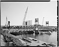
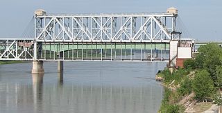
Hastings Rail Bridge is a vertical-lift bridge that spans the Mississippi River in Hastings, Minnesota. It is one of only four lift spans on the Mississippi River, the others being at Hannibal, Missouri, Burlington, Iowa and in downtown St. Paul, Minnesota. It was built in 1981 by Milwaukee Road and was designed by Howard, Needles, Tammen & Bergendoff.

State Trunk Highway 35 is a Wisconsin state highway running north–south across western Wisconsin. It is 412.15 miles in length, and is the longest state highway in Wisconsin. Portions of WIS 35 are part of the Great River Road.
The Armour-Swift-Burlington (ASB) Bridge, also known as the North Kansas City Bridge and the LRC Bridge, is a rail crossing over the Missouri River in Kansas City, Missouri, that formerly also had an upper deck for automobile traffic.

The Soo Line High Bridge, also known as the Arcola High Bridge, is a steel deck arch bridge over the St. Croix River between Stillwater, Minnesota and Somerset, Wisconsin, United States. It was designed by structural engineer C.A.P. Turner and built by the American Bridge Company from 1910 to 1911. The bridge was listed on the National Register of Historic Places in 1977 for its national significance in the themes of engineering and transportation. It was nominated for its exceptional dimensions, beauty, innovative engineering techniques, and importance to transportation between Minnesota and Wisconsin.
Point Douglas is a ghost town in section 8 of Denmark Township, Washington County, Minnesota, United States located at the convergence of the St. Croix River and the Mississippi River. It is located across the St Croix River from Prescott, Wisconsin.
The St. Croix Subdivision or St. Croix Sub is an American rail line operated by the BNSF Railway. It runs approximately 150 miles (240 km) from La Crosse, Wisconsin to Saint Paul, Minnesota, following the Mississippi River. It runs through the communities of La Crosse, Onalaska, Brice Prairie, Trempealeau, East Winona, Fountain City, Cochrane, Buffalo City, Alma, Nelson, Pepin, Stockholm, Maiden Rock, Bay City, Diamond Bluff, and Prescott, Wisconsin. This section of track sees 55-60 trains a day and is double tracked for most of the 150 miles with exceptions of Burns to Prescott, Mears to Trevino, and Winona Jct. to East Winona. The BNSF vertical lift bridge over the mouth of the St. Croix river is single-tracked.
Point Douglas to Superior Military Road, also known as Point Douglas to St. Louis River Military Road was a road that ran between Point Douglas, located at the outlet of the Lower St. Croix Lake near Hastings, Minnesota, first to the falls of the St. Louis River near Thomson, Minnesota, and later extended to the mouth of the St. Louis River in Superior, Wisconsin. From Douglas Point immediately east of Hastings, Minnesota, the route connected Stillwater, Taylors Falls, Sunrise, Chengwatana, Fortuna, Scotts Corner, to Thomson and Superior. Several discontinuous sections of this road are still in use.

The St. Francis River Bridge, also known as the Lake City Bridge, was a historic bridge spanning the St. Francis River at Lake City, Arkansas. It was composed of 109 I-beam trestles and a single vertical lift span, and had a total length of 3,412 feet (1,040 m). The bridge was designed and built in 1934 by the Vincennes Bridge Company, and carried Arkansas Highway 18 until 1998, when a modern 4-span I-beam bridge was built adjacent to it. The old bridge was dismantled, leaving only the vertical lift segment on the east bank of the river.

The St. Croix Crossing is an extradosed bridge that spans the St. Croix River, between Oak Park Heights, Minnesota and St. Joseph, Wisconsin. Connecting Minnesota State Highway 36 and Wisconsin State Highway 64, the bridge carries four lanes of traffic, and includes a bike/pedestrian path on the north side.
The Winona Rail Bridge was a swing bridge that spanned the Mississippi River between Winona, Minnesota, and Winona Junction in Buffalo, Buffalo County, Wisconsin. It was built to link the Winona and St. Peter Railroad with the La Crosse, Trempealeau & Prescott Railroad. Both became part of the Chicago and North Western Transportation Company (C&NW). The swing span was removed, but the box girder portion of the bridge still extends from Latsch Island just downstream of the current Main Channel Bridge. Piers from the original 1871 bridge and the box girders are in the North Channel just downstream of the current North Channel Bridge.