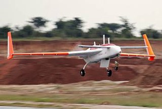
The AAI RQ-7 Shadow is an American unmanned aerial vehicle (UAV) used by the United States Army, Australian Army, Swedish Army, Turkish Air Force and Italian Army for reconnaissance, surveillance, and target acquisition and battle damage assessment. Launched from a trailer-mounted pneumatic catapult, it is recovered with the aid of arresting gear similar to jets on an aircraft carrier. Its gimbal-mounted, digitally stabilized, liquid nitrogen-cooled electro-optical/infrared (EO/IR) camera relays video in real time via a C-band line-of-sight data link to the ground control station (GCS).

Surveillance aircraft are aircraft used for surveillance. They are primarily operated by military forces and government agencies in roles including intelligence gathering, maritime patrol, battlefield and airspace surveillance, observation, and law enforcement.

An unmanned aerial vehicle (UAV), or unmanned aircraft system (UAS), commonly known as a drone, is an aircraft with no human pilot, crew, or passengers onboard. UAVs were originally developed through the twentieth century for military missions too "dull, dirty or dangerous" for humans, and by the twenty-first, they had become essential assets to most militaries. As control technologies improved and costs fell, their use expanded to many non-military applications. These include aerial photography, area coverage, precision agriculture, forest fire monitoring, river monitoring, environmental monitoring, weather observation, policing and surveillance, infrastructure inspections, smuggling, product deliveries, entertainment, and drone racing.

Aerial photography is the taking of photographs from an aircraft or other airborne platforms. When taking motion pictures, it is also known as aerial videography.

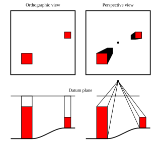
An orthophoto, orthophotograph, orthoimage or orthoimagery is an aerial photograph or satellite imagery geometrically corrected ("orthorectified") such that the scale is uniform: the photo or image follows a given map projection. Unlike an uncorrected aerial photograph, an orthophoto can be used to measure true distances, because it is an accurate representation of the Earth's surface, having been adjusted for topographic relief, lens distortion, and camera tilt.

Aerial survey is a method of collecting geomatics or other imagery data using airplanes, helicopters, UAVs, balloons, or other aerial methods. Typical data collected includes aerial photography, Lidar, remote sensing and geophysical data. It can also refer to a chart or map made by analyzing a region from the air. Aerial survey should be distinguished from satellite imagery technologies because of its better resolution, quality, and resistance to atmospheric conditions that can negatively impact and obscure satellite observation. Today, aerial survey is often recognized as a synonym for aerophotogrammetry, a part of photogrammetry where the camera is airborne. Measurements on aerial images are provided by photogrammetric technologies and methods.

AeroVironment, Inc. is an American defense contractor headquartered in Arlington, Virginia, that designs and manufactures unmanned aerial vehicles (UAVs). Paul B. MacCready Jr., a designer of human-powered aircraft, founded the company in 1971. The company is best known for its lightweight human-powered and solar-powered vehicles. The company is the US military's top supplier of small drones —notably the Raven, Switchblade, Wasp and Puma models.
The Denel Dynamics Seeker is an unmanned aerial vehicle (UAV) manufactured in South Africa by Denel Dynamics. The system is designed to perform tactical reconnaissance in real time and can conduct day and night surveillance in all threat environments.

Unmanned aerial vehicles (UAVs) include both autonomous drones and remotely piloted vehicles (RPVs). A UAV is capable of controlled, sustained level flight and is powered by a jet, reciprocating, or electric engine. In the twenty-first century, technology reached a point of sophistication that the UAV is now being given a greatly expanded role in many areas of aviation.

A miniature UAV, small UAV (SUAV), or drone is an unmanned aerial vehicle small enough to be man-portable. Smallest UAVs are called micro air vehicle.

The Qods Mohajer is an Iranian single-engine tactical unmanned aerial vehicle (UAV) built by the Qods Aviation Industry Company in four main variants from the 1980s to the present day. The Mohajer family is primarily used for reconnaissance, and is among the most mature and well-known Iranian UAVs.

The Environmental Research Aircraft and Sensor Technology, or ERAST program was a NASA program to develop cost-effective, slow-flying unmanned aerial vehicles (UAVs) that can perform long-duration science missions at altitudes above 60,000 ft (18,000 m). The project included a number of technology development programs conducted by the joint NASA-industry ERAST Alliance. The project was formally terminated in 2003.

The Northrop Grumman Bat is a medium-altitude unmanned air vehicle originally developed for use by the United States Armed Forces. Designed primarily as an intelligence "ISR" gathering tool, the Bat features 30 lb (14 kg) payload capacity and a 10 ft (3.0 m) wing span.

The DRDO Rustom is a family of medium-altitude long-endurance (MALE) unmanned air vehicle (UAV) being developed by the Defence Research and Development Organisation (DRDO) for the three services, Indian Army, Indian Navy and the Indian Air Force, of the Indian Armed Forces. Rustom is derived from the NAL's LCRA developed by a team under the leadership of late Professor Rustom Damania in the 1980s. The UAV will have structural changes and a new engine.

Aerial reconnaissance is reconnaissance for a military or strategic purpose that is conducted using reconnaissance aircraft. The role of reconnaissance can fulfil a variety of requirements including artillery spotting, the collection of imagery intelligence, and the observation of enemy maneuvers.

The AeroVironment T-20 unmanned aerial vehicle (UAV) is a medium range, composite aircraft capable of internal and external payloads. Launched from a portable catapult, it can be recovered with a shipboard landing system, or belly land on unimproved surfaces. The T-20 carries a retractable gimbal-mounted, digitally stabilized, electro-optical/infrared (EO/IR) camera that relays video in real time via a C-band LOS data link to the ground control station (GCS). Powered by a 4-stroke, fuel injected gasoline engine, the aircraft burns 2 lb (910 g) of fuel per hour at cruise. AeroVironment, Inc. acquired Arcturus UAV, the original developer of JUMP 20 and T-20 on February 22, 2021.
Lehmann Aviation Ltd (France), designs and manufactures professional civilian drones/UAVs since 2005. The company has two lines of UAVs: L-A series line of fully automatic drones designed for high precision mapping; construction/mining and precision agriculture; and L-M series line of both automatic and ground-controlled drones for long-range real-time surveillance.
PrecisionHawk was a commercial drone and data company. Founded in 2010, PrecisionHawk is headquartered in Raleigh, North Carolina with another global office in Toronto, Canada and satellite offices around the world. PrecisionHawk is a manufacturer of drones (Lancaster) and has more recently focused heavily on developing software for aerial data analysis (DataMapper) and drone safety systems (LATAS). PrecisionHawk is a member of the U.S. Federal Aviation Administration Pathfinder Initiative and the NASA UTM Program. An angel investor in the company, Bob Young, founder of Red Hat, became CEO in August 2015. In August 2016, PrecisionHawk became the first U.S. company to receive an FAA exemption to commercially fly drones beyond the operator's visual line of sight.

The Wing Loong-10 is a series of unmanned aerial vehicles of the High-Altitude Long Endurance (HALE) type, featuring some stealth characteristics. As of 2017, it is being developed by the Chengdu Aircraft Industry Group for reconnaissance and precision strike missions.

The TAI Aksungur is an unmanned combat aerial vehicle (UCAV) built by Turkish Aerospace Industries (TAI) for the Turkish Armed Forces. Using existing technology from the TAI Anka series of drones, it is the manufacturer's largest drone with payload capacity for mission-specific equipment. It is intended to be used for long-term surveillance, signals intelligence, maritime patrol missions, or as an unmanned combat aerial vehicle. TAI planned to integrate weapon packages and put the Aksungur into production in early 2020. The first unit was delivered to the Turkish Naval Forces on 20 October 2021.


