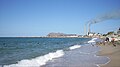
Puerto Libertad, Sonora

Last updated
Puerto Libertad
Mexico States blank map.svg
Red pog.svg
Puerto Libertad
Location in Sonora
Mexico Sonora location map.svg
Red pog.svg
Puerto Libertad
Puerto Libertad (Sonora)
Coordinates: 29°54′15″N112°40′59″W / 29.90417°N 112.68306°W / 29.90417; -112.68306
CountryFlag of Mexico.svg  Mexico
State Sonora
Municipality Pitiquito
Population
 (2010)
  Total2,782

Puerto Libertad is a town and port of the Mexican state of Sonora, Mexico. It is located on the north coast of the Gulf of California, in the municipality of Pitiquito.

Contents

Population

According to the results of the Census of Population and Housing 2005 Puerto Libertad population is 2,823 people, 1,489 of which are men and 1,334 women.

Economy

A place dedicated to fishing activities and also hosts one of the largest power plants in Mexico, operated by the Comisión Federal de Electricidad.

Because Puerto Libertad is home to a large, aged, heavy fuel burning power station operated by the national utility company, the town is the site of a proposed algal biofuel project which would produce ethanol. The system works on exhaust from the electric power plant. The two companies working on the project are an American Algenol technology and Mexican operator owner Biofields. Puerto Libertad is also the site of a solar energy project being developed by Sonora Energy Group Hermosillo, S.A. de C.V.

Puerto Libertad is located in the Sonoran Desert environment, which in conjunction with the sea, gives it a very special appeal, so it is increasingly attracting development of tourism.

Geography

Puerto Libertad is located at the geographic coordinates 29 ° 54'15 "N 112 ° 40'59" W / 29.90417, -112.68306, at an altitude of 10 meters above sea level, the distance that separates it from the capital state, the city of Hermosillo, is 416 kilometers and they are connected through the so-called coastal road.

Climate

Puerto Libertad has a desert climate (Köppen climate classification BWh).

Climate data for Puerto Libertad, Sonora (1981–2010, extremes (1960-present)
MonthJanFebMarAprMayJunJulAugSepOctNovDecYear
Record high °C (°F)29.0
(84.2)
32.0
(89.6)
33.5
(92.3)
41.0
(105.8)
42.0
(107.6)
44.0
(111.2)
43.0
(109.4)
44.0
(111.2)
44.0
(111.2)
42.0
(107.6)
38.0
(100.4)
32.2
(90.0)
44.0
(111.2)
Average high °C (°F)19.9
(67.8)
21.3
(70.3)
23.4
(74.1)
26.6
(79.9)
29.4
(84.9)
33.0
(91.4)
34.9
(94.8)
35.5
(95.9)
34.6
(94.3)
30.0
(86.0)
24.7
(76.5)
20.5
(68.9)
27.8
(82.0)
Daily mean °C (°F)13.5
(56.3)
14.8
(58.6)
17.0
(62.6)
20.0
(68.0)
22.9
(73.2)
27.1
(80.8)
30.6
(87.1)
31.1
(88.0)
29.4
(84.9)
23.8
(74.8)
18.1
(64.6)
14.1
(57.4)
21.9
(71.4)
Average low °C (°F)7.2
(45.0)
8.3
(46.9)
10.6
(51.1)
13.3
(55.9)
16.4
(61.5)
21.1
(70.0)
26.4
(79.5)
26.8
(80.2)
24.2
(75.6)
17.7
(63.9)
11.4
(52.5)
7.7
(45.9)
15.9
(60.6)
Record low °C (°F)−6.0
(21.2)
0.0
(32.0)
1.0
(33.8)
3.0
(37.4)
4.5
(40.1)
7.5
(45.5)
12.5
(54.5)
13.5
(56.3)
11.0
(51.8)
2.5
(36.5)
1.5
(34.7)
−1.0
(30.2)
−6.0
(21.2)
Average precipitation mm (inches)13.1
(0.52)
6.8
(0.27)
10.3
(0.41)
1.9
(0.07)
0.0
(0.0)
0.3
(0.01)
10.9
(0.43)
13.3
(0.52)
12.5
(0.49)
16.8
(0.66)
8.3
(0.33)
21.2
(0.83)
115.4
(4.54)
Average precipitation days (≥ 0.1 mm)2.31.31.20.50.00.21.71.81.31.31.32.515.4
Source: Servicio Meteorológico Nacional [1]

Related Research Articles

<span class="mw-page-title-main">Sonora</span> State of Mexico

Sonora, officially Estado Libre y Soberano de Sonora, is one of the 31 states which, along with Mexico City, comprise the Federal Entities of Mexico. The state is divided into 72 municipalities; the capital city of which being Hermosillo, located in the center of the state. Other large cities include Ciudad Obregón, Nogales, San Luis Río Colorado, and Navojoa.

<span class="mw-page-title-main">Hermosillo</span> City in Sonora, Mexico

Hermosillo, formerly called Pitic, is a city located in the center of the northwestern Mexican state of Sonora. It is the municipal seat of the Hermosillo municipality, the state's capital and largest city, as well as the primary economic center for the state and the region. As of 2020, the city has a population of 936,263, making it the 18th largest city in Mexico. The recent increase in the city's population is due to expanded industrialization, especially within the automotive industry.

<span class="mw-page-title-main">Heroica Nogales</span> City in Sonora, Mexico

Heroica Nogales, more commonly known as Nogales, is a city and the county seat of the Municipality of Nogales. It is located on the northern border of the Mexican state of Sonora. The city is abutted on its north by the city of Nogales, Arizona, across the U.S.-Mexico border.

<span class="mw-page-title-main">Sonoran Desert</span> Desert in northwestern Mexico and the southwestern United States

The Sonoran Desert is a desert in North America and ecoregion that covers the northwestern Mexican states of Sonora, Baja California, and Baja California Sur, as well as part of the southwestern United States. It is the hottest desert in both Mexico and the United States. It has an area of 260,000 square kilometers (100,000 sq mi).

<span class="mw-page-title-main">Puerto Peñasco</span> City in Sonora, Mexico

Puerto Peñasco is a small city located in Puerto Peñasco Municipality in the northwest of the Mexican state of Sonora, 100 kilometres (62 mi) from the border with the U.S. state of Arizona. According to the 2020 census, it has a population of 62,689 inhabitants. It is located on the northern shores of the Sea of Cortez on the small strip of land that joins the Baja California Peninsula with the rest of Mexico. The area is part of the Altar Desert, one of the driest and hottest areas of the larger Sonoran Desert.

<span class="mw-page-title-main">Sonoyta</span> Town in Sonora, Mexico

Sonoyta, Sonora is a town in the northern Mexican state of Sonora. It stands on the U.S.-Mexico border, facing Lukeville, Arizona, in the United States. It is the municipal seat of the municipality of Plutarco Elías Calles.

Empalme is a city surrounded by a municipality located on the south-central coast of the Mexican state of Sonora. According to the 2005 census the population of the city was 40,630 inhabitants, while the municipality, which has an area of 708.53 km², reported 50,663 inhabitants. Except for its coastline on the Gulf of California, the municipality is entirely surrounded by the much larger municipality of Guaymas.

<span class="mw-page-title-main">Bahía Kino</span> Town in Sonora, Mexico

Bahía Kino is a town part of the Hermosillo Municipality in Sonora, Mexico on the Gulf of California; it was named after Eusebio Kino. It has a population of approximately 7,000 people. The name also applies to the adjacent bay between Tiburón Island and Punta San Nicolás, Sonora. The names Bahía de Kino, Bahía Kino and Kino Bay are used interchangeably.

El Desemboque is a town located 376 km from Hermosillo on the shore of Gulf of California in the Mexican state of Sonora; coordinates N 29° 30' 13", W 112° 23' 43". It is part of the Municipality of Pitiquito, and is one of two major villages on the Seri Indian communal property, the other being Punta Chueca. The Spanish name refers to the fact that the Río San Ignacio meets the sea near that point. The Seri name is literally where the clams lie. It has been a good location to find the small clams Protothaca grata (haxöl). According to the Mexican census of 2010, the town had a population of 287 inhabitants. (The town of El Desemboque described in the prior text is not located in the Pitiquito municipality of Sonora. It is a Seri village about 120 km north of Punta Chueca north of Bahia Kino where the dry Rio Ignacio meets the Gulf of California. The El Desemboque in Pitiquito is west of Caborca at the mouth of Rio Concepcion and is a small village catering to weekenders from Caborca. The Seri may have lived at the El Desemboque west of present-day Caborca in prehistoric times before Spanish arrived as well as the current Seri town north of Bahia Kino. Their oral history has them living as far north as present day Puerto Penasco which was also an O'Odham settlement as well as present-day Bahia Kino and Isla Tiburon .)

<span class="mw-page-title-main">Baviácora</span>

Baviácora is a small town and the municipal seat of the surrounding municipality of the Mexican state of Sonora. The geographical coordinates are 29°42′N110°09′W.

<span class="mw-page-title-main">Caborca</span> City in Sonora, Mexico

Caborca is the municipal seat of the Caborca Municipality in the Mexican state of Sonora. The city has a population of 67,604, while the municipal population was 89,122 as of 2020.

<span class="mw-page-title-main">Pitiquito</span> Place in Sonora, Mexico

Pitiquito is a small town in Pitiquito Municipality in the northwest of the Mexican state of Sonora.

Rayón is a small town surrounded by its municipal area in the center of the Mexican state of Sonora at a distance of 110 kilometers from the state capital Hermosillo.

Yécora is a small town, and its surrounding municipality of the same name, in the Mexican state of Sonora, located at Latitude = 28.3710, Longitude = -108.9269 with an elevation of 5,173 feet. The town is bordered on the east by the state of Chihuahua, to the north by the municipalities of Sahuaripa and Southeast Rosario, to the west by the municipality Suaqui Grande, and the northwest by the municipality of Onavas. Yécora has an area of 1,279 square miles, accounting for 1.79 percent of total state. An approximate population for Yécora is 3171.

Hermosillo Stamping and Assembly is a Ford Motor Company-owned automobile assembly facility located in Hermosillo, Sonora, Mexico. The facility currently assembles Ford Bronco Sport and Ford Maverick (2022) models for the North American market. The facility, which began production in 1986, employs 1,500 people and covers a floor space of approximately 1,500,000 sq ft (140,000 m2).

<span class="mw-page-title-main">BioFields</span>

BioFields is a Mexican industrial group that produces biofuels from blue-green algae (cyanobacteria).

<span class="mw-page-title-main">Hermosillo Municipality</span> Municipality in Sonora, Mexico

Hermosillo is a municipality in Sonora in north-western Mexico. The municipal seat is the city of Hermosillo.

<span class="mw-page-title-main">Mexican ironwood carvings</span>

Mexican ironwood carving is a Mexican tradition of carving the wood of the Olneya tesota tree, a Sonora Desert tree commonly called ironwood.

<span class="mw-page-title-main">Solar power in Mexico</span> Overview of solar power in Mexico

Solar power in Mexico has the potential to produce vast amounts of energy. 70% of the country has an insolation of greater than 4.5 kWh/m2/day. Using 15% efficient photovoltaics, a square 25 km (16 mi) on each side in the state of Chihuahua or the Sonoran Desert could supply all of Mexico's electricity.

SEGH-CFE 1 is a photovoltaic project immediately adjacent to the Comisión Federal de Electricidad power station in Puerto Libertad, Sonora in Mexico, approximately 115 kilometres (71 mi) south of the United States border. The project is developed by Sonora Energy Group Hermosillo, S.A. de C.V., a privately owned company.

References

  1. "NORMALES CLIMATOLÓGICAS 1981-2010" (in Spanish). Servicio Meteorológico Nacional. Retrieved May 27, 2017.

29°55′N112°43′W / 29.917°N 112.717°W / 29.917; -112.717