
Montserrat is a multi-peaked mountain range near Barcelona, in Catalonia, Spain. It is part of the Catalan Pre-Coastal Range. The main peaks are Sant Jeroni, Montgrós and Miranda de les Agulles.

Valls is a city and municipality in the province of Tarragona in Catalonia, Spain. According to the 2014 census it has a population of 24,570.

The Volta a Catalunya is a road bicycle race held annually in Catalonia, Spain.
Tivissa is a municipality in the comarca of Ribera d'Ebre, Catalonia, Spain. It is located below the La Llena massif. As well as the village of Tivissa itself, the municipality also includes the village of La Serra d'Almos, at the feet of the Montalt mountains, and the hamlets of Darmós and Llaberia.

Cornellà de Llobregat is a municipality in the comarca of the Baix Llobregat in Catalonia, Spain. It is situated on the left bank of the Llobregat River. It is in the south-western part of the Barcelona metropolitan area and is part of the wider urban area. It houses one of the two La Liga football clubs from Catalonia, RCD Espanyol.

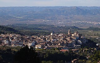
Òdena is a municipality in the comarca of the Anoia in Barcelona province, Catalonia, Spain. It is situated in the centre of the Òdena Basin, on the side of a small hill. The remains of Òdena castle with its octagonal tower are at the top of the hill. The town is served by the C-241 road from Igualada to Manresa, and the main N-II road from Barcelona to Lleida runs through the municipality.

Castellgalí is a municipality in the comarca of the Bages in Catalonia, Spain. It is situated at the confluence of the Llobregat River and the Cardener River. The railway station serves both the FGC line R5 between Barcelona and Manresa and the RENFE line between Barcelona and Zaragoza.

Cantallops is a municipality in the comarca of the Alt Empordà in Girona, Catalonia, Spain. It is situated below the Albera Range, and is linked to La Jonquera by the GI-601 road.

Calonge is a municipality in the comarca of the Baix Empordà in Catalonia, Spain, on the coastline of the Costa Brava.
Centelles is a municipality in the comarca of Osona in Catalonia, Spain. It is situated in the upper valley of the Congost River in the south of the comarca. The municipality is served by the C-17 road. The renowned urban planner Ildefons Cerdà was born here.

Porqueres is a municipality located in the county of Pla de l'Estany, in the province of Girona, in the autonomous region of Catalunya of Spain. The municipality is made up of several villages. Mata, Les Pedreres and Miànigues, have the largest part of the population. At the top of the mountain range of Serra de Sant Patllari is the village of Pujarnol. In the west is Porqueres, and on the northern part of the Lake of Banyoles is Usall. Amid the green forests of the Ginestar mountains is the village of Merlant.

La Fatarella is a municipality in northern Terra Alta, within the region of Ribera d'Ebre in Spain.

The following outline is provided as an overview of and topical guide to Catalonia:

Mont Caro or Caro is the highest mountain of the Ports de Tortosa-Beseit, Catalonia, Spain.

Tossal dels Tres Reis or Tossal del Rei is a mountain of the Ports de Tortosa-Beseit massif, Spain. It has an elevation of 1,350 metres above sea level.

Mare de Déu del Mont, also known as Serra del Mont, is a mountain range of the Alta Garrotxa natural region, Catalonia, Spain. It has an elevation of 1,123 metres above sea level.

Catalunya en Miniatura is miniature park inaugurated in 1983 in Torrelles de Llobregat, 17 km from Barcelona. The park is 60,000 square meters, 35,000 of them devoted to the scale models, it is one of the largest miniature parks in the world, and the largest of the 14 miniature building exhibitions present in Europe. It displays 147 models of palaces, churches, bridges and other buildings from Catalonia and Mallorca and it includes all the major works by the renowned architect Antoni Gaudí.

Montmeneu or Punta de Montmaneu is a mountain in Catalonia, Spain. It is located within the La Granja d'Escarp and Seròs municipal limits, Segrià.
Sant Salvador de Breda is a parish church and former Benedictine monastery in Breda, Province of Girona, Catalonia, Spain.
