La Seu d'Urgell is a town located in Alt Urgell county in Alt Pirineu, Catalonia, Spain. The town is also the head of its judicial district and the seat of the Bishop of Urgell, one of the co-princes of Andorra. It is located the most populated town of the region, with 17.4% of its population. La Seu d'Urgell and Puigcerdà together have 30% of the population of the area.

Besalú is a town in the comarca of Garrotxa, in Girona, Catalonia, Spain.

Sant Adrià de Besòs is a city and a municipality within the comarca of Barcelonès in Catalonia, north-eastern Spain. It is situated on the Mediterranean coast, at the mouth of river Besòs, extending to both sides of the estuary although the original settlement with the parish church lies on the left bank of the river, in the northern part of town. Sant Adrià is the smallest municipality of Barcelonès and has close ties with the neighbouring cities of Barcelona, Badalona and Santa Coloma de Gramenet, forming a uniform urban area within Barcelona metropolitan area.

La Vall de Boí is a municipality and narrow, steep-sided valley in Catalonia. It lies in the Alta Ribagorça county in the Alt Pirineu region, on the edges of the Pyrenees. In 2022, it had a population of 1,090.

Sant Sadurní d'Anoia is a municipality in the comarca of the Alt Penedès in Catalonia, Spain; and the centre of production of a sparkling wine known as cava. It is situated in the north-east of the Penedès Depression at the confluence of the Avernó river and the Anoia river. It is accessible by the AP-7 autopista and the Renfe railway line (R4) that connect Barcelona with Manresa and El Vendrell.

Rubí is a municipality in Catalonia (Spain), in the comarca of Vallès Occidental and the province of Barcelona, 15 kilometers from Barcelona. It is bordered on the north by Terrassa and Ullastrell, on the south by Sant Cugat del Vallès, on the west by Castellbisbal and on the east by Sant Quirze del Vallès.

Passeig de Sant Joan is a major avenue in the Eixample and Gràcia districts of Barcelona. It was named after an older street carrying this name, also known as Passeig Nou, built in 1795 around the glacis of the Ciutadella fortress.
Saint-Genis-Pouilly is a commune in the Ain department within the Auvergne-Rhône-Alpes region of eastern France.

Vall d'Hebron | Sant Genis is a Barcelona Metro station, in the Horta-Guinardó district of Barcelona, and named after the nearby Vall d'Hebron neighbourhood. The station is served by line L3 and is the northern terminus of line L5.
Saint-Génis-des-Fontaines is a commune in the Pyrénées-Orientales department in southern France.

Torà is a town and municipality in the North East of the comarca (county) of Solsonès, in the province of Lleida, Catalonia, Spain. The urban structure of the center has retained most of its original design, with narrow, twisting streets and blocks formed by rows of attached buildings. The Medieval town grew around a castle or fortified place. A particular trait of the fortified origin of the town is the presence of a number of portals to allow several streets their pass through defensive barriers formed by the rows of buildings of the town and its walls. Torà is some 10 kilometers northeast from the more populated Guissona, a neighbor town that has experienced an important economic development in the last half century parallel to an unprecedented demographic growth sped up in the recent years.

Amer is a municipality in the comarca of la Selva in the province of Girona, Catalonia, Spain.

Cruïlles, Monells i Sant Sadurní de l'Heura is a Spanish municipality of the Province of Girona, situated in the comarca (county) of Baix Empordà (Catalonia), formed in 1973 by merging the municipalities of Cruïlles, Monells, and Sant Sadurní de l'Heura. Sant Sadurní is the capital of the municipality. According to the 2014 census, the municipality has a population of 1,284 inhabitants.
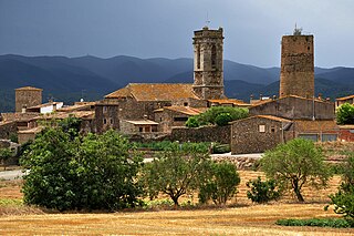
Cruïlles is a village in the Baix Empordà, now part of the municipality of Cruïlles, Monells i Sant Sadurní de l'Heura, which is the administrative center and location of City Hall. It was its own municipality until 1973, when it merged with Monells and Sant Sadurní de l'Heura to form the current municipality.

The Plaça de Sant Jaume is a square at the center of the Old City of Barcelona and the administrative heart of both the city and surrounding Catalonia. This is because the Palace of the Generalitat of Catalonia and the City Hall are located here across from one another.

Sant Miquel de Cruïlles is a Benedictine monastery in Cruïlles, Monells i Sant Sadurní de l'Heura, Catalonia, Spain. The 11th-century building, in First Romanesque style, was declared a Bien de Interés Cultural landmark in 1931.
Sant Sadurní may refer to:
Sant Miquel may refer to:

Plaça de Sant Felip Neri is a small square in the Gothic Quarter in the district of Ciutat Vella in Barcelona, Catalonia, Spain. The square takes its name from the Church of Saint Philip Neri, which presides over the square. To the right of the church is the School of Saint Felip Neri which uses the square as a playground. To the left of the church is a house used by the Oratory of Saint Philip Neri. In the centre of the square is an octagonal fountain, dedicated as a symbol of life. The architecture surrounding the square includes buildings of Renaissance and Baroque style.
Ingobert was a bishop of Urgell and co-Prince of Andorra.