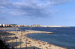
Palamós is a town and municipality in the Mediterranean Costa Brava, located in the comarca of Baix Empordà, in the province of Girona, Catalonia, Spain. Palamós is located at the northern end of a large bay. The town is by-passed by the C31 which connects the coastal towns of the central Costa Brava with Girona. Palafrugell lies 8.5 kilometres (5.3 mi) to the north and Castell-Platja d'Aro 7 kilometres (4.3 mi) to the south.

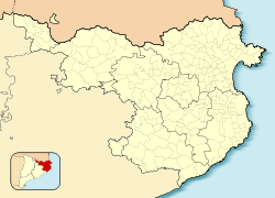
Baix Empordà is a comarca (county) in the Girona region, Catalonia, in Spain. It is one of the two comarques into which Empordà was divided in the comarcal division of 1936, the other one being Alt Empordà. It is popularly known as L'Empordanet. The capital is La Bisbal d'Empordà.

The Costa Brava is a coastal region of Catalonia in northeastern Spain. Sources differ on the exact definition of the Costa Brava. Usually it can be regarded as stretching from the town of Blanes, 60 km (37 mi) northeast of Barcelona, to the French border – in other words it consists of the coast of the province of Girona.
Palafrugell is a municipality in the Mediterranean Costa Brava, located near Palamós in the comarca of Baix Empordà, in the province of Girona, Catalonia, Spain. It is the largest city of its comarca, with 22,365 inhabitants. Several coastal and interior towns are frequently grouped with this city.

The Cala d'Aiguablava is a small bay on the Costa Brava, Girona, Catalonia (Spain) near Begur and Palafrugell with a small beach and a few mainly seafood restaurants. It is a popular mooring place for sailing and motor boats. Overlooking the bay on one side is a large parador, the Parador De Aiguablava, situated high on a clifftop.
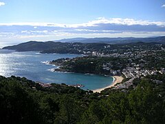
Tamariu is one of three coastal towns belonging to the municipality of Palafrugell, province of Girona, Spain, the other two being Calella de Palafrugell and Llafranc. It is part of the Costa Brava, the coastal region of northeastern Catalonia, in the comarca of Baix Empordà. It is situated about 70 mi (110 km) south of the border with France and close to the nearby inland towns of Palafrugell and Begur.

Cassà de la Selva is a municipality in the comarca of the Gironès in Catalonia, It is linked to Girona and to the Baix Empordà by the C-65 road. During the 20th century it was known for the production of cork and derived articles. With an increasing population of 9,200 citizens, this municipality is located 12 km south of Girona and 20 km west of the Mediterranean Sea.

Sant Feliu de Guíxols is a municipality in the comarca of the Baix Empordà in Catalonia, Spain. It is situated on the Costa Brava and is an important port and tourist centre. The district abuts to the north, the upmarket s'Agaró resort built round the Sant Pol Beach. In addition to tourism and the port the cork industry is a traditionally local industry. The town contains a large monastery which now houses the town museum and is a protected historico-artistic monument.
Begur is a village and municipality in the comarca of Baix Empordà and province of Girona in Catalonia, Spain. The village itself lies some 2 kilometres (1.2 mi) from, and 200 metres (660 ft) above, the coastline of the Costa Brava, but the municipality includes several seaside resorts.

Castell d'Aro, Platja d'Aroi S'Agaró is a municipality in the middle of the Costa Brava in Catalonia, Spain. It is formed from two parts: Castell d'Aro is an ancient village built around a medieval castle and a fortified church, 3 km inland on the road from Platja d'Aro to Santa Cristina d'Aro; and Platja d'Aro is a coastal town on the road from Palamós to Sant Feliu de Guíxols which stretches along a large 2 km beach. generally Castell-Platja d'Aro's population is about 12,000 but can exceed 100,000 in summer months.

Pals is a medieval town in Catalonia, northern Spain, a few kilometres from the sea in the heart of the Bay of Emporda on the Costa Brava. It lies on the C31 Palafrugell–L'Estartit road.

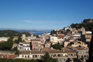
Mont-ras is a village and rural district situated between the larger towns of Palafrugell and Palamos on the Costa Brava in Baix Emporda, in the province of Girona, Catalonia, Spain. Mont-ras is approximately 40 minutes from Girona, or 80 minutes from Barcelona.
S'Agaró is an upmarket resort on the Costa Brava between Sant Feliu de Guíxols and Platja d'Aro. It is part of the municipality of Castell-Platja d'Aro, itself in the comarca of Baix Empordà and province of Girona in Catalonia, Spain. The resort was developed from the early 1920s on the peninsular between the beaches of Platja de Sant Pol and Platja de Sa Conca.

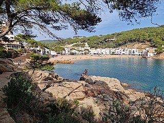
Fornells de Mar, also known as Platja de Fornells or simply Fornells, is a village, bay and port on the Costa Brava and in the municipality of Begur, Catalonia, Spain. It lies between Sa Tuna and Tamariu. It was formerly mainly a fishing village and there is still some fishing activity.
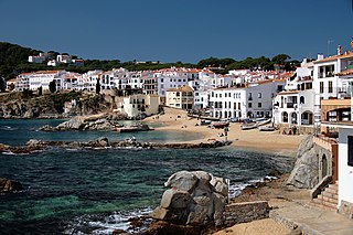
Calella de Palafrugell is one of three coastal towns belonging to the municipality of Palafrugell in the province of Girona, Spain. The other two towns are Llafranc, only one kilometre (0.62 mi) to the north, and Tamariu, some four kilometres (2.5 mi) to the north. All three towns are part of the Costa Brava, the coastal region of northeastern Catalonia, in the comarca of Baix Empordà. It should not be confused with the larger, more commercialised resort of Calella, which is further south towards Barcelona, in the comarca of Maresme.
Sant Sebastià de la Guarda is a historical site located in the town of Llafranc in the Baix Emporda region of Girona province. The site consists of an Iberian archeological site from the 6th-1st centuries B.C., a 15th-century watchtower and a 19th-century lighthouse on top of a small mountain 156m above the sea, which protected the region from pirate attacks and retains many of its original features.
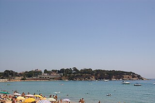
Sant Antoni de Calonge is a town which forms part of the city of Calonge. It is located in the comarca of the Baix Empordà in Catalonia, Spain. The town was built along the rocky coastline of northern Spain. There is a seaside promenade that connects many neighboring towns. Sant Antoni de Calonge is between Platja d'Aro and Palamós.

La Fosca is a neighbourhood of the town of Palamós and a beach on the Costa Brava, located in the comarca of Baix Empordà and the province of Girona in Catalonia, Spain. La Fosca is situated between the port of Palamós and the fishing settlement of S'Alguer. The town is by-passed by the C31 which connects the coastal towns of the central Costa Brava with Girona. Palafrugell lies 8.5 kilometres (5.3 mi) to the north and Castell-Platja d'Aro 7 kilometres (4.3 mi) to the south.

The Cork Museum of Palafrugell, Spain, is a museum about the cork industry in Catalonia. Founded in 1972, the Cork Museum is part of the Costa Brava Museum Network and the Network of Local Museums of Catalonia in Girona.
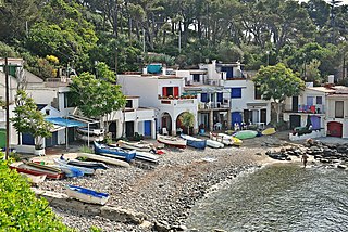
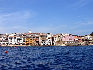
The Cala s'Alguer is a traditional fishing village on the Costa Brava coast of Catalonia, Spain. It is part of the municipality of Palamós, in the comarca of Baix Empordà and the province of Girona. The historical complex has been declared a cultural asset of national interest.