Calella de Palafrugell

Last updated • 3 min readFrom Wikipedia, The Free Encyclopedia
Calella de Palafrugell
Town
Calella de Palafrugell (26023087965).jpg
Calella de Palafrugell
Gerona-loc.svg
Red pog.svg
Catalonia location map.svg
Red pog.svg
Spain location map with provinces.svg
Red pog.svg
Coordinates: 41°53′16″N3°11′00″E / 41.88778°N 3.18333°E / 41.88778; 3.18333 Coordinates: 41°53′16″N3°11′00″E / 41.88778°N 3.18333°E / 41.88778; 3.18333
CountryFlag of Spain.svg  Spain
Autonomous community
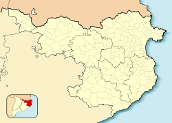
 Flag of Catalonia.svg  Catalonia
Province Girona
Comarca Baix Empordà
Municipality Palafrugell
Elevation
0 m (0 ft)
Time zone UTC+1 (CET)
  Summer (DST) UTC+2 (CEST)

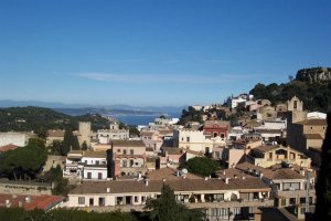
Calella de Palafrugell is one of three coastal towns belonging to the municipality of Palafrugell in the province of Girona, Spain. The other two towns are Llafranc, only one kilometre (0.62 mi) to the north, and Tamariu, some four kilometres (2.5 mi) to the north. All three towns are part of the Costa Brava, the coastal region of northeastern Catalonia, in the comarca of Baix Empordà. It should not be confused with the larger, more commercialised resort of Calella, which is further south towards Barcelona, in the comarca of Maresme. [1]

Contents

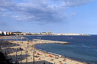
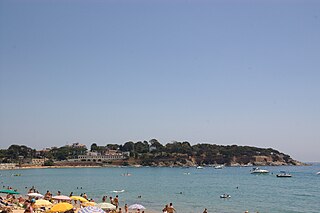
Calella de Palafrugell has an excellent setting and, whilst busy in the summer season, it does not have the large hotels and mass tourism of other Costa Brava resorts such as Lloret de Mar. The town has a number of good standard hotels, apartments and, at a distance from the beach, some campsites. Like much of the picturesque section of the Costa Brava, north of Palamos and south of L'Estartit, Calella has moved steadily upmarket in recent times and offers some very high quality restaurants and hotels - at prices to match. The beaches are Blue Flag standard. Calella de Palafrugell is a very popular destination dominated by apartments blocks set just back enough not to be seen from the beach.[ citation needed ]

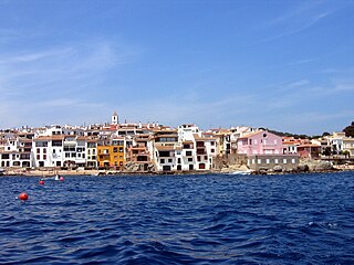
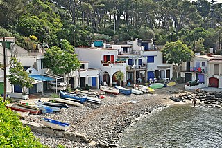
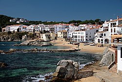
The town's origin is that of a fishing village, and its old maritime quarter, the Port Bo  [ ca ] has been declared a cultural asset of national importance. This quarter retains the original layout of the village, with its traditional white porched buildings. It includes the complex of vaults, originally used to sew nets and auction fish, but now occupied by restaurants. The vaults are fronted by the beaches of Platja del Port de Malaspina and Platja de Portbò, which formed a natural fishing port and are still home to a fleet of small fishing boats. Also in Port Bo is the Sa Perola Interpretation Centre, housed in a former net dyeing house and now used as a tourist office and interpretation centre for the fishing industry and maritime heritage of the district. [2]

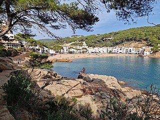
Calella de Palafrugell has a number of small coves and beaches linked via a well engineered coastal walk known as the Cami de Ronda, passing along the cliffs and through several tunnels on the way. From the north the first of the beaches is Platja del Canadell, with its beach restaurant. Platja del Port de Malaspina, Platja de Portbò and Platja d'en Calau are linked sandy coves located in the centre of Calella. These are followed by Platgeta d'en Cosme, Platje de Port Pelegri, Platja de Sant Roc and Platja del Golfet, the last of which is approximately 1.5 kilometres (0.93 mi) from central Calella. [1] [3] [4]

Beyond Platja del Golfet is the Cap Roig headland, where the Castell de Cap Roig  [ ca ] is situated, surrounded by large botanical gardens. The castle has also been declared a cultural asset of national importance. The castle was built, and the gardens created, between 1929 and 1975, by Nicholas Woevodski and Dorothy Webster. The Cap Roig Festival, a music and dance festival, is held in the gardens between July and August. [1] [5] [6]

The GR 92 long-distance footpath, which runs the length of the Mediterranean coast of Spain, passes along the Cami de Ronda. To the north of Platja del Canadell the path follows the coast the short distance to Llafranc, passing the 16th century Torre de Calella  [ ca ] on the way. To the south the path takes an inland route from Platja del Golfet, bypassing Cap Roig through pine and cork oak forests to the fisherman's village at S'Alguer  [ ca ] and the beach at La Fosca. [1]

Related Research Articles

<span class="mw-page-title-main">Palamós</span> Municipality in Catalonia, Spain

Palamós is a town and municipality in the Mediterranean Costa Brava, located in the comarca of Baix Empordà, in the province of Girona, Catalonia, Spain. Palamós is located at the northern end of a large bay. The town is by-passed by the C31 which connects the coastal towns of the central Costa Brava with Girona. Palafrugell lies 8.5 kilometres (5.3 mi) to the north and Castell-Platja d'Aro 7 kilometres (4.3 mi) to the south.

<span class="mw-page-title-main">Baix Empordà</span> Comarca in Catalonia, Spain

Baix Empordà in Catalan or Bajo Ampurdán in Spanish is a comarca (county) in the province of Girona, Catalonia, Spain. It is one of the two comarca into which Empordà was divided in the comarcal division of 1936, the other one being Alt Empordà. It is popularly known as L'Empordanet.

<span class="mw-page-title-main">Costa Brava</span> Coastal region of Catalonia, Spain

The Costa Brava is a coastal region of Catalonia in northeastern Spain. Whilst sources differ on the exact definition of the Costa Brava, it can be regarded as stretching from the town of Blanes, 60 km (37 mi) northeast of Barcelona, to the French border, and thus includes the coastal parts of the province of Girona.

<span class="mw-page-title-main">L'Escala</span> Municipality in Catalonia, Spain

L'Escala is a municipality in the comarca of the Alt Empordà in Girona, Catalonia, Spain. It is situated on the Costa Brava, located between the southern end of the Gulf of Roses and Cala (bay) Montgó. It is an important fishing port and tourist centre, and has a festival dedicated to its famous anchovies. The GE-513 road runs inland from the town.

<span class="mw-page-title-main">Palafrugell</span> Municipality in Catalonia, Spain

Palafrugell is a municipality in the Mediterranean Costa Brava, located near Palamós in the comarca of Baix Empordà, in the province of Girona, Catalonia, Spain. With 22,365 inhabitants it is the largest city of its comarca. Several coastal and interior towns belong to this city.

<span class="mw-page-title-main">Llafranc</span> Town in Catalonia, Spain

Llafranc is one of three coastal towns belonging to the municipality of Palafrugell, province of Girona, Spain, the other two being Calella de Palafrugell and Tamariu. It is part of the Costa Brava, the coastal region of northeastern Catalonia, in the comarca of Baix Empordà.

<span class="mw-page-title-main">Tamariu</span> Town in Catalonia, Spain

Tamariu is one of three coastal towns belonging to the municipality of Palafrugell, province of Girona, Spain, the other two being Calella de Palafrugell and Llafranc. It is part of the Costa Brava, the coastal region of northeastern Catalonia, in the comarca of Baix Empordà. It is situated about 70 mi (110 km) south of the border with France and close to the nearby inland towns of Palafrugell and Begur.

<span class="mw-page-title-main">La Bisbal d'Empordà</span> Municipality in Catalonia, Spain

La Bisbal d'Empordà is the county seat of the comarca of Baix Empordà in Catalonia, Spain. The town lies 29 km southeast of Girona, 12 km west of Palafrugell and 19 km northwest of Palamós along road C-66 from Girona to Palafrugell/Palamós, where it becomes C-31. Two other roads branch off at La Bisbal, GI-660 to Calonge and Sant Feliu de Guíxols and GI-664 to Cassà de la Selva; both roads cross the hilly coastal range called the Gavarres, with many twists and turns. The municipality lies on the northern edge of the Gavarres, on either side of the Daró river-bed, a dry tributary of River Ter.

<span class="mw-page-title-main">Cassà de la Selva</span> Municipality in Catalonia, Spain

Cassà de la Selva is a municipality in the comarca of the Gironès in Catalonia, It is linked to Girona and to the Baix Empordà by the C-65 road. During the 20th century it was known for the production of cork and derived articles. With an increasing population of 9,200 citizens, this municipality is located 12 km south of Girona and 20 km west of the Mediterranean Sea.

<span class="mw-page-title-main">Sant Feliu de Guíxols</span> Municipality in Catalonia, Spain

Sant Feliu de Guíxols is a municipality in the comarca of the Baix Empordà in Catalonia, Spain. It is situated on the Costa Brava and is an important port and tourist centre. The district abuts to the north, the upmarket s'Agaró resort built round the Sant Pol Beach. In addition to tourism and the port the cork industry is a traditionally local industry. The town contains a large monastery which now houses the town museum and is a protected historico-artistic monument.

<span class="mw-page-title-main">Begur, Spain</span> Municipality in Catalonia, Spain

Begur is a village and municipality in the comarca of Baix Empordà and province of Girona in Catalonia, Spain. The village itself lies some 2 kilometres (1.2 mi) from, and 200 metres (660 ft) above, the coastline of the Costa Brava, but the municipality includes several seaside resorts.

<span class="mw-page-title-main">Castell-Platja d'Aro</span> Municipality in Catalonia, Spain

Castell d'Aro, Platja d'Aroi S'Agaró is a municipality in the middle of the Costa Brava in Catalonia, Spain. It is formed from two parts: Castell d'Aro is an ancient village built around a medieval castle and a fortified church, 3 km inland on the road from Platja d'Aro to Santa Cristina d'Aro; and Platja d'Aro is a coastal town on the road from Palamós to Sant Feliu de Guíxols which stretches along a large 2 km beach.

<span class="mw-page-title-main">Pals</span> Municipality in Catalonia, Spain

Pals is a medieval town in Catalonia, northern Spain, a few kilometres from the sea in the heart of the Bay of Emporda on the Costa Brava. It lies on the C31 Palafrugell–L'Estartit road.

<span class="mw-page-title-main">Mont-ras</span> Municipality in Catalonia, Spain

Mont-Ras is a village and rural district situated between the larger towns of Palafrugell and Palamos on the Costa Brava in Baix Emporda, in the province of Girona, Catalonia, Spain. Mont-ras is approximately 40 minutes from Girona, or 80 minutes from Barcelona.

<span class="mw-page-title-main">S'Agaró</span> Neighbourhood in Girona, Catalonia, Spain

S'Agaró is an upmarket resort on the Costa Brava between Sant Feliu de Guíxols and Platja d'Aro. It is part of the municipality of Castell-Platja d'Aro, itself in the comarca of Baix Empordà and province of Girona in Catalonia, Spain. The resort was developed from the early 1920s on the peninsular between the beaches of Platja de Sant Pol and Platja de Sa Conca.

<span class="mw-page-title-main">C-31 highway (Spain)</span>

C-31 or Eix Costaner is one of Catalonia's primary highways. It is the result of merging several sections of previously existing roads, autopistas and autovías after the 2004's renaming of primary highways managed by the Generalitat de Catalunya. According to this new denomination, the first number (C-31) indicates that is a southwest-northeast highway, while the second number (C-31) indicates that is the closest to the Mediterranean Sea.

<span class="mw-page-title-main">Fornells de Mar</span> Village, bay and port in the municipality of Begur, Catalonia, Spain

Fornells de Mar, also known as Platja de Fornells or simply Fornells, is a village, bay and port on the Costa Brava and in the municipality of Begur, Catalonia, Spain. It lies between Sa Tuna and Tamariu. It was formerly mainly a fishing village and there is still some fishing activity.

<span class="mw-page-title-main">Mont-roig del Camp</span> Municipality in Catalonia, Spain

Mont-roig del Camp is a town and municipality in the comarca of Baix Camp in Catalonia. It is in the middle of its comarca, between the Serra de Colldejou and the Mediterranean Sea. It includes two populated places: the historic town of Mont-roig del Camp in the interior, whose economy revolves round the cultivation of nuts and olives, and the beach resort of Miami Platja on the coast, the Costa Daurada.

<span class="mw-page-title-main">La Fosca</span> Neighbourhood in Girona, Catalonia, Spain

La Fosca is a neighbourhood of the town of Palamós and a beach on the Costa Brava, located in the comarca of Baix Empordà and the province of Girona in Catalonia, Spain. La Fosca is situated between the port of Palamós and the fishing settlement of S'Alguer. The town is by-passed by the C31 which connects the coastal towns of the central Costa Brava with Girona. Palafrugell lies 8.5 kilometres (5.3 mi) to the north and Castell-Platja d'Aro 7 kilometres (4.3 mi) to the south.

<span class="mw-page-title-main">Cala s'Alguer</span> Fishing village in Catalonia, Spain

The Cala s'Alguer is a traditional fishing village on the Costa Brava coast of Catalonia, Spain. It is part of the municipality of Palamós, in the comarca of Baix Empordà and the province of Girona. The historical complex has been declared a cultural asset of national interest.

References

  1. 1 2 3 4 Empordà Costa Brava - Sud (Map). 1:30,000. Editorial PIOLET i Consell Comarcal del Baix Empordà. March 2012.
  2. "Port Bo De Calella" (in Catalan). Generalitat de Catalunya. Retrieved 11 November 2022.
  3. "Cami de Ronda Calella de Palafrugell". www.costabravaliving.net. Archived from the original on 9 November 2022. Retrieved 9 November 2022.
  4. Vissir3 (Map). Institut Cartogràfic i Geològic de Catalunya. Retrieved 11 November 2022.
  5. "Castell de Cap Roig" (in Catalan). Generalitat de Catalunya. Retrieved 11 November 2022.
  6. "Festival Jardins de Cap Roig". Enciclopedia.cat. Archived from the original on 19 June 2018. Retrieved 16 May 2018.

Bibliography