
The Territory of Ashmore and Cartier Islands is an uninhabited Australian external territory consisting of four low-lying tropical islands in two separate reefs, as well as the 12-nautical-mile territorial sea generated by the islands. The territory is located in the Indian Ocean situated on the edge of the continental shelf, about 320 km (199 mi) off the northwest coast of Australia and 144 km (89 mi) south of the Indonesian island of Rote.

Natuna Regency is an islands regency located in the northernmost part of the Province of Riau Islands, Indonesia. It contains at least 154 islands, of which 127 of them are reported as uninhabited. This archipelago, with a land area of 1,978.49 km2 out of a total area of 264,198.37 km2 area, contains 17 administrative districts (kecamatan).
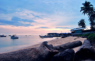
Pulau Hantu is located to the south of the main island of Singapore, off the Straits of Singapore. Pulau Hantu is actually made up of two islets: Pulau Hantu Besar and Pulau Hantu Kechil, with a total area of 12.6 hectares. At low tide, it is possible to wade across the shallow lagoon between the two islands, but not at high tide.

The Babar Islands(Indonesian: Kepulauan Babar) are located in Maluku Province, Indonesia between latitudes 7 degrees 31 minutes South to 8 degrees 13 minutes South and from longitudes 129 degrees 30 minutes East to 130 degrees 05 minutes East. The group now constitutes five districts (kecamatan) within the Maluku Barat Daya Regency of Maluku province.

Run is one of the smallest islands of the Banda Islands, which are a part of the Moluccas, Indonesia. It is located within Banda District (kecamatan) in Central Maluku Regency.

Liran is a small island off the southwest coast of Wetar Island, Indonesia. Administratively it is part of West Wetar District within the Southwest Maluku Regency. The East Timorese island Atauro is 12 km to the southwest. Liran is the westernmost of the Barat Daya Islands in the province of Maluku. It covers an area of 39.14 km2 and had 841 inhabitants in 2019.
The Derawan Islands are in the province of East Kalimantan in Indonesia. They consist of 31 islands, most well known among these are the islands of Derawan, Kakaban, Maratua, and Sangalaki. There are also numerous submerged reefs and islets. They are located in the Sulawesi Sea, on the coastal shelf of East Kalimantan. The islands are part of the Berau Regency.

The Banyak Islands are a group of inhabited islands located between Simeulue and Nias off the western coast of Sumatra in Indonesia's Aceh Province. Surveys of the area approximate around 71 islands and additional mangrove stands in shallow off-shore areas, although locals count 99 islands. The largest island in the group is Tuangku, with the principal village of Haloban on its southwest coast. Two other major islands located either side of Tuangku are Bangkaru (uninhabited) to the southwest, and Ujung Batu or Banjak Island to the northeast. Tuangku is separated from Bangkaru by a fault line.

Weh Island is a small active volcanic island to the northwest of Sumatra in Indonesia, also known as Sabang after the city situated on the northeast end of the island, whose area of 122.13 square kilometres (47.15 sq mi) includes the whole island as well as several offshore islets. It had a population of 43,527 at the official mid-2023 estimate. It is 45 minutes by fast regular ship or 2 hours by ferry from the mainland port of Banda Aceh. It was originally connected to the Sumatran mainland and became separated by sea after the stratovolcano's last eruption in the Pleistocene era. The island is situated in the Andaman Sea.
Badas Islands is a group of islands in the Tudjuh Archipelago in the South China Sea between the Malaysian mainland to the west and the island of Borneo to the east. Administratively it is part of Bintan Regency within the Riau Islands province of Indonesia under island district/kecamatan of Tambelan.

North Halmahera Regency is a regency of North Maluku Province, Indonesia. It was declared a separate Regency on 25 February 2003, formed from part of the former North Maluku Regency. The capital town of the regency lies at the port of Tobelo. The Regency, which was considerably reduced by the separation of Morotai Island to form a separate regency on 26 November 2008, now covers an area of 3,404.27 square kilometres (1,314.40 sq mi) and had a population of 161,847 people at the 2010 Census, 179,783 at the 2015 Intermediate Census. and 197,640 at the 2020 Census. The official estimate as at mid 2023 was 203,213. The principal settlements are Tobelo, Kao and Galela. The area is noted for its white beaches and coral reefs.
Medang Island is an island group off the north coast of Sumbawa, west of Moyo Island, in the Flores Sea. It is actually composed of two islands, Medang Besar and Medang Kecil, administratively called Bajo Medang and Bugis Medang; together they cover an area of about 28 km2 and had a combined population of about 3,000 in 2022. There are coral reefs in this area, with sharks and giant sponges.

Pulau Reni is a small Indonesian island located in the Ayu Archipelago above the northern tip of the Waigeo Islands.
Babi Island is an island located off the coast of Flores, East Nusa Tenggara. The 1992 Flores earthquake and tsunami are estimated to have killed 263 to 700 residents of the island, with most of the destruction on the southern end of the island.
Rondo Island is Indonesia's northernmost territory, located in the Andaman Sea, with a 0.650 km2 area 35m above sea level. The island is one of the outlying islands of Indonesia in the Aceh province of the Sumatra region. It is administratively part of Ujung Bau village in the Sukakarya District of Sabang City, whose administration center is on Weh Island, south of Rondo. Rondo is 50 km offshore from Indonesia's Sumatra mainland. This otherwise uninhabited island, accessible only by boat, has an Indonesian military outpost with a heliport and blue-roofed barracks, an adjacent lighthouse complex with a red-roofed lighthouse keeper's house and a white skeletal lighthouse topped with a viewing gallery and lantern.
Dengke mas naniura is a traditional Batak dish originating from the North Sumatra province of Indonesia. The name of the dish means "pickled fish" in the Toba Batak language. The dish is made with raw carp which is soaked in Kaffir limes and seasoned with andaliman. According to local oral tradition, only Batak kings were allowed to eat the dish, but in modern times there is no such restriction.

Manipa Island is an island in West Seram Regency, Maluku Province, Indonesia. It is located 8 km off the western coast of Kelang at the western end of Seram Island and 25 km off the western coast of Buru. Including adjacent small islands, it covers an area of 159.71 km2. The inhabitants speak the Manipa language, as well as Indonesian and Ambonese Malay.

The Thousand Islands are a chain of islands to the north of Jakarta's coast. It forms the only regency of Special Capital Region of Jakarta, the metropolitan province of Indonesia. It consists of a string of 342 islands stretching 45 km (28 mi) north into the Java Sea at West Jakarta Bay and in fact are located to the north of Banten Province. Pramuka Island is the regency seat. The islands, along with North Jakarta City, are the only administrative divisions of Jakarta Special Capital Region with a coastline.
Pulau Kanobe is a small Indonesian island located in the Ayu Archipelago above the northern tip of the Waigeo Islands.


