
Natuna Regency is an islands regency located in the northernmost part of the Province of Riau Islands, Indonesia. It contains at least 154 islands, of which 127 of them are reported as uninhabited. This archipelago, with a land area of 1,978.49 km2 out of a total area of 264,198.37 km2 area, contains 17 administrative districts (kecamatan).

Anambas Islands Regency is a small archipelago of Indonesia, located 150 nautical miles northeast of Batam Island in the North Natuna Sea between the Malaysian mainland to the west and the island of Borneo to the east. Geographically part of the Tudjuh Archipelago, it is administratively a regency within the Riau Islands Province. It covers a land area of 590.14 square kilometres (227.85 sq mi) and had a population of 37,411 at the 2010 Census and 47,402 at the 2020 Census; the official estimate as at mid 2023 was 49,090. The administrative centre is at Tarempa on Siantan Island.

The Lingga Regency is a group of islands in Indonesia, located south of Singapore, along both sides of the equator, off the eastern coast of Riau Province on Sumatra island. They are south of the populated Riau Archipelago, known for the industrial island of Batam and the tourist-frequented island of Bintan, although the Lingga Islands themselves are rarely visited due to the infrequent local transportation. The equator goes through the northern tip of Lingga Island, the main island in the archipelago.
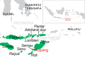
Pantar is the second largest island in the Indonesian Alor Archipelago, after Alor. To the east is the island of Alor and other small islands in the archipelago; to the west is the Alor Strait, which separates it from the Solor Archipelago. To the south is the Ombai Strait, and 72 kilometres (45 mi) away, the island of Timor. To the north is the Banda Sea. Pantar is about 50 kilometres (31 mi) north-to-south, and varies from 11 to 29 kilometres in east–west width. It has an area of 776.12 square kilometres (299.66 sq mi). The main towns on the island are Baranusa and Kabir. Administratively, the island is part of the Alor Regency.

The Batu Islands are an archipelago of Indonesia located in the Indian Ocean, off the west coast of Sumatra, between Nias and Siberut. The three primary islands, of approximately equal size, are Pini, Tanahmasa, and Tanahbala. There are seventy-five smaller islands, of which the largest are Sipika, Tello and Sigata, Simuk and Bojo ; less than half are inhabited. The total land area of the seven administrative districts is 1,201.1 km2. The islands are governed as a part of South Nias regency within North Sumatra province. In Indonesian and Malay, batu means rock or stone.

The Seram Sea or Ceram Sea is one of several small seas between the scattered islands of Indonesia. It is a section of the Pacific Ocean with an area of approximately one hundred twenty thousand square kilometres (46,000 sq mi) located between Buru and Seram, which are two of the islands once called the South Moluccas. These islands are the native habitat of plants long coveted for their use as spices, such as nutmeg, cloves, and black peppercorns, and the seas surrounding them were busy shipping routes. The Seram Sea is also the habitat of several species of tropical goby and many other fish. Like many other small Indonesian seas, the Seram Sea is rocky and very tectonically active.
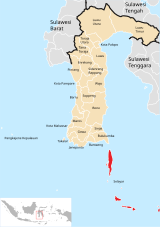
The Selayar Islands Regency is a regency of Indonesia in South Sulawesi province that covers the Selayar Islands, which lie southeast of the southern peninsula of Sulawesi. The archipelago consists of the group's main island, which is surrounded by 41 smaller islands around its coast; further to the southeast lies a widespread group of islands, including the smaller but still substantial islands of Pasimassunggu, Pasimarannu and Pasilambena in the far south, and the huge atoll of Takabonerate. The regency covers an area of 1,357.03 km2, and had a population of 103,596 at the 2000 Census, 122,055 at the Census of 2010 and 137,071 at that of 2020. The official estimate for mid 2023 was 142,100. The administrative centre is the town of Benteng on Selayar Island. The Selayar Straits separate the regency from Sulawesi island.

Alor Regency is a regency in East Nusa Tenggara (NTT) province of Indonesia. Established in 1958, Alor Regency administers the Alor Archipelago with its seat (capital) in Kalabahi on Alor Island.
Tambelan archipelago is a group of 68 islands off the west coast of West Kalimantan, (Borneo), Indonesia, just north of the equator. The archipelago is located on the north opening of Karimata Strait which separates Borneo and Belitung island. Geographically it is part of the Tudjuh Archipelago, and administratively forms a district (kecamatan) of Bintan Regency within the Riau Islands Province. It covers a land area of 90.4 km2 and had a population of 4,960 in mid 2022. Major islands include Big Tambelan, Mendarik, Uwi, Benua, and Pejantan. The islands are divided into eight administrative villages (kelurahan) - Batu Lepuk, Kampung Hilir, Kampung Melayu, Kukup, Pengikik, Pulau Mentebung, Pulau Pinang and Teluk Sekuni. As a historical side note; It was the first Dutch territory captured by the Japanese in World War 2.

The Asia Islands are a group of three small islands in the open sea north of the Raja Ampat Archipelago of eastern Indonesia. They are located 117 kilometres (73 mi) north of the island of Waigeo, around 50 kilometres (31 mi) north of the last of the Ayu Islands, and 210 kilometres (130 mi) south of the island of Tobi in Palau. The individual islands are known as Fani, Igi and Miarin. On the largest island of Fani, there is a pier and a small settlement, intermittently inhabited by visitors from Reni and Rutum. Administratively the Asia Islands are part of the Raja Ampat Regency of the province of Southwest Papua.

The Ayu Islands, are a small archipelago south of the Asia Islands and north of Raja Ampat Islands in Indonesia. This group is formed by two coral atolls. The highest point is 106 m.
Badas Islands is a group of islands in the Tudjuh Archipelago in the South China Sea between the Malaysian mainland to the west and the island of Borneo to the east. Administratively it is part of Bintan Regency within the Riau Islands province of Indonesia under island district/kecamatan of Tambelan.

The Goromarchipelago is a group of islands situated between the Watubela archipelago and Ceram in the Maluku Islands.

Biak Numfor Regency is one of the regencies (kabupaten) in Papua Province of Western New Guinea in northeastern Indonesia.
Pulau Ayu, often called Pulau Aju, Ayau or simply Ajoe, is a small Indonesian island located in the Ayu Islands above the northern tip of the Waigeo Islands.
Pulau Reni is a small Indonesian island located in the Ayu Archipelago above the northern tip of the Waigeo Islands.

Tual is a city in Maluku Province of Indonesia, geographically located within the Kei Islands. On 17 July 2007, it was separated from the rest of the Kei Islands and was created an independent city.

Doom Island is a small island in Southwest Papua, Indonesia. It is administratively part of the city of Sorong, specifically the Sorong Islands District.


