Punta Bes

Last updated
Punta Bes
Punta Bes da Punta Leynir.png
Punta Bes from Punta Leynir
Highest point
Elevation 3,177 m (10,423 ft) [1]
Prominence 65 m (213 ft) [2]
Parent peak Punta Leynir
Coordinates 45°30′43″N7°08′16″E / 45.51190°N 7.13788°E / 45.51190; 7.13788 Coordinates: 45°30′43″N7°08′16″E / 45.51190°N 7.13788°E / 45.51190; 7.13788
Geography
Alps location map.png
Red triangle with thick white border.svg
Punta Bes
Location in the Alps
Location Piedmont/Aosta Valley, Italy
Parent range Graian Alps
Climbing
Easiest route scrambling

The Punta Bes is a 3,177 [1] metres high mountain belonging to the Italian side of Graian Alps.

Contents

Geography

The mountain is located on the border between Piedmont and Aosta Valley, on the watershed dividing Valle dell'Orco from Valsavarenche, the latter tributary of the Dora Baltea. A 3.112 m high saddle [1] divides Punta bes from Punta Leynir, while the Orco/Valsavarenche ridge continues towards the Colle del Nivolet. [3] The Punta Bes, due to its location, offers a good view on the nearby massif of Gran Paradiso.

SOIUSA classification

According to SOIUSA (International Standardized Mountain Subdivision of the Alps) the mountain can be classified in the following way: [4]

Access to the summit

The mountain can be accessed from Nivolet Pass (2.641 m); this route requires a good hiking experience. [5] Along with Punta Bes many hikers also climb the nearby Punta Leynir. [6]

Mountain huts

Nature protection

Punta Bes belongs to the Parco Nazionale del Gran Paradiso. [3]

Maps

Related Research Articles

Gran Paradiso

The Gran Paradiso or Grand Paradis is a mountain in the Graian Alps in Italy, located between the Aosta Valley and Piedmont regions.

Rocciamelone

Rocciamelone is a 3,538 m high mountain in Piedmont, Italy, near the border between Italy and France.

Grivola

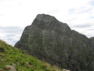
The Grivola is a mountain in the Graian Alps in Italy. It lies between the Valsavarenche and the Cogne Valley.

Monte Mars Mountain in Italy

Monte Mars(in Italian) or Mont Mars(in French), at 2,600 m, is the highest peak of the Biellese Alps, north-western Italy.

Herbétet

Herbétet is a mountain in the Gran Paradiso massif, a sub-group of the Graian Alps, with an elevation of 3,778 m. It is located between the Cogne Valley and the Valsavarenche Valley.

Orco Valley

The Orco Valley is a valley in the Piedmont region of northern Italy located in the Graian Alps, in the territory of the Metropolitan City of Turin. The valley takes its name from the Orco river, which flows through the valley.

Monte Tagliaferro

Monte Tagliaferro is a mountain of the Pennine Alps. It is one of the most popular hiking destination of Valsesia.

Monte Orsiera

Monte Orsiera is a mountain in the Cottian Alps belonging to the Province of Turin (Italy).

Monte Cresto

Monte Cresto (2,548 m) is the third highest peak of the Province of Biella after Monte Mars (2,600 m) and Monte Bo (2,556 m).

Croce Rossa

The Croce Rossa or Croix Rousse is a mountain of the Graian Alps, on the border between Piedmont, Italy and Savoie, France.

Punta Sulè Mountain in Italy

Punta Sulè is a 3,384 m a.s.l.mountain of the Graian Alps, located in Italy.

Bric Ghinivert Mountain in Italy

Bric Ghinivert or Eiminàl is a mountain of the Cottian Alps located in Italy.

Punta Tempesta Mountain in Italy

Punta Tempesta is a 2,679 m a.s.l. mountain of the Cottian Alps, located in Italy.

Monte Monega Mountain in Italy

Monte Monega is a 1,882-metre (6,175 ft) mountain of the Ligurian Alps, in Italy.

Corno Bussola Mountain in Italy

Corno Bussola is a 3,023 metres high peak on the Italian side of the Pennine Alps.

Mont-Fallère Mountain in Italy

The Mont-Fallère or Mont Fallère is a 3,061.5 metres high mountain belonging to the Italian side of Pennine Alps.

Mont Tout Blanc Mountain in Italy

The Mont Tout Blanc is a 3,438.2 metres high mountain belonging to the Italian side of Graian Alps.

Punta Leynir Mountain in Italy

The Punta Leynir is a 3,238 metres high mountain belonging to the Italian side of Graian Alps.

Punta Cornour Mountain in Italy

The Punta Cornour is a 2,868 metres high mountain on the Italian side of the Cottian Alps.

Cima Ciantiplagna Mountain in Italy

The Cima Ciantiplagna is a mountain in the Cottian Alps belonging to the Province of Turin (Italy).

References

  1. 1 2 3 "Navigatore Cartografico SCT (3.14.0)". geonavsct.partout.it. Regione Autonoma Valle d'Aosta / Région autonome Vallée d'Aoste. Retrieved 2018-12-19.
  2. Key col:unnamed 3.112 m saddle between Punta Bes and Punta Leynir
  3. 1 2 Carta dei sentieri e dei rifugi scala 1:50.000 n. 3 Il Parco Nazionale del Gran Paradiso, Istituto Geografico Centrale - Torino
  4. Marazzi, Sergio (2005). Atlante Orografico delle Alpi. SOIUSA (in Italian). Priuli & Verlucca. ISBN   978-88-8068-273-8.
  5. laika58 (2016-08-13). "Bes (Punte Nord e Sud) dai Piani del Nivolet per il Col Bes" (in Italian). Retrieved 2018-12-25.
  6. Berutto, Giulio (1979). "Punta del Leynir o Punta Vaudaletta". Il parco nazionale del Gran Paradiso (in Italian). 1. Istituto Geografico Centrale. pp. 168–169.