
The geography of Italy includes the description of all the physical geographical elements of Italy. Italy, whose territory largely coincides with the homonymous geographical region, is located in southern Europe and comprises the long, boot-shaped Italian Peninsula crossed by the Apennines, the southern side of Alps, the large plain of the Po Valley and some islands including Sicily and Sardinia. Italy is part of the Northern Hemisphere. Two of the Pelagie Islands are located on the African continent.

Punta del Este is a city and seaside resort on the Atlantic Coast in the Maldonado Department of southeastern Uruguay. Starting as a small town, Punta del Este later became internationally known as a resort for the Latin and North American jet set and tourists. Although the city has a year-round population of about 9,280, the summer season greatly adds to this number.

Monte Rosa is a mountain massif in the eastern part of the Pennine Alps. It is between Italy's and Switzerland's (Valais). Monte Rosa is the second highest mountain in the Alps and western Europe, after Mont Blanc.

Laglio is an Italian comune of 930 inhabitants in the Province of Como in Lombardy. It is on the western shore of the south-western branch of Lake Como, 14 kilometres (9 mi) from the town of Como.

Monte Argentario is a comune (municipality) and a peninsula belonging to the Province of Grosseto in the Italian region Tuscany, located about 150 kilometres (93 mi) south of Florence and about 35 kilometres (22 mi) south of Grosseto. The peninsula is connected with the mainland by three spits of land which form two lagoons, the Laguna di Ponente on the west side and the Laguna di Levante on the east side of the middle dam. The two main villages on Monte Argentario are Porto Santo Stefano, chief town, facing north, and Porto Ercole facing south.
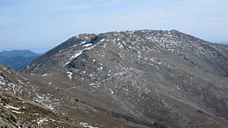
Punta La Marmora is a mountain in the Gennargentu range, Sardinia (Italy).

Valsesia is a group of valleys in the north-east of Piedmont in the Province of Vercelli, Italy; the principal valley is that of the river Sesia.
The Wasenhorn is a mountain of the Lepontine Alps, located on the border between Switzerland and Italy. It lies halfway between Brig and Varzo, just north of Monte Leone, in the Simplon Pass area. Politically the Wasenhorn is split between the municipalities of Ried-Brig and Varzo.

The Bortelhorn is a mountain of the Lepontine Alps on the Swiss-Italian border. On its west side it overlooks the Gantertal.

The Surettahorn is a mountain in the Oberhalbstein Range of the Alps located on the border between Italy and Switzerland. It overlooks the Splügen Pass on its west side.

La Spedla is a minor summit south of Piz Bernina on the border between Italy and Switzerland. With a height of 4,020 metres above sea level, it is the highest summit on the Italian side of the Bernina Range and the highest summit in Lombardy. Because of its small prominence it was included only in the enlarged list of alpine four-thousanders.

A street circuit is a motorsport racing circuit composed of temporarily closed-off public roads of a city, town or village, used in motor races. Airport runways and taxiways are also sometimes part of street circuits. Facilities such as the paddock, pit boxes, fences and grandstands are usually installed temporarily and removed soon after the race is over but in modern times the pits, garages, race control and main grandstands are sometimes permanently constructed in the area. Since the track surface is originally planned for normal speeds, race drivers often find street circuits bumpy and lacking grip. Run-off areas may be non-existent, which makes driving mistakes more expensive than in purpose-built circuits with wider run-off areas. Racing on a street circuit is also called "legal street racing".
Bari Light, also known as Punta San Cataldo di Bari Lighthouse is an active lighthouse placed at the base of Molo San Cataldo, on the west side of the harbour of Bari on the Adriatic Sea, in the southern region of Apulia, Italy.

The Orco Valley is a valley in the Piedmont region of northern Italy located in the Graian Alps, in the territory of the Metropolitan City of Turin. The valley takes its name from the Orco river, which flows through the valley.
The Furggubäumhorn is a mountain of the Lepontine Alps, which is located on the border between Switzerland and Italy. It is located on the main chain of the Alps, approximately halfway between the Wasenhorn and the Bortelhorn.

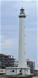
Punta Tagliamento Lighthouse is a lighthhose in Bibione a frazione of San Michele al Tagliamento, Veneto on the coast of the Adriatic Sea. It is placed on the beach protected by several seawalls placed as erosion control.
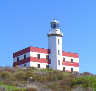
Punta di Capel Rosso lighthouse or Punta Rossa is an active lighthouse on Isola del Giglio on the Tyrrhenian Sea.
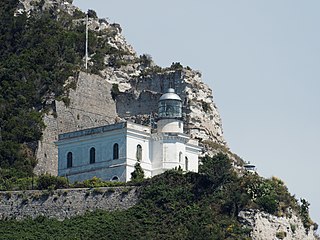
Punta Imperatore Lighthouse is an active lighthouse located atop an impressive overhanging promontory in the westernmost point of Ischia, Campania on the Tyrrhenian Sea. The lighthouse serves Naples as sighting approach.
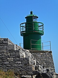
Punta Santa Teresa Lighthouse is an active lighthouse located at the east side, opposite to the outer breakwater of the gulf of La Spezia, in the municipality of Lerici, Liguria on the Ligurian Sea.
Punta Pesce Spada, also called Punta Cavallo Bianco, constitutes the southernmost point of Italy and is located on the southern side of Lampedusa, a Sicilian island of the Pelagie archipelago in the province of Agrigento, does not belong to the Italian geographical region but to the African Plate.
