Kottayam is one of 14 districts in the Indian state of Kerala. Kottayam district comprises six municipal towns: Kottayam, Changanassery, Pala, Erattupetta, Ettumanoor, and Vaikom. It is the only district in Kerala that neither borders the Arabian Sea nor any other states.

Meenachil is the north-eastern region of Kottayam district in Kerala, south India. The name originates from Meenakshi, the Hindu Goddess. Pala is the main city in Meenachil. The arterial river of the district is also named Meenachil.

Changanassery, also spelled Changanacherry, [t͡ʃɐŋːɐnɐːʃːeːɾi] is a municipality in the Kottayam district of Kerala, India. It is also the headquarters of the Changanassery Taluk. The town is spread over an area of 14.3 km2 (5.5 sq mi) and has a population of 47,685. Changanassery is located 17 km (11 mi) south of the district headquarters Kottayam and 117 km (73 mi) north of the state capital Thiruvananthapuram.

Monippally is a small village in Kottayam district, Kerala, South India. Formerly known as 'Mohanappally' or 'Munippally'. In her yesteryears, Monippally was a famous ginger cultivation area in Central Travancore. Dry Ginger, Turmeric and Kacholam were the main attractions of trade.

Muvattupuzha is a town, municipality in the midlands directly to the east of Kochi in Ernakulam district, Kerala, India. It is located about 36 km (22 mi) from downtown Kochi, and is a growing urban centre in central Kerala. The town is also the starting point of the Muvattupuzhayar, which is a confluence formed by three rivers: the Thodupuzhayar, Kaliyar, and Kothayar.
Mundakayam, is a town in Kanjirappally Taluk in the Kottayam District of Kerala. It is the doorway to the high ranges of southern Kerala, and is at the border of Kottayam and Idukki districts. The next nearest town, Kanjirappally, is 14 km (8.7 mi) & Erumely is 12 km from Mundakayam. Mundakayam has rubber plantations, and greenery. The Manimala River runs through Mundakayam. It is located 48 km east of the district headquarters at Kottayam and 148 km from the state capital, Thiruvananthapuram. The name Mundakayam is said to be derived from the Mundi cranes that used to be seen along the Manimala River banks.

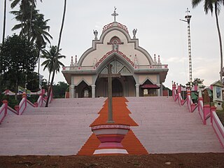
Manarcad is a small town in Kottayam district of Kerala state, South India. It is known for the Manarcad Perunnal, the annual feast at the St. Mary's Church, which is usually held from September 1-8. It is located about 9 km from the town of Kottayam and is on the way to tourist town of Thekkady.

Pampady is a fast growing town in Kottayam district of Kerala, Southern India. It lies midway between the backwaters of Western Kerala and the mountains of the Western Ghats.

Ettumanoor, sometimes spelled Ettumanur, is a major town and municipality in the Kottayam district of Kerala, India, located 11 kilometers north-east of Kottayam city, 50 kilometers south of Cochin, and 70 kilometers south of Cochin International Airport. The SH-1 popularly known as the Main Central (MC) Road, passes through Ettumanoor, and is a major connecting link between Pala and beyond, to the Western Ghats and to the commercial capital of Kerala - Kochi. Ettumanoor is en route to the tourist destinations at Wagamon and Poonjar.

Uzhavoor is an expanding town in Kottayam district, Kerala in India. It is just 32 km away from the administrative capital Kottayam District. Most of its residents are either wealthy farmers or businessmen. Many of the houses belong to NRIs. The tenth President of India, K. R. Narayanan, was born and brought up in this village. The newly expanded road which connects the city of Pala and other destinations such as Sabarimala to the city of Muvattupuzha passes through Uzhavoor. The town is 177 km from the state capital Thiruvananthapuram.

Kuthuparamba or Koothuparamba is a town and a municipality in the Kannur district, state of Kerala, India. It is about 24 km south-east of Kannur and 14 km east of Thalassery.

Kottayam is a city in the Indian state of Kerala, flanked by the Western Ghats on the east and the Vembanad Lake and paddy fields of Kuttanad on the west. It is the district headquarters of Kottayam district, located in south-west Kerala. Kottayam is located in the basin of the Meenachil River at an average elevation of 3 metres (9.8 ft) above sea level, and has a moderate climate. It is located approximately 155 kilometres (96 mi) north of the state capital Thiruvananthapuram.
The Main Central Road better known as MC Road is the arterial State Highway starting from Kesavadasapuram in Trivandrum city and ends at Angamaly, a suburb of Kochi city in Ernakulam District, in the state of Kerala, India. It is designated as State Highway 1 by the Kerala Public Works Department. The highway was built by Raja Kesavadas, Dewan of Travancore, in 1790's. Plan for a new highway called Thiruvananthapuram–Angamaly Greenfield Highway, which runs parallel to the MC Road is proposed and is under early stage of development.

Kangazha is a panchayath and village in the Changanacherry Taluk of the Kottayam District of Kerala State in India. It is located 21 kilometers east of Kottayam and 10 kilometers north of Karukachal. It lies midway between the backwaters of Western Kerala and the misty mountains of the Western Ghats.

Erumely, also spelt Erumeli, is a town and panchayat located in the south-eastern part of Kottayam district in Kerala state, India. Erumely is situated 49 km (30 mi) east of Kottayam town and 133 km (83 mi) north of capital city Thiruvananthapuram. It is situated on the way to Sabarimala and during pilgrimage season, Erumely and its surroundings will be crowded by devotees from different parts of Kerala as well as other states. Erumely is also renowned for its religious harmony and prosperity between Hindus and Muslims which existed from the early periods. It is a place which have strong roots in legends and myths associated with Hindu deity Ayyappa. A new airport has been proposed in Erumeli. The village is nourished by Manimala River.
Vazhoor is a town in Kottayam district in the state of Kerala, India.It is a village, panchayat and block with headquarters at Kodungoor on NH183. Basically an agrarian community inhabits this part, whose income depends on rubber cultivation
Kudakkachira is a small village 9 km away from Palai on Pala-uzhavoor road of Ernakulam - Sabarimala state highway in Kottayam district, Kerala, India. It is part of Meenachil Taluk. The majority of people are Syrian Malabar Nasrani. This region is part of the midlands of south-eastern kerala. Main income is from agriculture, mostly rubber plantations.

Anakkara is a geographic area of around 50 square kilometres that spans across Vandanmedu, Chakkupallam Panchayats in the Udumbanchola Taluk of Idukki District. Anakkara is the administrative capital of Chakkupallam Grama Panchayat and Anakkara Revenue Village. Situated at about 18 kilometers (11 mi) from Thekkady wildlife sanctuary on the Kumily-Munnar state highway, Anakkara is a fast-growing tourist destination for its unique spice gardens and many picnic spots in and around. It is one of the 36 distinct places identified by Government of India and United Nations Development Programme for exploring and promoting the unique tourism potential of these places.

Muttom is a rural area in Idukki district in the Indian state of Kerala. This place is 66 km away from Cochin. Geographically this place is part of Midland or Idanad region of Kerala.
Areekara is a small agricultural village North of Kottayam District, Kerala, India. It is connected by Road to Veliyannoor, Puthuvely, Uzhavoor and Ramapuram. There is an Upper Primary School, St. Rockey's, Catholic Church and Hindu Temple. The village is primarily agricultural with no business or industrial locations. Many people from Areekara live in Gulf and Western countries and that is one of the major source of income of the village. All Kerala Tug of War competition conducted by Areekara Club is one of the famous events which takes place every year in Areekara.


