
Krishna district is one of the twenty-six districts in the Indian state of Andhra Pradesh, with Machilipatnam as its administrative headquarters. It is the coastal district of Andhra Pradesh. Machilipatnam is the most populated city in the district. It is surrounded on the east by Bay of Bengal, west by Guntur and north by Eluru and NTR districts and south by Bay of Bengal. In 2022 Krishna district was divided into Krishna and NTR districts.

West Godavari district is one of the Twenty six districts in the andhra region of the Indian state of Andhra Pradesh. The administrative headquarters of the district is situated at Bhimavaram. As of 2011 census of India, the district has an area of 7,742 km2 (2,989 sq mi) and a population of 17,79,935 It is bounded by Eluru District on the North, Krishna district and Bay of Bengal on the South, East Godavari district on the East, Eluru District, Kolleru Lake and Upputeru Drain on the West.
Sullurupeta is a town in Tirupati district of Andhra Pradesh, India. It is a municipality and the headquarters of Sullurpeta mandal and Sullurpeta revenue division. It serves as a gateway to Satish Dhawan Space Centre(SDSC) at Sriharikota.

Guntur district is one of the nine districts in the Coastal Andhra region of the Indian state of Andhra Pradesh. The administrative seat of the district is located at Guntur, the largest city of the district in terms of area and with a population of 670,073. It has a coastline of approximately 100 km (62 mi) on the right bank of Krishna River, that separates it from Krishna district and extends till it empties into the Bay of Bengal. It is bounded on the south by Prakasam district and on the west by the state of Telangana. It has an area of 11,391 km2 (4,398 sq mi) and is the 2nd most populous district in the state, with a population of 4,889,230 as per 2011 census of India.

Nuzvid is a city in Eluru district of the Indian state of Andhra Pradesh. It serves as the administrative headquarters for Nuzvid mandal and Nuzvid revenue division.
Vuyyuru is a town in Krishna district of the Indian state of Andhra Pradesh. It is a Nagar panchayat and the headquarters of Vuyyuru Mandal. It is emerging as neighbourhood of Vijayawada, India situated 30 km away.

Nemali is a village in Krishna district of the Indian state of Andhra Pradesh. It is located in Gampalagudem mandal of Nuzvid revenue division. The word Nemali means "peacock" in Telugu.
Gampalagudem is a village in Krishna district of the Indian state of Andhra Pradesh. It is the headquarters of Gampalagudem mandal administered under Nuzvid revenue division. The village is located on the banks of Kattaleru River, at a distance of 145 km (90 mi) from the district headquarters, Machilipatnam and 74 kilometres (46 mi) from Vijayawada.
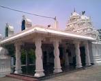
Agiripalli is a town and Mandal Headquarters, in Krishna district of the Indian state of Andhra Pradesh. It is located in Agiripalli mandal Agiripalli is famous for Laxmi Narsimha Swamy Temple.
Atlapragada Konduru is a village in NTR district of the Indian state of Andhra Pradesh. It is the mandal headquarters of Atlapragada Konduru mandal under Tiruvuru revenue division.

Koduru is a village in Krishna district of the Indian state of Andhra Pradesh. It is the Mandal headquarters of Koduru Mandal in Machilipatnam Revenue Division.

Mopidevi is a village in Krishna district of the Indian state of Andhra Pradesh. It is the mandal headquarters of Mopidevi mandal in Machilipatnam revenue division. It is one of the villages in the mandal to be a part of Andhra Pradesh Capital Region. The village is known for its famous Lord Subrahmanyeswar Swamy Temple. The village is situated 80Km from Vijayawada and 30Km from Machilipatnam.
Movva is the name of a well-known village in the Krishna district of the Indian state known as Andhra Pradesh. It is located in 'Movva mandal of Machilipatnam revenue division'. It is one of the villages in the mandal to be a part of Andhra Pradesh Capital Region.

Mylavaram is a town in NTR district of the Indian state of Andhra Pradesh. It is located in Mylavaram mandal of Vijayawada revenue division. Mylavaram village has higher literacy rate compared to Andhra Pradesh.In 2011, literacy rate of Mylavaram village was 76.49% compared to 67.02% of Andhra Pradesh.
Pamarru is a village in Krishna district of the Indian state of Andhra Pradesh. It is located in Pamarru Mandal in Gudivada revenue division..

Penuganchiprolu is a village in NTR district of the Indian state of Andhra Pradesh. It is the mandal headquarters of Penuganchiprolu mandal in Nandigama revenue division.
Vissannapeta is a village in NTR district of the Indian state of Andhra Pradesh.
Kollur is a village in Guntur district in the Indian state of Andhra Pradesh. It is the headquarters of Kollur mandal in Tenali revenue division.

Jaggayyapeta, also spelled “Jaggiahpet”, is a census town in NTR district of the Indian state of Andhra Pradesh, located just southwest of the border with Telangana. It is also the mandal headquarters of Jaggayyapeta mandal of Nandigama revenue division. The town is located on the banks of the Paleru River which is a tributary of the Krishna River.
Chandrala is a village in Krishna district of the Indian state of Andhra Pradesh. It is located in Mylavaram mandal of Vijayawada revenue division. It is one of the villages in the mandal to be a part of Andhra Pradesh Capital Region.
