External links
52°43′01″N2°00′58″W / 52.717°N 2.016°W
| | This Staffordshire location article is a stub. You can help Wikipedia by expanding it. |
Pye Green is an English village on Cannock Chase in the south of Staffordshire standing nearly 800 feet above sea-level, literally overlooking Hednesford, Cannock, Walsall and much of the Black Country. Birmingham city centre can be clearly seen when the weather is good.
Pye Green is served by roads running from Hednesford to Stafford and from Chadsmoor to Slitting Mill and Etchinghill. The closest trunk roads are the A34 from Cannock to Stafford and the A460 from Cannock to Rugeley. Bus services are provided by Chaserider PyeGreen--Hednesford--Cannock--Pye Green and vice-versa, circular services 25/26 with a 15-or 30-minute frequency, Mon-Sat. The closest railway station is at Hednesford, which is on the Chase Line running from Rugeley Trent Valley to Birmingham New Street.
In the past 100 years, the population of village has grown from possibly less than 150 people to perhaps as many as 6,000. This is mainly though council and coal board housing, and latterly through private housing, mainly down the Pye Green Valley. Today, therefore, the housing is mainly owner-occupied, with some private rentals and some council housing, being the remnants of the council housing which was not privately purchased by former tenants. The area also boasts nursery and primary schools, a community centre, several shops (butcher's, takeaways, general dealers and convenience stores), a funeral director's, a pub and social club, a pavilion and sports ground, and an equestrian centre. The nearest secondary schools are Staffordshire University Academy and Kingsmead School, Hednesford.
The pub is named after a former local farmer, his Pye Green Farm predating the first housing estate comprising Clarkes Avenue and Cotton Grove, erected before WWII. Just after WWII, prefabs were erected west of this estate. They were replaced with more permanent dwellings in the 1970s and 1980s. In the meantime, council housing was developed east of this estate in conjunction with the coal board, bringing in an influx of mining families from Ayrshire, Northumberland and Durham, and South Wales in the 1960s to work in various pits in the Cannock Chase Coalfield. The land in the Pye Green Valley was developed in the 1980s onwards. This development has removed any green space gaps between Pye Green and Hednesford or Pye Green and Chadsmoor, and so it may not always be clear who lives in Pye Green and who doesn't.
Land to the west and north of the built area comprises what remains of The Chase, or Cannock Forest. Close by are the Commonwealth War Graves Cemetery and German Military Cemetery, and the ruined remains of Brindley Village and of RAF Hednesford.
The road out of Pye Green to the north-west towards Stafford climbs to the highest point for miles around. Because of this height, it hosts the local BT communications tower landmark (which can be seen from the nearby M6 motorway and the West Coast Main Line). The tower relays line-of-sight microwave communication links between equivalent towers at Sutton Common in Cheshire and in the centre of Birmingham, eventually down to London BT Tower. Near to the BT Tower is an older structure, the Pye Green Pumping Station and Water Tower, which has operated since 1934.
Other pieces of history, now barely visible, included gallops for thoroughbreds dating from when Hednesford was a significant training centre, before and during the advent of coal mining. They included a mission church (St. Marks) and a chapel (top of Bradbury Lane) which were part of the extension of christian buildings into the area in the 1890s. They included three working men's clubs which went with mining - only one still operates. The chapel (which was later part of one of the clubs and turf accountant's and then of a pub) overlooked a quarry which was subsequently used for landfill and is now a green space. The nearest working quarry now is to the west, above Pottal Pool, the latter having once been a lido. Oldest artefact of all is the Wishing Stone on or near the (possible) route of Blake Street (or Blake Road). Before the coming of canals and railways, this provided one of a few alternative routes for stage-coach travel between London and Chester or Birmingham and Manchester, via Hednesford through to Stafford. As for the mining, and the canals, railways and other infrastructure which went with it, the closest pits were sunk down the Pye Green Valley, fringing the Green Heath, Blake Street (Belt Road) and the railway to Cannock. This was the site of West Cannock pits nos. 1, 3 and 4.
Pye Green is the administrative headquarters of Hednesford Town Council, which meets in the Pye Green Community Centre (opened 1974. and renovated about 2012). Pye Green lies in the territories administered by Cannock Chase District Council and Staffordshire County Council. It is also in the Cannock Chase (UK Parliament constituency).
52°43′01″N2°00′58″W / 52.717°N 2.016°W
| | This Staffordshire location article is a stub. You can help Wikipedia by expanding it. |

Cannock Chase, often referred to locally as The Chase, is a mixed area of countryside in the county of Staffordshire, England. The area has been designated as the Cannock Chase National Landscape, an Area of Outstanding Natural Beauty, and much of it is managed by Forestry England for its important ecology and for recreational use. The Chase gives its name to the Cannock Chase local government district. It is a former Royal forest.

Cannock is a town in the Cannock Chase district in the county of Staffordshire, England. It had a population of 29,018. Cannock is not far from the towns of Walsall, Burntwood, Stafford and Telford. The cities of Lichfield and Wolverhampton are also nearby.

Rugeley is a market town and civil parish in the Cannock Chase District, in Staffordshire, England. It lies on the north-eastern edge of Cannock Chase next to the River Trent; it is situated 8 miles (13 km) north of Lichfield, 10 miles (16 km) south-east of Stafford, 5 miles (8.0 km) north-east of Hednesford and 11 miles (18 km) south-west of Uttoxeter. At the 2021 Census, the population was 26,156.

Burntwood is a former mining town and civil parish in the Lichfield District of Staffordshire, England. It is approximately 4 miles (6 km) west of Lichfield and north east of Brownhills, with a population of 26,049 and forming part of Lichfield district. The town forms one of the largest urbanised parishes in England. Samuel Johnson opened an academy in nearby Edial in 1736. The town is home to the smallest park in the UK, Prince's Park, which is located next to Christ Church on the junction of Farewell Lane and Church Road. The town expanded in the nineteenth century around the coal mining industry.
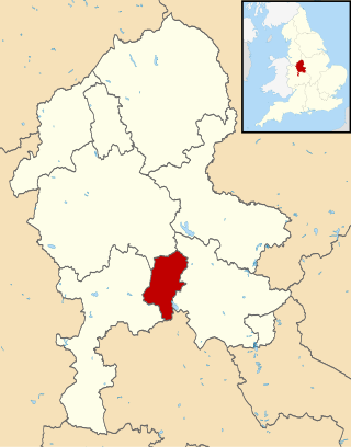
Cannock Chase is a local government district in Staffordshire, England. It is named after and covers a large part of Cannock Chase, a designated National Landscape. The council is based in the town of Cannock. The district also contains the towns of Hednesford and Rugeley, as well as a number of villages and surrounding rural areas.

Hednesford is a market town and civil parish in the Cannock Chase district of Staffordshire, England. The Cannock Chase area of natural beauty is to the north of the town. Hednesford is also 1 mile (1.6 km) to the north of Cannock and 5 miles (8.0 km) to the south of Rugeley. The population at the 2011 census was 17,343.

The Chase Line is a suburban railway line in the West Midlands region of England. It runs from its southern terminus, Birmingham New Street, to Walsall, and then Rugeley Trent Valley in Staffordshire, where it joins the Trent Valley line. The name of the line refers to Cannock Chase which it runs through at its northern end.

Walsall railway station is the principal railway station of Walsall, West Midlands, England and situated in the heart of the town. It is operated by West Midlands Trains, with services provided by West Midlands Railway. The main entrance is situated inside the Saddlers Shopping Centre.

Cannock railway station serves the town of Cannock in the Cannock Chase, Staffordshire, England. It is situated on the Chase Line. The station and all trains serving it are operated by West Midlands Trains. The station is located over half a mile from the centre of the town, close to the suburbs of Stoney Lea and Hawks Green.

Hednesford railway station serves the market town of Hednesford in Staffordshire, England. The station forms a part of the Chase Line and is operated by West Midlands Railway.
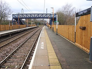
Rugeley Town railway station serves the market town of Rugeley, Staffordshire, England. The station is operated by West Midlands Railway, with services operated by West Midlands Railway and London Northwestern Railway. The station is situated around half a mile from Rugeley town centre. The station is located in Wharf Road.
The A460 is a main road in the Midlands of England. It runs from Wolverhampton in the West Midlands to Rugeley in Staffordshire. It is also a primary road linking Wolverhampton and Cannock with the M54, M6 and M6 Toll.
Valley Colliery, commonly known as Valley Pit, was a deep coal mine and training centre located in Hednesford, Staffordshire, UK.

Chadsmoor is a historic village in the Cannock Chase District in Staffordshire, England and is situated between the towns of Cannock and Hednesford.

The Cannock Chase Railways were mineral lines which served the collieries and many parts of Staffordshire. The branch lines and sidings branched off the local mainlines including the Grand Junction Railway, Chase Line, South Staffordshire Line and Rugby–Birmingham–Stafford line. The main junction on the railways was Norton Junction. This junction connected the lines from Walsall and Hednesford to Wolverhampton and Rugeley Trent Valley for the local collieries and the mines in the towns of Brownhills, Burntwood, Chasetown, Penkridge and Cannock.

Hazelslade is a former mining village in Staffordshire, England. It is now part of Cannock Chase District. The village is located between Hednesford and Rugeley. It has been built into the Rawnsley area of Hednesford and is now effectively a suburban village of Hednesford. The village has a post office, a freehouse and housing estates. There was also a former mineral railway which ran from Hednesford to Burntwood. It can be seen from Google Maps as rows of trees curving around the former mining village and parts of Cannock Chase District to the Chase Line. There is also a bus service which connects the village to Cannock and Burntwood. The nearest mainline railway station is Hednesford. The pub is also named the Hazelslade. The nearest churches are in Church Hill and Hednesford.
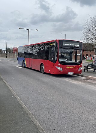
Chaserider is the brand name for bus services operated around Cannock and Staffordshire by D&G Bus, a local bus operator owned by Centrebus who are based in Adderley Green, Stoke-on-Trent, Staffordshire.

Hednesford Park is a park located in Hednesford, Staffordshire, England. The park covers an area of 24 acres, consisting of a recreational field area, running track, skatepark, play area, cafe, and tennis courts. The park is adjacent to Hednesford town centre and the Hednesford Hills nature reserve.