
The Struve Geodetic Arc is a chain of survey triangulations stretching from Hammerfest in Norway to the Black Sea, through ten countries and over 2,820 km, which yielded the first accurate measurement of a meridian.
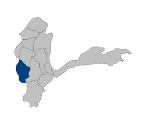
Tagab District is one of the 29 districts of Badakhshan Province in Afghanistan. It was created in 2005 from part of Fayzabad District and has a population of approximately 22,000 residents. The Karaste Canal is located in Tagab District.

Tandzut is a village in the Armavir Province of Armenia.

Birinci Yüzbaşılı is a village in the Agdam Rayon of Azerbaijan. The village forms part of the municipality of Xındırıstan.
Hinqar is a village in the Agsu Rayon of Azerbaijan. The village forms part of the municipality of Gürcüvan.
Dahar is a village in the Ismailli Rayon of Azerbaijan. The village forms part of the municipality of Cülyan. According to Azerbaijan's State Statistics Committee, only five people lived in the village as of 2014.
Zərgəran is a village in the Ismailli Rayon of Azerbaijan. The village forms part of the municipality of Bizlan.
Namazgah is a village in the Ismailli Rayon of Azerbaijan. The village forms part of the municipality of Ərəkit.
Nanıc is a village in the Ismailli Rayon of Azerbaijan. The village forms part of the municipality of Müdri.
Muğanlı is a village and municipality in the Kurdamir Rayon of Azerbaijan.
Şilyan is a village and municipality in the Kurdamir Rayon of Azerbaijan. The municipality consists of the villages of Şilyan and Qarasu.
Xaşı is a village in the Quba Rayon of Azerbaijan. The village forms part of the municipality of Qonaqkənd.
Mingə is a village in the Ismailli Rayon of Azerbaijan. The village forms part of the municipality of Keyvəndi. The area is renowned for excessive bush and dryness, due to being situated on one of the two highest peaks of Azerbaijan.

Kochanów is a village in the administrative district of Gmina Lubochnia, within Tomaszów Mazowiecki County, Łódź Voivodeship, in central Poland. It lies approximately 3 kilometres (2 mi) east of Lubochnia, 11 km (7 mi) north-east of Tomaszów Mazowiecki, and 48 km (30 mi) south-east of the regional capital Łódź.
Nowa Wieś Wschodnia is a village in the administrative district of Gmina Rzekuń, within Ostrołęka County, Masovian Voivodeship, in east-central Poland.
Wąsosze is a village in the administrative district of Gmina Ślesin, within Konin County, Greater Poland Voivodeship, in west-central Poland.
Mieścisko is a village in Wągrowiec County, Greater Poland Voivodeship, in west-central Poland. It is the seat of the gmina called Gmina Mieścisko. It lies approximately 11 kilometres (7 mi) south-east of Wągrowiec and 48 km (30 mi) north-east of the regional capital Poznań.

Młada Hora is a village in the administrative district of Gmina Ujsoły, within Żywiec County, Silesian Voivodeship, in southern Poland, close to the border with Slovakia.
Luojiang District is a district of Sichuan Province, China. It is under the administration of Deyang city.
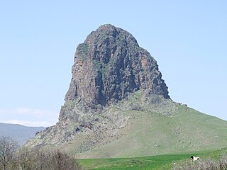
Mount Goyazan is a mountain in the northwestern Qazakh District of Azerbaijan. It is located in the vicinity of the villages Abbasbeyli and Alpout, and rises 857.9 metres above sea level. Ruins of a Goyazan fortress from the 14th century were found near the mountain.


