The Max Planck Institute for Astrophysics (MPA) is a research institute located in Garching, just north of Munich, Bavaria, Germany. It is one of many scientific research institutes belonging to the Max Planck Society.

Neu-Westend is a Berlin U-Bahn station located on the U 2. It opened in 1908 and was built by A. Grenander. In 1986 the station was renovated, the eastern entrance was kept in original.
Coquihalla River Provincial Park is a provincial park in British Columbia, Canada, located 25 km (16 mi) north of the town of Hope on BC Highway 5 adjacent to the Coquihalla River.

Pniewy is a town in Szamotuły County, Greater Poland Voivodeship, Poland, with 7,477 inhabitants as of 2004.
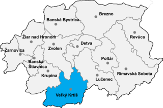
Vieska is a village and municipality in the Veľký Krtíš District of the Banská Bystrica Region of southern Slovakia.
Ľuboriečka is a village and municipality in the Veľký Krtíš District of the Banská Bystrica Region of southern Slovakia.

Porúbka is a village and municipality in the Sobrance District in the Košice Region of east Slovakia.
Bayanjargalan is a sum of Töv Province in Mongolia.
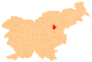
Dečkovo Naselje is a district and a neighborhood of the city of Celje in Slovenia.

Zar, is a village in the Kotayk Province of Armenia.

Çorman is a village in the Kalbajar Rayon of Azerbaijan.
Urmis is a village in the Nakhchivan Autonomous Republic of Azerbaijan.
Gabrielów is a village in the administrative district of Gmina Osjaków, within Wieluń County, Łódź Voivodeship, in central Poland. It lies approximately 4 kilometres (2 mi) south of Osjaków, 18 km (11 mi) east of Wieluń, and 74 km (46 mi) south-west of the regional capital Łódź.
Hoopersville is an unincorporated community in Dorchester County, Maryland, United States. The Hooper Island Light was listed on the National Register of Historic Places in 2002.
Smug is a settlement in the administrative district of Gmina Debrzno, within Człuchów County, Pomeranian Voivodeship, in northern Poland. It lies approximately 4 kilometres (2 mi) north-east of Debrzno, 13 km (8 mi) south-west of Człuchów, and 128 km (80 mi) south-west of the regional capital Gdańsk.
Obrzynowo is a village in the administrative district of Gmina Prabuty, within Kwidzyn County, Pomeranian Voivodeship, in northern Poland. It lies approximately 5 kilometres (3 mi) north-east of Prabuty, 23 km (14 mi) east of Kwidzyn, and 78 km (48 mi) south-east of the regional capital Gdańsk.

Jakomäki is a quarter, part of Suurmetsä neighbourhood in Helsinki, Finland. It has an area of 1,92 km2 and a population of 5,481 (2005).
31°58′05″N35°15′40″ESilwad Camp, is a Palestinian refugee camp north-east of Ramallah, was established in 1972. The transfer took place in the form of the restructuring of the Nuseirat, Shati and Bureij refugee camps in Gaza.
Kasti is a village in Saaremaa Parish, Saare County in western Estonia.

Trnjane is a village in the municipality of Požarevac, Serbia. According to the 2002 census, the village has a population of 915 people.


