
Union County is a county in the U.S. state of Indiana. As of the 2020 United States census, the population was 7,087. The county seat is Liberty.

Quakertown is a borough in Bucks County, Pennsylvania, United States. As of 2020, it had a population of 9,359. The borough is 15 miles (24 km) south of Allentown and Bethlehem and 40 miles (64 km) north of Philadelphia, making Quakertown a border town of both the Delaware Valley and Lehigh Valley metropolitan areas.
Telford is a borough in Bucks and Montgomery counties in the U.S. state of Pennsylvania. The population was 4,872 at the time of the 2010 census. Of this, 2,665 were in Montgomery County, and 2,207 were in Bucks County.

Pennsylvania Route 663 (PA 663) is a 22.13-mile-long (35.61 km) state highway in Montgomery and Bucks counties in southeast Pennsylvania. Its southern terminus is at PA 100 in the borough of Pottstown and its northern terminus is at PA 309 and PA 313 in the borough of Quakertown, where the road continues eastward as PA 313. Along the way, PA 663 also passes through the borough of Pennsburg. It is called John Fries Highway between Pennsburg and Quakertown. It has an interchange with Interstate 476 at exit 44 west of Quakertown. The route was assigned in 1930, and it has had several realignments since its commissioning, including two major ones.

Crown Hill National Cemetery is a U.S. National Cemetery located in Indianapolis, Marion County, Indiana. It was established in 1866 on Section 10 within Crown Hill Cemetery, a privately owned cemetery on the city's northwest side. Administered by the United States Department of Veterans Affairs, the National Cemetery encompasses 1.4 acres (0.57 ha) and serves as a burial site for Union soldiers who fought in the American Civil War.

Glen Hall is a small unincorporated community in Wayne Township, Tippecanoe County, in the U.S. state of Indiana.
Taylor is a small unincorporated community in Union Township, Tippecanoe County, in the U.S. state of Indiana.
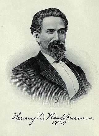
Henry Dana Washburn was a U.S. Representative from Indiana and a colonel and was breveted twice as brigadier general and major general in the Union Army during the American Civil War.
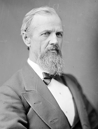
Milton Stapp Robinson was an Indiana lawyer, politician, judge, and soldier. He was a brigade commander in the Union Army during the American Civil War and a postbellum U.S. Representative, serving two terms from 1875 to 1879.

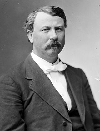
Strother Madison Stockslager was an American lawyer, Civil War veteran, and politician who served two terms as a U.S. Representative from Indiana from 1881 to 1885.
William Henry Calkins was an American lawyer and Civil War veteran who served four terms as a U.S. Representative from Indiana from 1881 to 1884.

Pennsylvania Route 212 is a 14.9-mile-long (24.0 km) state highway in Bucks County, Pennsylvania. The route runs from PA 313 in the borough of Quakertown northeast to PA 611 in Durham Township, just south of the borough of Riegelsville. The route, which is a two-lane undivided road its entire length, passes through rural areas of northern Bucks County, serving Richlandtown and Springtown. PA 212 has a concurrency with PA 412 through the Springtown area.

Harmony Township is one of six townships in Union County, Indiana, United States. As of the 2010 census, its population was 543 and it contained 233 housing units.

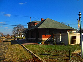
The Quakertown Passenger and Freight Station is a historic train station and freight depot located at Quakertown, Bucks County, Pennsylvania. The two buildings were designed by Wilson Bros. & Company in 1889 and built by Cramp and Co. for the Philadelphia and Reading Railroad in 1902. The passenger station is constructed of dark Rockhill granite and Indiana limestone and is in a Late Victorian style. It is 1+1⁄2 stories tall and measures 25 feet wide by 97 feet 6 inches, long. It has a hipped roof with an eight-foot overhang. The freight station is a 1+1⁄2-story, rectangular stone block building measuring 128 by 30 feet. Also on the property is a large crane that was used for freight movement. The Quakertown station had passenger rail service along the Bethlehem Line to Bethlehem and Philadelphia until July 27, 1981, when SEPTA ended service on all its intercity diesel-powered lines. SEPTA still owns the line and leases it to the East Penn Railroad. Other towns, stations, and landmarks on the Bethlehem Line are Perkasie, Pennsylvania, Perkasie Tunnel, and Perkasie station.

Milford Square is a census-designated place in Milford Township, Bucks County, Pennsylvania, United States. It is located along PA Route 663 near the borough of Trumbauersville. As of the 2010 census, the population was 897 residents. While the village has a PO Box post office, with the ZIP code of 18935, the surrounding area uses the Quakertown ZIP Code of 18951.

Bethlehem Union Station is a former train station located in the South Side neighborhood of Bethlehem, Pennsylvania. It was built in 1924 by the Lehigh Valley Railroad and the Reading Company, replacing an earlier station built in 1867. Passenger service to Philadelphia on the SEPTA Regional Rail Bethlehem Line lasted until 1981. The station was renovated in 2002 and used for medical clinics beginning in 2003. It is owned by St. Luke's Hospital.

The Cincinnati metropolitan area is a metropolitan area with its core in Ohio and Kentucky. Its largest city is Cincinnati and includes surrounding counties in the U.S. states of Ohio, Kentucky, and Indiana.
Octagon is an unincorporated community in Wabash Township, Tippecanoe County, in the U.S. state of Indiana.

Thomas P. Bossert is an American lawyer and former Homeland Security Advisor to U.S. President Donald Trump. He is an ABC News Homeland Security analyst.
Petrea is an unincorporated community in Lick Township, Jackson County, Ohio, United States. It is located on Ohio State Route 788 between Jackson and Wellston, at the intersection of Fairgreens Road, at 39°04′24″N82°36′03″W.


