Related Research Articles

Boise County is a rural mountain county in the U.S. state of Idaho. As of the 2020 United States Census, the population was 7,610. The county seat is historic Idaho City, which is connected through a series of paved and unpaved roads to Lowman, Centerville, Placerville, Pioneerville, Star Ranch, Crouch, Garden Valley, and Horseshoe Bend.

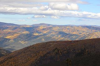
Placerville is a populated place in Boise County, Idaho, United States. The population was 53 at the 2010 census. It is part of the Boise City–Nampa, Idaho Metropolitan Statistical Area.
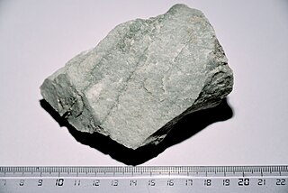
Quartzite is a hard, non-foliated metamorphic rock which was originally pure quartz sandstone. Sandstone is converted into quartzite through heating and pressure usually related to tectonic compression within orogenic belts. Pure quartzite is usually white to grey, though quartzites often occur in various shades of pink and red due to varying amounts of hematite. Other colors, such as yellow, green, blue and orange, are due to other minerals.
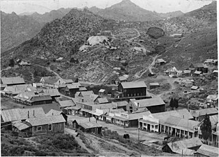
Silver City is a ghost town in northwestern Owyhee County, Idaho, United States, that is listed on the National Register of Historic Places (NRHP). At its height in the 1880s, it was a gold and silver mining town with a population of around 2,500 and approximately 75 businesses.

The Arabian-Nubian Shield (ANS) is an exposure of Precambrian crystalline rocks on the flanks of the Red Sea. The crystalline rocks are mostly Neoproterozoic in age. Geographically – and from north to south – the ANS includes parts of Israel, Jordan, Egypt, Saudi Arabia, Sudan, Eritrea, Ethiopia, Yemen, and Somalia. The ANS in the north is exposed as part of the Sahara Desert and Arabian Desert, and in the south in the Ethiopian Highlands, Asir province of Arabia and Yemen Highlands.

Hatcher Pass is a mountain pass through the southwest part of the Talkeetna Mountains, Alaska. It is named after Robert Hatcher, a prospector and miner. The nearest cities are Palmer and Wasilla approximately 12 miles (19 km) to the south, and Willow approximately 26 mi (42 km) to the west. The communities are at an elevation of approximately 250 ft (76 m) in the Mat-Su valley.
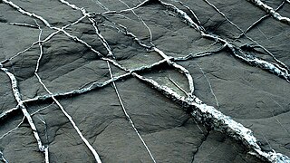
In geology, a vein is a distinct sheetlike body of crystallized minerals within a rock. Veins form when mineral constituents carried by an aqueous solution within the rock mass are deposited through precipitation. The hydraulic flow involved is usually due to hydrothermal circulation.
The history of Idaho is an examination of the human history and social activity within the state of Idaho, one of the United States of America located in the Pacific Northwest area near the west coast of the United States and Canada. Other associated areas include southern Alaska, all of British Columbia, Washington, Oregon, western Montana and northern California and Nevada.

James Henry Hawley was an American attorney and politician from Idaho. He was state's ninth governor from 1911 to 1913, and the mayor of Boise from 1903 to 1905. He also acted as prosecutor or defense attorney for a substantial number of criminal cases. Outside of criminal law, he specialized in irrigation and mining cases.

In the United States, gold mining has taken place continually since the discovery of gold at the Reed farm in North Carolina in 1799. The first documented occurrence of gold was in Virginia in 1782. Some minor gold production took place in North Carolina as early as 1793, but created no excitement. The discovery on the Reed farm in 1799 which was identified as gold in 1802 and subsequently mined marked the first commercial production.
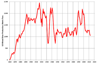
Silver mining in the United States began on a major scale with the discovery of the Comstock Lode in Nevada in 1858. The industry suffered greatly from the demonetization of silver in 1873 by the Coinage Act of 1873, known pejoratively as the "Crime of 73", but silver mining continues today.
Silver mining in Nevada, a state of the United States, began in 1858 with the discovery of the Comstock Lode, the first major silver-mining district in the United States. Nevada calls itself the "Silver State." Nevada is the nation's second-largest producer of silver, after Alaska. In 2014 Nevada produced 10.93 million troy ounces of silver, of which 6.74 million ounces were as a byproduct of the mining of gold. The largest byproducers were the Hycroft Mine, the Phoenix Mine, the Midas Mine and Round Mountain.
Gold mining in Alaska, a state of the United States, has been a major industry and impetus for exploration and settlement since a few years after the United States acquired the territory in 1867 from the Russian Empire. Russian explorers discovered placer gold in the Kenai River in 1848, but no gold was produced. Gold mining started in 1870 from placers southeast of Juneau, Alaska.
The Willow Creek mining district, also known as the Independence Mine/Hatcher Pass district, is a gold-mining area in the U.S. state of Alaska. Underground hard-rock mining of gold from quartz veins accounts for most of the mineral wealth extracted from the Hatcher Pass area. The first mining efforts were placer mining of stream gravels, and placer mining in the area has continued sporadically to this day. Robert Hatcher discovered gold and staked the first claim in the Willow Creek valley in September 1906. The first lode mill in the area started operating in 1908. Underground mining continued at a variety of locations around the pass until 1951. In the 1980s one of the area's hard-rock mines was briefly re-opened. At least one mining company is actively exploring for gold in the area now. Through 2006 the district produced 667-thousand ounces of hard rock gold and 60-thousand ounces of placer gold.
The Admiralty mining district is a mining area in the U.S. state of Alaska which consists of Admiralty Island. Silver and base metals are mined, with gold recovered as a by-product.

The Juneau gold belt is located in the southeastern portion of the U.S. state of Alaska. This belt is approximately 100 miles (160 km) in length, north/northwest-trending, and extends from Berners Bay southeastward to Windham Bay, 60 miles (97 km) southeast of Juneau, and includes Douglas Island. The belt contains over 200 gold-quartz-vein deposits with production nearing 7,000,000 ounces (200,000,000 g) of gold. More than three-quarters of Alaska's lode gold was mined from the Juneau gold belt.
The Wernecke Mountains are located in the East-central Yukon Territory of Canada. They have provided important wildlife habitat for animals such as grizzly bears and caribou as well as trapping and hunting land for the indigenous people of the Yukon for many centuries. They are the northernmost expression of the North American Cordillera, a chain of mountains stretching from Alaska to southern Mexico. This area has a northern climate characterized by short summers and long winters, with average temperatures from −26 °C (−15 °F) in the winter to 22 °C (72 °F) in the summer While essentially unpopulated, this area is well known for its rich mineral deposits, including gold, silver and copper.
The Las Pavas, also called La Pava, is a Colombian emerald mining area that is neighboring Colombia's largest emerald mine, Puerto Arturo. It is located 200 kilometres (120 mi) northwest of the capital Bogotá in the western emerald belt of Muzo, and about 235 kilometres (146 mi) west of Chivor, which is in the eastern emerald belt. The mining area spans the municipalities Quípama and Muzo.

Jefferson J. Standifer was an American gold miner, lawman, prospector, explorer, and member of the Knights of the Golden Circle. He was the first sheriff of Idaho County, and there is a street named after him in Placerville, Idaho where he resided for a short time.
An orogenic gold deposit is a type of hydrothermal mineral deposit. More than 75% of the gold recovered by humans through history belongs to the class of orogenic gold deposits. Rock structure is the primary control of orogenic gold mineralization at all scales, as it controls both the transport and deposition processes of the mineralized fluids, creating structural pathways of high permeability and focusing deposition to structurally controlled locations.
References
- ↑ U.S. Geological Survey Geographic Names Information System: Quartzburg, Idaho
- ↑ Co, W.W. Elliott & (1884). History of Idaho territory, showing its resources and advantages. Ye Galleon Press. p. 209. ISBN 9780877701194.
- ↑ "Boise County". Jim Forte Postal History. Retrieved February 24, 2015.
- ↑ Surviving on the gold mountain: a history of Chinese American women By Huping Ling
- ↑ Barnard, Kathy (July 3, 1990). "WOMEN'S SUFFRAGE RIGHT TO VOTE CAME EARLY IN IDAHO". The Lewiston Tribune. Retrieved August 26, 2019.
- ↑ "Quartz".
- ↑ (Bons, 2001; Wangen and Munz, 2004, Pati et al, 2007)
- ↑ (Vinx, 2013)
- ↑ (Chapman, 1950; Sawyer and Robin, 1986)
- ↑ (Goldfarb et al., 2005; Groves et al., 1998; Phillips and Powell, 2009)
- ↑ (Groves et al., 1998)
- ↑ (Cox, 2005; Sibson et al., 1988)
- ↑ (Evans et al., 2006)
- ↑ (Weatherley and Henley, 2013)
- ↑ (Bateman and Hagemann, 2004)
- ↑ (e.g., Möller and Kersten, 1994)
- ↑ "Gold Hill Mine (Pioneer; Consolidated Gold Hill and Iowa Groups Mine), Quartzburg Mining District, Boise Co., Idaho, USA".
Municipalities and communities of Boise County, Idaho, United States | ||
|---|---|---|
| Cities |  | |
| CDPs | ||
| Unincorporated communities | ||
43°57′40″N115°59′18″W / 43.96111°N 115.98833°W

| International | |
|---|---|
| National | |