
Vancouver Island is an island in the northeastern Pacific Ocean and part of the Canadian province of British Columbia. The island is 456 km (283 mi) in length, 100 km (62 mi) in width at its widest point, and 32,100 km2 (12,400 sq mi) in total area, while 31,285 km2 (12,079 sq mi) are of land. The island is the largest by area and the most populous along the west coasts of the Americas.
British Columbia Ferry Services Inc., operating as BC Ferries (BCF), is a former provincial Crown corporation, now operating as an independently managed, publicly owned Canadian company. BC Ferries provides all major passenger and vehicle ferry services for coastal and island communities in the Canadian province of British Columbia. Set up in 1960 to provide a similar service to that provided by the Black Ball Line and the Canadian Pacific Railway, which were affected by job action at the time, BC Ferries has become the largest passenger ferry line in North America, operating a fleet of 41 vessels with a total passenger and crew capacity of over 27,000, serving 47 locations on the B.C. coast.
Campbell River is a city in the Sayward Land District of British Columbia, Canada, on the east coast of Vancouver Island at the south end of Discovery Passage, which lies along the 50th parallel north along the important Inside Passage shipping route. Campbell River has a population of 35,138 and has long been touted as the "salmon capital of the world." Campbell River and Region are near the communities of Quadra and the Discovery Islands, Sayward, Oyster River, Gold River, Tahsis and Zeballos.

Quadra Island is a large island off the eastern coast of Vancouver Island, in British Columbia, Canada. It is part of the Discovery Islands, in the Strathcona Regional District.

Cowichan Bay is a bay and community located on the west coast of southern Vancouver Island near Duncan, in British Columbia, Canada. The mouth of the Cowichan River is near Cowichan Bay. Mount Tzouhalem with its hiking trails and ecological reserve stands to the north. The bay is known for its fishing and scenic value. The area's main industries are fishing and tourism.

The Regional District of Comox-Strathcona was a regional district of British Columbia, Canada, from 1967 to 2008. On February 15, 2008, the regional district was abolished and replaced by two successor regional districts, Comox Valley and Strathcona.

BC Ferries operates two T-class ferries for use on small inter-island routes. They have raised bows, which make it easier for the ships to travel in the rough seas often found on British Columbia's central coast. The ferries carry 30 cars and 150 passengers. Both were built in 1969. They were originally owned and operated by the British Columbia Ministry of Transportation until 1985, when the Ministry's saltwater ferries and routes were transferred to BC Ferries, including the T class. The two T-class ferries are Tachek and Quadra Queen II.

The Colony of Vancouver Island, officially known as the Island of Vancouver and its Dependencies, was a Crown colony of British North America from 1849 to 1866, after which it was united with the mainland to form the Colony of British Columbia. The united colony joined Canadian Confederation, thus becoming part of Canada, in 1871. The colony comprised Vancouver Island and the Gulf Islands of the Strait of Georgia.
Loveland Bay Provincial Park is a provincial park on Vancouver Island, British Columbia, Canada, located on the north side of Campbell Lake, just west of the city of Campbell River.
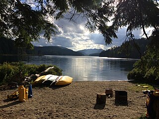
Main Lake Provincial Park is a provincial park on Quadra Island in British Columbia, Canada. Established in 1996 as Main Lakes Chain Park and renamed and expanded in 1997, the park encompasses a large wilderness area of six lakes with many diverse animal, bird and plant species. Opportunities for visitor observation and outdoor recreation include wilderness camping, canoeing, kayaking and hiking. Main Lake, Village Bay Lake and Mine Lake are connected by narrow, shallow marshes. Clear Lake, Stramberg Lake and Little Main Lake are accessible by hiking or rough portage.

Rebecca Spit Marine Provincial Park is a provincial park in British Columbia, Canada, located on the east side of Quadra Island, near the city of Campbell River.
Winter Harbour is the western-most settlement on the west coast about 41 kilometres (25 mi) from the northwest tip of Vancouver Island, British Columbia. This unincorporated community on Winter Harbour is on the northern side of Quatsino Sound at the mouth.
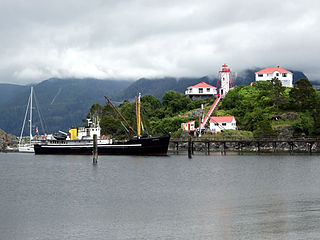
Yuquot, also known as Friendly Cove, is a small settlement of around six people—the Williams family of the Mowachaht band—plus two full-time lighthouse keepers, located on Nootka Island in Nootka Sound, just west of Vancouver Island, British Columbia, Canada. It was the summer home of Chief Maquinna and the Mowachaht/Muchalaht (Nuu-chah-nulth) people for generations, housing approximately 1,500 people in 20 traditional wooden longhouses. The name means "Wind comes from all directions" in Nuu-chah-nulth.
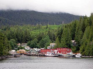
Telegraph Cove is a community of about 20 inhabitants, on Vancouver Island in British Columbia, Canada, located approximately 210 kilometres (130 mi) northwest of Campbell River. It is a former milling and cannery village that has become a launch point for eco-tourism. It is three kilometers southeast of Beaver Cove.

Cortes Island is an island in the Discovery Islands archipelago on the coast of British Columbia, Canada. The island is 25 km (16 mi) long, 13 km (8 mi) wide, and 130 km2 (50 sq mi) in area. It has a population of 1,035 permanent residents. Cortes Island lies within Electoral Area B of the Strathcona Regional District, which provides water and sewage systems, fire protection, land use planning, parks, recreation, and emergency response.
The ƛoʔos Klahoose are one of the three groups comprising the ʔayʔaǰuθəm Tla'Amin or Mainland Comox. The other two divisions of this once-populous group are the χʷɛmaɬku Homalco and Sliammon. The Klahoose, Homalco and Sliammon are, according to oral tradition, the descendants of the survivors of the Great Flood. The three groups were split by colonialism into different band councils but united historically as the Tla A'min, known as the Mainland Comox, and K’ómoks, the larger grouping of the Comox people, also known as the Island Comox and before the merger with the Laich-kwil-tach culture. Historically both groups are a subgroup of the Coast Salish though the K’ómoks name is from, and their language today, is the Lik'wala dialect of Kwak'wala. The ancestral tongue is the Comox language, though the Sahtloot/Island dialect is extinct.

Read Island is an island in British Columbia, Canada. It is part of the Discovery Islands between Vancouver Island and the mainland, between the Strait of Georgia and Johnstone Strait.
Heriot Bay is the principal settlement on Quadra Island in British Columbia, Canada.
Comox Land District is one of the 59 land districts of British Columbia, Canada, which are part of the cadastral divisions of British Columbia, created with rest of those on Vancouver Island via the Lands Act of the Colony of Vancouver Island. The British Columbia government's BC Names system, a subdivision of GeoBC, defines a land district as "a territorial division with legally defined boundaries for administrative purposes". All land titles and surveys use the Land District system as the primary point of reference, and entries in BC Names for placenames and geographical objects are so listed.
Englewood was a community located at the head of Beaver Cove on Northern Vancouver Island, British Columbia, Canada. Beaver Cove is on the south side of the Johnstone Strait, between Robson Bight and Port McNeill. The mouth of the Kokish River is to the southeast of the former site of Englewood.
