
Northampton is a large market town, civil parish non-metropolitan district and the county town of Northamptonshire in the East Midlands region of England. It lies on the River Nene, 60 miles (97 km) north-west of London and 50 miles (80 km) south-east of Birmingham. It's one of the largest towns in England, it had a population of 212,100 at the 2011 census.

Northamptonshire, archaically known as the County of Northampton, is a county in the East Midlands of England. In 2015 it had a population of 723,000. The county is administered by Northamptonshire County Council and by seven non-metropolitan district councils. It is known as "The Rose of the Shires".

The city of Northampton is the county seat of Hampshire County, Massachusetts, United States. As of the 2010 census, the population of Northampton was 28,549.

Market Harborough is a market town within the Harborough district of Leicestershire, England. It is situated in the far southeast of the county, forming part of the border with Northamptonshire.

Daventry is a market town and civil parish in western Northamptonshire, England, close to the border with Warwickshire. At the 2011 Census Daventry had a population of 25,026, making it the sixth largest town in Northamptonshire. It is the administrative centre of the larger Daventry District, which had a population of 78,070 at the 2011 census.

Boughton is a village and civil parish in the Daventry district of Northamptonshire, England, about 4 miles (6.4 km) from Northampton town centre along the A508 road between Northampton and Market Harborough. The parish area straddles both side of the road but the main part of the village is east. It is on the northern fringe of the Northampton urban area and, together with the neighbouring village of Moulton is in the preferred area for the expansion of the town.

Wootton is a former village about 3 miles (4.8 km) south of Northampton town centre that is now part of the Northampton Borough Council area.

Weston Favell is an area near the eastern end of Northampton, and is part of Park ward of the Borough of Northampton.

The University of Northampton is a public university based in Northampton, Northamptonshire, England. It was formed in 1999 by the amalgamation of a number of training colleges, and gained full university status as the University of Northampton in 2005.
Abington is a district of the town of Northampton, Northamptonshire, England, situated about 2 miles (3.2 km) east of the town centre. The population of the ward of Northampton Borough Council at the 2011 census was 9,668.
Hardingstone is a village in Northamptonshire, England. It is on the southern edge of Northampton, and now forms a suburb of the town within the Northampton Borough Council area. It is about 1 mile (2 km) from the town centre. The Newport Pagnell road separates the village from the nearby village of Wootton, which has also been absorbed into the urban area.

East Hunsbury is a large residential area in the south of the town of Northampton, England, 3 miles (5 km) from the town centre and 1 mile (2 km) from the M1 motorway, junction 15. For administrative purposes it is part of the Borough of Northampton. It is part of the Hunsbury residential area, which also includes West Hunsbury on the west side of Towcester Road. Shelfleys is the original name for the area of Northampton currently referred to as West Hunsbury. The name of West Hunsbury still appears on maps for the district as Shelfleys. Merefield is the corresponding name for East Hunsbury, together with the name "Blackymore" for the eastern part of East Hunsbury. All three names are still on local direction signs in Northampton, although older references are no longer in use by the local people living there. The areas developed in the 1980s and 1990s as part of the expansion of Northampton. The Northampton loop of the West Coast Main Line railway running between Northampton and London Euston runs under East and West Hunsbury via the Hunsbury Hill Tunnel emerging near Hill Farm Rise which follows the original course of Towcester Road prior to the 1980s. Ventilation shafts are visible in the housing estate in Yeoman Meadow.

The Shire of Northampton is a local government area in the Mid West region of Western Australia, about 50 kilometres (30 mi) north of Geraldton and about 460 kilometres (290 mi) north of the state capital, Perth. The Shire covers an area of 13,738 square kilometres (5,304 sq mi), and its seat of government is the town of Northampton, with the largest settlement being Kalbarri.
Far Cotton is a district in the civil parish of Far Cotton and Delapre, in the town of Northampton, in the county of Northamptonshire, England and many years ago a village in its own right. The population is included in the Delapre and Briar Hill Ward of Northampton Borough Council.

The Northampton Carnival has had strong traditions in the town from the 1960s through the Midsummer Meadow times in the 1980s, to its short break in the late 1990s, until its revival in 2005.
Richard Wilfred Hill is an English football coach and manager. He is also a former footballer who played for Oxford United, Watford, Northampton Town and Leicester City. He has been assistant manager at six different clubs, including Queens Park Rangers, and had a difficult but successful stint as manager of Stevenage Borough before taking Eastleigh into the Conference for the first time in their history.

The Northampton Street Tramways Company operated a horse powered tramway service in Northampton between 1881 and 1901.

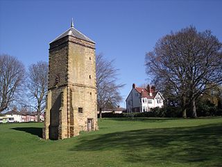
The Racecourse is an open space park situated in the centre of Northampton. The park is surrounded by the Mounts, Kingsley and Semilong estates. Due to the historical links of the Racecourse to Northampton's history, it remains one of the town's famous landmarks. As implied by its name, the Racecourse once staged regular horse racing meetings, however, these ceased in 1904 due to a high number of accidents, which included fatalities, caused by the sharpness of the track.

St. James End also known as simply St. James and historically St James's End is a district west of the town centre in Northampton, England. The area developed from the mid to late 19th century particularly with the expansion of the shoe manufacturing and engineering industries, and also the extension of the railway from London in June 1882.

