
The Orange River is a river in Southern Africa. It is the longest river in South Africa. With a total length of 2,432 km (1,511 mi), the Orange River Basin extends from Lesotho into South Africa and Namibia to the north. It rises in the Drakensberg mountains in Lesotho, flowing westwards through South Africa to the Atlantic Ocean. The river forms part of the international borders between South Africa and Lesotho and between South Africa and Namibia, as well as several provincial borders within South Africa. Except for Upington, it does not pass through any major cities. The Orange River plays an important role in the South African economy by providing water for irrigation and hydroelectric power. The river was named the Orange River in honour of the Dutch ruling family, the House of Orange, by the Dutch explorer Robert Jacob Gordon. Other names include simply the word for river, in Khoekhoegowab orthography written as !Garib, which is rendered in Afrikaans as Gariep River with the intrusion of a velar fricative in place of the alveolar click, Groote River or Senqu River, derived from ǂNū "Black". It is known in isiZulu as isAngqu.

The Northern Cape is the largest and most sparsely populated province of South Africa. It was created in 1994 when the Cape Province was split up. Its capital is Kimberley. It includes the Kalahari Gemsbok National Park, part of the Kgalagadi Transfrontier Park and an international park shared with Botswana. It also includes the Augrabies Falls and the diamond mining regions in Kimberley and Alexander Bay.

Upington is a town founded in 1873 and located in the Northern Cape province of South Africa, on the banks of the Orange River. The town was originally called Olijvenhoutsdrift, due to the abundance of olive wood trees in the area, but later renamed after Sir Thomas Upington, Attorney-General and then Prime Minister of the Cape. It originated as a mission station established in 1871 and run by Reverend Christiaan Schröder. The mission station now houses the Kalahari Orange Museum. The museum is also the home of a donkey statue, which recognises the enormous contribution that this animal made to the development of the region during the pioneering days of the 19th century.

The N1 is a national route in South Africa that runs from Cape Town through Bloemfontein, Johannesburg, Pretoria and Polokwane to Beit Bridge on the border with Zimbabwe. It forms the first section of the famed Cape to Cairo Road.

The R27 is a provincial route in South Africa that consists of two disjoint segments. The first segment, also known as the West Coast Highway, connects Cape Town with Velddrif along the West Coast. The second runs from Vredendal via Vanrhynsdorp, Calvinia, Brandvlei and Kenhardt to Keimoes on the N14 near Upington. The connection between Velddrif and Vredendal has never been built, although it can be driven on various gravel roads.

The R28 is a provincial route in Gauteng, South Africa that connects Krugersdorp with Vereeniging via Randfontein. The R28 used to connect with Pretoria, but that section of the road is now part of the N14.

The R55 is a north-south provincial route in Gauteng, South Africa that connects Sandton with Pretoria. It passes Woodmead, Kyalami, Olievenhoutbosch, Heuweloord, Sunderland Ridge, Erasmia, Laudium/Claudius, West Park, the Daspoort Tunnel and Danville. It connects with the M1, N14, and R80 highways. It is also designated as the P66-1 and K71 by the Gauteng Provincial Government.
The R360 is a Regional Route in the Northern Cape of South Africa that connects Upington with the Kalahari Gemsbok National Park and the Namibian border. It passes through Askham and Andriesvale.
The R385 is a regional route in South Africa that connects Olifantshoek with Hopetown via Postmasburg and Douglas.
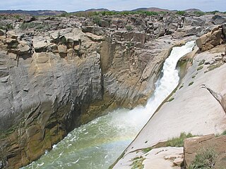
Augrabies Falls National Park is a national park located around the Augrabies Falls, about 120 km west of Upington in the Northern Cape Province, South Africa.

The N12 is a national route in South Africa which runs from George through Beaufort West, Kimberley, Klerksdorp and Johannesburg to eMalahleni.

The N8 is a national route in South Africa that connects Groblershoop with Maseru in Lesotho via Kimberley and Bloemfontein. It is maintained by the South African National Roads Agency.

Pofadder is a small town in the Northern Cape province of South Africa. In spite of its small size, it is an important local centre in the region known in South Africa as Bushmanland. The surrounding districts are arid, sparsely populated, rugged and picturesque. There is little in the way of cropping and local farmers run sheep or goats for a living. As a tourist destination, it is not sufficiently spectacular to rival the spring flowers of the coastal regions of Namaqualand, but it has its attractions for biologists and conservationists and those with an interest in its remarkable diversity of often-tiny xerophytes and animal life. In recent years, the town economy has been boosted by the construction and operation of solar power stations.

Kakamas is a town founded in 1898 and located in the Northern Cape province of South Africa, on the banks of the Orange River.

The N10 is a national route in South Africa connecting Gqeberha on the Eastern Cape coast with the Namibian border at Nakop, via Cradock, De Aar and Upington.

The N14 is a national route in South Africa which runs from Springbok in the Northern Cape to Pretoria in Gauteng. It passes through Upington, Kuruman, Vryburg, Krugersdorp and Centurion. The section between Pretoria and Krugersdorp is maintained by the Gauteng Provincial government and is also designated the P158.

//Khara Hais Local Municipality was a local municipality in the Northern Cape province of South Africa. It fell within the ZF Mgcawu District Municipality and governed the town of Upington and surrounding rural areas. As of 2011 the municipality had a population of approximately 93,500 people, and covered an area of 21,780 square kilometres (8,410 sq mi). The unusual spelling of the name comes from the original transcription of the Khwe language name, where the click consonant became "//".
Augrabies is a small town in the Northern Cape province of South Africa, situated on the south bank of the Orange River about 100 kilometres (60 mi) downstream from Upington. It is located on the R359 road just outside the Augrabies Falls National Park, which contains the Augrabies Falls for which the town is named.
The R505 is a Regional Route in South Africa. It connects Ottoshoop, North West Province in the north with Wesselsbron, Free State Province to the south.
The R114 is a regional route in Gauteng, South Africa that runs from Muldersdrift to Centurion. The designation R114 is applied to sections of road that were previously part of the N14 that have been replaced by newly built freeway sections.
