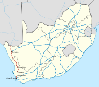
The R358 is a Regional Route in South Africa that connects the N7 north of Bitterfontein with the Namibian border at Onseepkans via Pofadder. [1]
Contents
 | ||||
|---|---|---|---|---|
| Location | ||||
| Country | South Africa | |||
| Highway system | ||||
| ||||
The R358 is a Regional Route in South Africa that connects the N7 north of Bitterfontein with the Namibian border at Onseepkans via Pofadder. [1]
| | ||||
|---|---|---|---|---|
| Location | ||||
| Country | South Africa | |||
| Highway system | ||||
| ||||
Starting from the N7 it heads north-east. It meets the R355 from the south-east and the two become co-signed. The routes cross into the Northern Cape before again diverging. Continuing north-east it reaches Pofadder after some 230 kilometres. Here it meets the N14 at a staggered junction. Leaving the town, it heads north to its terminus at Velloorsdrif Border Post at Onseepkans. Heading north into Namibia, the route continues as the C10. [1]

Namaqualand is an arid region of Namibia and South Africa, extending along the west coast over 1,000 km (600 mi) and covering a total area of 440,000 km2 (170,000 sq mi). It is divided by the lower course of the Orange River into two portions – Little Namaqualand to the south and Great Namaqualand to the north.

National routes in South Africa are a class of trunk roads and freeways which connect major cities. They form the highest category in the South African route numbering scheme, and are designated with route numbers beginning with "N", from N1 to N18. Most segments of the national route network are officially proclaimed National Roads that are maintained by the South African National Roads Agency (SANRAL), but some segments are maintained by provincial or local road authorities.

The N1 is a national route in South Africa that runs from Cape Town through Bloemfontein, Johannesburg, Pretoria and Polokwane to Beit Bridge on the border with Zimbabwe. It forms the first section of the famed Cape to Cairo Road.

The R27 is a provincial route in South Africa that consists of two disjoint segments. The first segment, also known as the West Coast Highway, connects Cape Town with Velddrif along the West Coast. The second runs from Vredendal via Vanrhynsdorp, Calvinia, Brandvlei and Kenhardt to Keimoes on the N14 near Upington. The connection between Velddrif and Vredendal has never been built, although it can be driven on various gravel roads.

The R45 is a provincial route in Western Cape, South Africa that connects Saldanha with Villiersdorp via Vredenburg, Malmesbury and Paarl. The route is mostly a two-lane wide-shouldered highway, however sections within Paarl and between Vredenburg and Saldanha are dual-carriageways. The R45 is co-signed with the N7 for a short segment north of Malmesbury.
The R304 is a Regional Route in South Africa that connects Stellenbosch with Atlantis.
The R355 is a Regional Route in South Africa that connects the R46 near Ceres with Kleinsee via Calvinia and Springbok.
The R362 is a Regional Route in South Africa that connects Strandfontein with the N7 at Klawer.
The R363 is a Regional Route in South Africa that connects Nuwerus on the N7 and Klawer, also on the N7, via Vredendal.
The R399 is a Regional Route in South Africa that connects Vredenburg with the N7 between Piketberg and De Hoek.

The Walvis Bay-Ndola-Lubumbashi Development Road, formerly known as the Trans-Caprivi Corridor and until 2004 the Trans-Caprivi Highway, begins in Walvis Bay. It runs through Rundu in northeastern Namibia and along the Caprivi Strip to Katima Mulilo on the Zambezi River, which forms the border between Namibia and Zambia. The Katima Mulilo Bridge spans the river to the Zambian town of Sesheke. From there, the road continues as the M10 Road to Livingstone, where it connects to the main north–south highway to Lusaka and extends to the Copperbelt.
The N7 is a national route in South Africa that runs from Cape Town northwards through the West Coast and Namaqualand regions to the Namibian border at Vioolsdrif. It is known as the Cape Namibia Road. After crossing the border, it changes designation to B1 and runs north through Windhoek and the north of Namibia.
Onseepkans is a small settlement on the banks of the Orange River in Northern Cape Province, South Africa. It is a border post with Namibia for traffic between Pofadder in South Africa and Keetmanshoop in Namibia. The name either originated from a combination of three Nama words: ‘tconsiep’, ‘nias’, and ‘tcaans’ (thorntrees), or a derivative of a nama word that means 'watering place for cattle'.
The Tripoli–Cape Town Highway or TAH 3 is Trans-African Highway 3 in the transcontinental road network being developed by the United Nations Economic Commission for Africa (UNECA), the African Development Bank (AfDB), and the African Union. The route has a length of 10,808 km (6,716 mi) and has the longest missing links and requires the most new road construction.

Pofadder is a small town in the Northern Cape province of South Africa. In spite of its small size, it is an important local centre in the region known in South Africa as Bushmanland. The surrounding districts are arid, sparsely populated, rugged and picturesque. There is little in the way of cropping and local farmers run sheep or goats for a living. As a tourist destination, it is not sufficiently spectacular to rival the spring flowers of the coastal regions of Namaqualand, but it has its attractions for biologists and conservationists and those with an interest in its remarkable diversity of often-tiny xerophytes and animal life. In recent years, the town economy has been boosted by the construction and operation of solar power stations.

The N10 is a national route in South Africa connecting Gqeberha on the Eastern Cape coast with the Namibian border at Nakop, via Cradock, De Aar and Upington.
The A2 highway is a road in Botswana running from the Namibian border at Buitepos through Jwaneng, Kanye and Lobatse to the South African border at Pioneer Gate, thus connecting 3 countries.
The B1 is a national highway of Namibia, and is the country's longest and most significant road, running the length of the country from south to north. It connects Noordoewer in the south on the South African border with Oshikango in the north on the Angolan border via Namibia's capital city Windhoek.

The N14 is a national route in South Africa which runs from Springbok in the Northern Cape to Pretoria in Gauteng. It passes through Upington, Kuruman, Vryburg, Krugersdorp and Centurion. The section between Pretoria and Krugersdorp is maintained by the Gauteng Provincial government and is also designated the P158.

Vanrhynsdorp is a town located in the West Coast District Municipality of the Western Cape province in South Africa. Considered the oldest and most southern European-settled town in Namaqualand, Vanrhynsdorp serves as a gateway to the Succulent Karoo and Nama Karoo regions to the north and east.
| | This South African road or road transport-related article is a stub. You can help Wikipedia by expanding it. |
