
The N1 is a national route in South Africa that runs from Cape Town through Bloemfontein, Johannesburg, Pretoria and Polokwane to Beit Bridge on the border with Zimbabwe. It forms the first section of the famed Cape to Cairo Road.

The Swartberg mountains are a mountain range in the Western Cape province of South Africa. It is composed of two main mountain chains running roughly east–west along the northern edge of the semi-arid Little Karoo. To the north of the range lies the other large semi-arid area in South Africa, the Great Karoo. Most of the Swartberg Mountains are above 2000 m high, making them the tallest mountains in the Western Cape. It is also one of the longest, spanning some 230 km from south of Laingsburg in the west to between Willowmore and Uniondale in the east. Geologically, these mountains are part of the Cape Fold Belt.

The R61 is a long provincial route in South Africa that connects Beaufort West with Port Shepstone via Graaff-Reinet, Komani, Mthatha and Port Edward.

The R63 is a tarred provincial route in South Africa that connects Calvinia with Komga via Carnarvon, Victoria West, Graaff-Reinet, Somerset East and King William's Town. It is cosigned with the N10 between Eastpoort and Cookhouse for 24 kilometres.

The R75 is a provincial route in Eastern Cape, South Africa that connects Graaff-Reinet with Gqeberha via Despatch, Kariega and Jansenville.

The R80 is a provincial route in the City of Tshwane Metropolitan Municipality in Gauteng, South Africa that connects the Pretoria CBD with Mabopane and Soshanguve. It is a dual carriageway freeway, with 2 or 3 lanes in each direction at different points and is named the Mabopane Highway.

The R102 is a Regional Route in South Africa. It is the route designation for all old sections of the N2, thus it is a discontinuous road that resumes in areas where a new N2 has been constructed.
The R307 is a Regional Route in South Africa that connects the R27 north of Melkbosstrand with the R45 south-west of Moorreesburg.
The R340 is a Regional Route in South Africa that connects the N2 at Keurboomsrivier near Plettenberg Bay in the south-east with the R339.

The N2 is a national route in South Africa that runs from Cape Town through George, Gqeberha, East London, Mthatha, Port Shepstone and Durban to Ermelo. It is the main highway along the Indian Ocean coast of the country. Its current length of 2,255 kilometres (1,401 mi) makes it the longest numbered route in South Africa.

Uniondale is a small town in the Little Karoo in the Western Cape Province, South Africa. The town was formed in 1856 by the joining of two towns, Hopedale and Lyons. Its primary claim to fame is the ghost story of the Uniondale hitcher. The town is connected by the N9 road and the R339 road.
The Langkloof is a 160 km-long (99 mi) valley in South Africa, lying between Herold, a small village northeast of George, and The Heights – just beyond Twee Riviere.

The Outeniqua Mountains, named after the Outeniqua Khoikhoi who lived there, is a mountain range that runs a parallel to the southern coast of South Africa, and forms a continuous range with the Langeberg to the west and the Tsitsikamma Mountains to the east. It was known as Serra de Estrella to the Portuguese. The mountains are part of the Garden Route of South Africa.

The N9 is a national route in South Africa that connects George with the N1 at Colesberg, via Graaff-Reinet and Middelburg.

The R62 is a provincial route in South Africa that connects Ashton with Humansdorp. The R62 runs through the Little Karoo and the Langkloof, passing through Montagu, Ladismith, Calitzdorp, Oudtshoorn, and Joubertina.
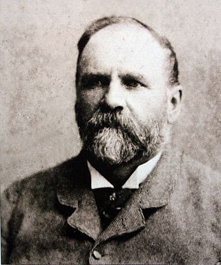
Thomas Charles John Bain was a South African road engineer. As a prolific road building pioneer, Bain was responsible for the planning and construction of more than 900 km of roads and mountain passes, many of them still in use today, over a career spanning from 1848 until 1888. These passes through the mountain ranges between the thin coastal plain and the interior of the former Cape Colony in South Africa, played a major role in opening up the vast hinterland of South Africa.

Buyspoort Pass, is a mountain pass located in the Eastern Cape province of South Africa on the N9 national route between Uniondale and Willowmore. Its name derives from the surname Buys and poort, the Afrikaans word for gate.

Avontuur is a town situated in the Garden Route District Municipality in the Western Cape province of South Africa. The town is located 13km south-east of Uniondale on an intersection of the R339 and R62 regional routes.
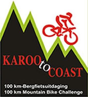
The Karoo to Coast is an annual 100 km mountain bike race held in September down the Prince Alfred's Pass from Uniondale to Knysna in South Africa. In 2007 it was voted one of the top ten mountain bike races in the country. All proceeds from the race go to the Lions Clubs International SightFirst program for sight restoration surgery for the poor.
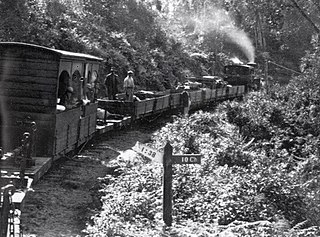
The South Western Railway Co. Ltd., Also called Knysna Forest Railway, was a 2 ft narrow gauge forest railway in the southern Cape Province in South Africa. The line connected the port of Knysna with sawmills in the Tsitsikamma Forest and had a length of 31 kilometers. The railway was in operation between 1907 and 1949.


