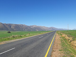
The R366 is a Regional Route in South Africa that connects Elands Bay in the north-west with the R365, and indirectly, Piketberg and the N7. [1]
Contents
 | ||||
|---|---|---|---|---|
| Location | ||||
| Country | South Africa | |||
| Highway system | ||||
| ||||
The R366 is a Regional Route in South Africa that connects Elands Bay in the north-west with the R365, and indirectly, Piketberg and the N7. [1]
| | ||||
|---|---|---|---|---|
| Location | ||||
| Country | South Africa | |||
| Highway system | ||||
| ||||
Starting in Elands Bay it runs south-east along the north bank of the Verlorenvlei River. After 28 kilometres, it passes Redelinghuys on the right. After a further 21 kilometres, it crosses the Kruismans River. It then veers east to end at a t-junction with the R365 after five kilometres. If you continue straight at the t-junction, you veer South towards Piketberg on R365. The turn-off north also continues as the R365, heading north-north-west to Leipoldtville and Lamberts Bay. [1]

Cederberg Municipality is a local municipality which governs an area of the Western Cape province of South Africa stretching from the Cederberg mountains through the middle valley of the Olifants River to the Atlantic coast. It includes the towns of Clanwilliam, Citrusdal and Lamberts Bay, and the surrounding villages and farms. As of 2011 it had a population of 49,768. It is located within the West Coast District Municipality and its municipality code is WC012.

The R27 is a provincial route in South Africa that consists of two disjoint segments. The first segment, also known as the West Coast Highway, connects Cape Town with Velddrif along the West Coast. The second runs from Vredendal via Vanrhynsdorp, Calvinia, Brandvlei and Kenhardt to Keimoes on the N14 near Upington. The connection between Velddrif and Vredendal has never been built, although it can be driven on various gravel roads.

The R33 is a provincial route in South Africa that connects Pietermaritzburg with Lephalale via Greytown, Paulpietersburg, Carolina, Belfast and Vaalwater. It is a very long road, passing through 3 provinces.

The R34 is a long provincial route in South Africa that connects Vryburg with Richards Bay via Kroonstad and Newcastle. It passes through three provinces, North West, the Free State and KwaZulu-Natal.

The R36 is a provincial route in South Africa that connects the N1 at Bandelierkop with Ermelo, via Tzaneen and Lydenburg. It is co-signed with the N4 for 8 kilometres between Machadodorp and Patattanek, with a tollgate on this section. It used to extend further south past Ermelo to Amersfoort, but that section is now designated as part of the N11.

The R44 is a provincial route in Western Cape, South Africa that connects Piketberg with Kleinmond via Wellington, Stellenbosch, Somerset West and Strand. The coastal section between Kleinmond and Gordon's Bay is a very scenic ocean drive. The section between Gordon's Bay and Stellenbosch via Strand and Somerset West is a dual carriageway. The R44 is co-signed with the R46 between Gouda and Hermon in the Berg River valley.

The R45 is a provincial route in Western Cape, South Africa that connects Saldanha with Villiersdorp via Vredenburg, Malmesbury and Paarl. The route is mostly a two-lane wide-shouldered highway, however sections within Paarl and between Vredenburg and Saldanha are dual-carriageways. The R45 is co-signed with the N7 for a short segment north of Malmesbury.

The R59 is a provincial route in South Africa that connects Hertzogville with Alberton via Bothaville, Parys and Vereeniging. The R59 is a freeway from the R57 Junction in Sasolburg until the N12 Reading Interchange in Alberton, signposted as the Sybrand van Niekerk Freeway.

The R63 is a tarred provincial route in South Africa that connects Calvinia with Komga via Carnarvon, Victoria West, Graaff-Reinet, Somerset East and King William's Town. It is cosigned with the N10 between Eastpoort and Cookhouse for 24 kilometres.

The R82 is a provincial route in South Africa that connects Johannesburg with Kroonstad via Vereeniging and Sasolburg. It starts just south of the M1 Johannesburg Municipal Highway's interchange with the N12 Southern Bypass, going south, meeting the R59, R54, R42 & R28 routes at Vereeniging before crossing the Vaal River into the Free State & proceeding to Kroonstad. It is an alternative, but longer route to the N1 national route between Johannesburg & Kroonstad.
The R318 is a Regional Route in Western Cape, South Africa that connects the N1 between De Doorns and Touws River in the north-west with Montagu in the south-east via the Koo and Keisie Valleys.
The R364 is a Regional Route in South Africa that connects Lamberts Bay to the R27 between Calvinia and Nieuwoudtville via Clanwilliam.
The R365 is a Regional Route in South Africa that connects Piketberg and Lamberts Bay.
The R399 is a Regional Route in South Africa that connects Vredenburg with the N7 between Piketberg and De Hoek.

The Walvis Bay-Ndola-Lubumbashi Development Road, formerly known as the Trans-Caprivi Corridor and until 2004 the Trans-Caprivi Highway, begins in Walvis Bay. It runs through Rundu in northeastern Namibia and along the Caprivi Strip to Katima Mulilo on the Zambezi River, which forms the border between Namibia and Zambia. The Katima Mulilo Bridge spans the river to the Zambian town of Sesheke. From there, the road continues as the M10 Road to Livingstone, where it connects to the main north–south highway to Lusaka and extends to the Copperbelt.

The N12 is a national route in South Africa which runs from George through Beaufort West, Kimberley, Klerksdorp and Johannesburg to eMalahleni.

The N4 is a national route in South Africa that runs from Skilpadshek on the Botswana border, past Rustenburg, Pretoria, eMalahleni and Mbombela, to Komatipoort on the Mozambique border. The entire route is a toll road.

The N17 is a national route in South Africa which runs from Johannesburg to Oshoek (Ngwenya) on the border with Eswatini. It passes through Springs, Bethal and Ermelo.

Redelinghuys is a village in the Bergrivier Local Municipality in the Western Cape province of South Africa, located about 160 kilometres (100 mi) north of Cape Town on the Verlorevlei River. The 2001 Census recorded the population as 581 people in 167 households. The village is situated on the R366 regional route between Piketberg and Elands Bay. It is served by a police station, a public library, a satellite health clinic, and two primary schools.

The M9 is a long metropolitan route in the City of Cape Town, South Africa. It connects Sir Lowry's Pass Village with Wynberg via Somerset West, Firgrove, Macassar, Khayelitsha and Nyanga.
| | This South African road or road transport-related article is a stub. You can help Wikipedia by expanding it. |
