This article relies largely or entirely on a single source .(March 2022) |
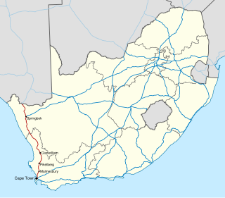
The R399 is a Regional Route in South Africa that connects Vredenburg with the N7 between Piketberg and De Hoek. [1]
Contents
 | ||||
|---|---|---|---|---|
| Location | ||||
| Country | South Africa | |||
| Highway system | ||||
| ||||
This article relies largely or entirely on a single source .(March 2022) |
The R399 is a Regional Route in South Africa that connects Vredenburg with the N7 between Piketberg and De Hoek. [1]
| | ||||
|---|---|---|---|---|
| Location | ||||
| Country | South Africa | |||
| Highway system | ||||
| ||||
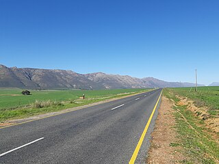
An east–west route, its western terminus is a four-way intersection with the R45 in Vredenburg. The R45 enters from the south (from Saldanha) and turns right, heading east towards Hopefield. Meanwhile, the northern road becomes the R399. It exits Vredenburg heading northeast for 20 kilometres where it meets the R27. These two roads are co-signed heading north for two kilometres, crossing the Berg River and entering Velddrif. At a four-way intersection in Velddrif, the R399 leaves heading east. It continues for 59 kilometres until a T-junction near De Hoek. The northern route is unsigned and continues to Piketberg while the south route is signed as the R399 ending at the N7. [1]

The N1 is a national route in South Africa that runs from Cape Town through Bloemfontein, Johannesburg, Pretoria and Polokwane to Beit Bridge on the border with Zimbabwe. It forms the first section of the famed Cape to Cairo Road.

The R27 is a provincial route in South Africa that consists of two disjoint segments. The first segment, also known as the West Coast Highway, connects Cape Town with Velddrif along the West Coast. The second runs from Vredendal via Vanrhynsdorp, Calvinia, Brandvlei and Kenhardt to Keimoes on the N14 near Upington. The connection between Velddrif and Vredendal has never been built, although it can be driven on various gravel roads.

The R37 is a provincial route in South Africa that connects Polokwane with Mbombela via Burgersfort and Lydenburg (Mashishing).

The R44 is a provincial route in Western Cape, South Africa that connects Piketberg with Kleinmond via Wellington, Stellenbosch, Somerset West and Strand. The coastal section between Kleinmond and Gordon's Bay is a very scenic ocean drive. The section between Gordon's Bay and Stellenbosch via Strand and Somerset West is a dual carriageway. The R44 is co-signed with the R46 between Gouda and Hermon in the Berg River valley.

The R45 is a provincial route in Western Cape, South Africa that connects Saldanha with Villiersdorp via Vredenburg, Malmesbury and Paarl. The route is mostly a two-lane wide-shouldered highway, however sections within Paarl and between Vredenburg and Saldanha are dual-carriageways. The R45 is co-signed with the N7 for a short segment north of Malmesbury.

The R59 is a provincial route in South Africa that connects Hertzogville with Alberton via Bothaville, Parys and Vereeniging. The R59 is a freeway from the R57 Junction in Sasolburg until the N12 Reading Interchange in Alberton, signposted as the Sybrand van Niekerk Freeway.
The R302 is a Regional Route in South Africa that connects Bellville with Malmesbury. It covers a distance of 54 kilometres (34 mi) in a north-south direction.
The R304 is a Regional Route in South Africa that connects Stellenbosch with Atlantis.
The R307 is a Regional Route in South Africa that connects the R27 north of Melkbosstrand with the R45 south-west of Moorreesburg.
The R311 is a Regional Route in South Africa that connects the R45 between Malmesbury and Hopefield to the north-west with Riebeek-Kasteel to the south-east.
The R355 is a Regional Route in South Africa that connects the R46 near Ceres with Kleinsee via Calvinia and Springbok.
The R358 is a Regional Route in South Africa that connects the N7 north of Bitterfontein with the Namibian border at Onseepkans via Pofadder.
The R365 is a Regional Route in South Africa that connects Piketberg and Lamberts Bay.
The R366 is a Regional Route in South Africa that connects Elands Bay in the north-west with the R365, and indirectly, Piketberg and the N7.
The N7 is a national route in South Africa that runs from Cape Town northwards through the West Coast and Namaqualand regions to the Namibian border at Vioolsdrif. It is known as the Cape Namibia Road. After crossing the border, it changes designation to B1 and runs north through Windhoek and the north of Namibia.
Malmesbury is a town of approximately 36,000 inhabitants in the Western Cape province of South Africa, about 65 km north of Cape Town.

The N14 is a national route in South Africa which runs from Springbok in the Northern Cape to Pretoria in Gauteng. It passes through Upington, Kuruman, Vryburg, Krugersdorp and Centurion. The section between Pretoria and Krugersdorp is maintained by the Gauteng Provincial government and is also designated the P158.
The R101 is a Regional Route in South Africa that is the designation for some of the old sections of roads that were previously the N1, prior to upgrading. It only has 2 sections, from Bellville to Worcester and from Johannesburg to Polokwane.
The R301 is a regional route in the Western Cape province of South Africa that connects Wemmershoek with Wolseley via Paarl and Wellington.
Wittewater is a town in Bergrivier Local Municipality in the Western Cape province of South Africa, located off the R399 road, between Piketberg and Velddrif. It was established in the 1857 by German Moravian missionaries.
| | This South African road or road transport-related article is a stub. You can help Wikipedia by expanding it. |
