Witzenberg Municipality is a local municipality located within the Cape Winelands District Municipality, in the Western Cape province of South Africa. As of 2022 it had a population of 103,765.

The R43 is a provincial route in the Western Cape province of South Africa which connects Ceres with Gansbaai via Worcester, Botrivier and Hermanus. It is co-signed with the N2 for nine kilometres near Botrivier.
The R355 is a Regional Route in South Africa that connects the R46 near Ceres with Kleinsee via Calvinia and Springbok.

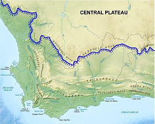
The Cape Fold Belt is a fold and thrust belt of late Paleozoic age, which affected the sequence of sedimentary rock layers of the Cape Supergroup in the southwestern corner of South Africa. It was originally continuous with the Ventana Mountains near Bahía Blanca in Argentina, the Pensacola Mountains, the Ellsworth Mountains and the Hunter-Bowen orogeny in eastern Australia. The rocks involved are generally sandstones and shales, with the shales persisting in the valley floors while the erosion resistant sandstones form the parallel ranges, the Cape Fold Mountains, which reach a maximum height of 2325 m at Seweweekspoortpiek.

The Koue Bokkeveld, meaning "Cold Buck Shrubland" in Afrikaans, is a mountain range in the Western Cape Province, South Africa. Geologically the range is composed of Cedarberg Sandstone of the Cape System.

Romulea is a genus of flowering plants in the family Iridaceae, first described as a genus in 1772. It is found in Europe, the Mediterranean, the Arabian Peninsula, and Africa.

Gydo Pass is situated in the Western Cape, province of South Africa on the Regional road R303 between Ceres and Citrusdal.
The Groot River is a river in the Western Cape Province, South Africa. It is part of the Olifants/Doring River system. It is not to be confused with the Groot River of Eastern Cape or the Groot River of Southern Cape provinces.
The Bloukrans Pass of the Onder-Bokkeveld region, is located on the R355 road between Ceres and Calvinia, in the Northern Cape province of South Africa. It navigates the lower slopes of the Bloukrans Mountain on its eastern shoulder, and has the Nuwewater se berg on its western side. The Bloukrans Mountain is the northern promontory of the Roggeveld Mountains.

Durbaniopsis saga, the Boland rocksitter, is a butterfly of the family Lycaenidae. It is found in South Africa in a wide area in the inland of the Western Cape and Northern Cape mountains, from the Nieuwoudtville mountains south to the Cederberg, Koue Bokkeveld, the Hex River and the Hawequas mountains. It is also present on low altitudes from Lambert's Bay inland to Het Kruis.

Wolseley is a small town in the upper Breede River Valley region of the Western Cape province of South Africa. In the 2011 Census it had a population of 1,528 people. It is located 90 kilometres (60 mi) northeast of Cape Town, in the Land van Waveren valley between the Waterval Mountains to the west and the Witzenberg Mountains to the east.
The Western Province Sport Parachute Club (WPSPC) provides a facility for sports skydiving and student training and is operated and managed on a volunteer basis by a committee elected by its members. The club is a not-for-gain body corporate under common law.
The Riet River is a river in the Western Cape Province, South Africa. It is part of the Olifants/Doring River system.

The Bokkeveld Group is the second of the three main subdivisions of the Cape Supergroup in South Africa. It overlies the Table Mountain Group and underlies the Witteberg Group. The Bokkeveld Group rocks are considered to range between Lower Devonian (Lochkovian) to Middle Devonian (Givetian) in age.

Protea glabra, also called the Clanwilliam sugarbush, is a flowering shrub belonging to the genus Protea.

Protea witzenbergiana, or Swan sugarbush, is a flowering shrub of the genus Protea.

Protea laevis, also known as the smooth-leaf sugarbush, is a flowering shrub that belongs within the genus Protea.

Leucadendron brunioides var. brunioides, the common foetid conebush, is a flower-bearing shrub and variety of Leucadendron brunioides, which belongs to the genus Leucadendron and forms part of the fynbos. The plant is native to the Western Cape where it occurs on the Bokkeveld Carp near Nieuwoudtville, the Sandveld, Gifberg, Cederberg to the eastern Koue Bokkeveld, Hex River Mountains, and the Breede River Valley.
Paranomus lagopus, the rabbit-paw sceptre, is a flower-bearing shrub that belongs to the genus Paranomus and forms part of the fynbos. The plant is native to the Western Cape where it occurs in the Koue Bokkeveld Mountains, Groot-Winterhoek Mountains and Elandskloof Mountain.
Serruria confragosa, the wavy spiderhead, is a flower-bearing shrub that belongs to the genus Serruria and forms part of the fynbos. The plant is native to the Western Cape and occurs in the Koue Bokkeveld Mountains and Great Winterhoek Mountains. The shrub grows upright with few branches and grows 1.0 m tall, and flowers from September to November.


