
Bartolomeu Dias was a Portuguese mariner and explorer. In 1488, he became the first European navigator to round the southern tip of Africa and to demonstrate that the most effective southward route for ships lies in the open ocean, well to the west of the African coast. His discoveries effectively established the sea route between Europe and Asia.

Mossel Bay is a harbour town of about 120,000 people on the Southern Cape of South Africa. It is an important tourism and farming region of the Western Cape Province. Mossel Bay lies 400 kilometres east of the country's seat of parliament, Cape Town, and 400 km west of Port Elizabeth, the largest city in the Eastern Cape. The older parts of the town occupy the north-facing side of the Cape St Blaize Peninsula, whilst the newer suburbs straddle the Peninsula and have spread eastwards along the sandy shore of the Bay.
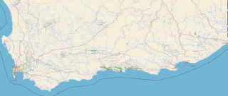
The Garden Route is a 300-kilometre (190 mi) stretch of the south-eastern coast of South Africa which extends from Witsand in the Western Cape to the border of Tsitsikamma Storms River in the Eastern Cape. The name comes from the verdant and ecologically diverse vegetation encountered here and the numerous estuaries and lakes dotted along the coast. It includes towns such as Witsand, Heidelberg, Riversdale, Stilbaai, Albertinia, Gouritsmond, Knysna, Plettenberg Bay, Mossel Bay, Oudtshoorn, Great Brak River, Little Brak River, Wilderness, Sedgefield and Nature's Valley; with George, the Garden Route's largest city and main administrative centre.

Kannaland Municipality is a local municipality located within the Garden Route District Municipality, in the Western Cape province of South Africa. The municipal area is situated in the western part of the Little Karoo and includes the towns of Ladismith, Calitzdorp and Zoar. As of 2022, it has a population of 31,986. Its municipality code is WC041.

The R102 is a Regional Route in South Africa. It is the route designation for all old sections of the N2, thus it is a discontinuous road that resumes in areas where a new N2 has been constructed.
The R323 is a Regional Route in South Africa that connects Riversdale in the south with Laingsburg in the north.
The R328 is a Regional Route in Western Cape, South Africa that connects Mossel Bay in the south to Prince Albert in the north via Oudtshoorn.
The R364 is a Regional Route in South Africa that connects Lamberts Bay to the R27 between Calvinia and Nieuwoudtville via Clanwilliam.

The N2 is a national route in South Africa that runs from Cape Town through George, Gqeberha, East London, Mthatha, Port Shepstone and Durban to Ermelo. It is the main highway along the Indian Ocean coast of the country. Its current length of 2,255 kilometres (1,401 mi) makes it the longest numbered route in South Africa.

The Langeberg Range is a mountain range in the Western Cape province of South Africa. Its highest peak is Keeromsberg at 2,075 m that lies 15 km northeast of the town of Worcester. Some of the highest peaks of the range are located just to the north of Swellendam, in a subrange known as the Clock Peaks whose highest point is the 1,710 m high Misty Point. Local lore states one can tell the time by means of the shadows cast by the seven summits of the Clock Peaks.

The EB Cloete Interchange, officially called the Abdullah Mohamed Omar Interchange, near Durban in South Africa is the interchange between two national roads that pass through Durban: the N2 and N3. The only four-level stack interchange in South Africa has been given various nicknames, the most famous one is Spaghetti Junction.

John Hutchinson, OBE, FRS was an English botanist, taxonomist and author.

The R62 is a provincial route in South Africa that connects Ashton with Humansdorp. The R62 runs through the Little Karoo and the Langkloof, passing through Montagu, Ladismith, Calitzdorp, Oudtshoorn, and Joubertina.
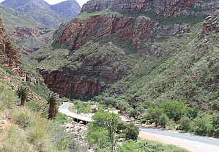
Meiringspoort is a South African mountain pass on the N12 national road, where it crosses the Swartberg mountain range.

Joubert's Pass, is a mountain pass in the Senqu Local Municipality area in the Eastern Cape province of South Africa. It is a gravel road, has a remarkable maximum gradient of 1:6, an elevation of 2236m above sea level at the highest point and is possibly the fourth highest mountain pass in South Africa. The three higher mountain passes are also situated in the Senqu Municipal area and they are Naude's Neck Pass at 2590m, Carlislehoekspruit Pass at 2517m and Volenteershoek Pass at 2381m above sea level. Close on the heels of Joubert's pass, is Baster Voetslaan Pass at an elevation of 2235m, Lundean's Neck Pass at 2165m, Otto Du Plessis Pass at 2114m and Barkly Pass at 2020m. These 8 passes, of which 5 are possibly the highest in South Africa, make up the well known “8 Passes Challenge” of the North Eastern Cape.
Gouritsmond is a small South African tourist town in the municipality of Hessequa, Garden Route District, Western Cape Province. It is situated about 36 road kilometres south-east of Albertinia. Gouritsmond is located just on the west side of the Gouritz River estuary and on the Indian Ocean. In 2011, Gouritsmond had 515 inhabitants in 206 households.

The Overberg branch line is a railway line in the Western Cape, South Africa. It runs from Cape Town through Somerset West and Caledon to Bredasdorp.

The Bartolomeu Dias Museum Complex is the second biggest provincial museum affiliated to the Western Cape Department of Cultural Affairs and Sport in South Africa. It is located at Mossel Bay.
The Zimbabwe cricket team toured South Africa in September and October 2018 to play three One Day Internationals (ODIs) and three Twenty20 International (T20I) matches. The ODI fixtures were part of South Africa's preparations for the 2019 Cricket World Cup.

The Garcia's Pass is a mountain pass across the Langeberg in the Western Cape province of South Africa, with its highest point at 548 m (1,798 ft) altitude. The regional road numbered R323 uses this pass on its leg between Riversdale in the south and Ladismith in the Little Karoo to the north. From Riversdale, the road winds to the Garcia Pass across the Langeberg to Muiskraal in the northern foothills. The maximum slope is 1:14 on the southern descend.

