
The N1 is a national route in South Africa that runs from Cape Town through Bloemfontein, Johannesburg, Pretoria and Polokwane to Beit Bridge on the border with Zimbabwe. It forms the first section of the famed Cape to Cairo Road.

The R43 is a provincial route in the Western Cape province of South Africa which connects Ceres with Gansbaai via Worcester, Botrivier and Hermanus. It is co-signed with the N2 for nine kilometres near Botrivier.

The R45 is a provincial route in Western Cape, South Africa that connects Saldanha with Villiersdorp via Vredenburg, Malmesbury and Paarl. The route is mostly a two-lane wide-shouldered highway, however sections within Paarl and between Vredenburg and Saldanha are dual-carriageways. The R45 is co-signed with the N7 for a short segment north of Malmesbury.

The R61 is a long provincial route in South Africa that connects Beaufort West with Port Shepstone via Graaff-Reinet, Komani, Mthatha and Port Edward.

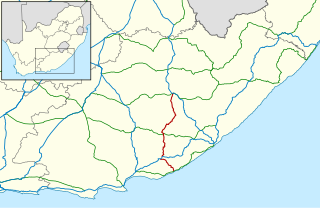
The R63 is a tarred provincial route in South Africa that connects Calvinia with Komga via Carnarvon, Victoria West, Graaff-Reinet, Somerset East and King William's Town. It is cosigned with the N10 between Eastpoort and Cookhouse for 24 kilometres.
The R67 is a provincial route in Eastern Cape, South Africa that connects Port Alfred with Komani via Grahamstown.

The R75 is a provincial route in Eastern Cape, South Africa that connects Graaff-Reinet with Gqeberha via Despatch, Kariega and Jansenville.

The R102 is a Regional Route in South Africa. It is the route designation for all old sections of the N2, thus it is a discontinuous road that resumes in areas where a new N2 has been constructed.

The R310 is a Regional Route in South Africa that connects Muizenberg to the south-west with the R45 between Paarl and Franschhoek to the north-east, via Stellenbosch and Hellshoogte Pass. The section between Muizenberg and Stellenbosch is called Baden Powell Drive.
The R316 is a regional route in the Western Cape province of South Africa that connects Caledon to the northwest with Arniston to the southeast via Bredasdorp and Napier. It runs for 96 kilometres (60 mi). It maintains a south-easterly direction for most of its course.
The R323 is a Regional Route in South Africa that connects Riversdale in the south with Laingsburg in the north.
The R324 is a Regional Route in South Africa that connects Barrydale to the north with Port Beaufort and Witsand to the south.
The R346 is a Regional Route in Eastern Cape, South Africa that connects Kidd's Beach with Stutterheim via King William’s Town.

The N2 is a national route in South Africa that runs from Cape Town through George, Gqeberha, East London, Mthatha, Port Shepstone and Durban to Ermelo. It is the main highway along the Indian Ocean coast of the country. Its current length of 2,255 kilometres (1,401 mi) makes it the longest numbered route in South Africa.
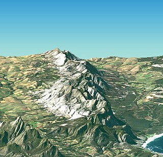
The Kleinrivier Mountains are a mountain range in the Cape Fold Belt of the Western Cape province of South Africa. Kleinrivier means "Small River" in Afrikaans and is named after the river in the area that mouths out near Hermanus where the range begins in the west, then continues eastward to north-east of Stanford and terminates at Akkedisberg Pass. The highest mountain in the range is Maanskynkop (964m) and dominates the entire Walker Bay coastline. The mountains experience a very mild Mediterranean climate, moderated by cool, moist winds blowing off the South Atlantic Ocean. Although no peaks exceed 1000m, the range is still quite imposing, as it rises very steeply from sea level.

The N6 is a national route in South Africa that connects East London with Bloemfontein, via Komani and Maletswai. It runs roughly from north to south, connecting the N1 with the N2.

The N9 is a national route in South Africa that connects George with the N1 at Colesberg, via Graaff-Reinet and Middelburg.
Akkedisberg Pass is situated in the Western Cape province of South Africa, on the Regional road R326 between Riviersonderend and Stanford.
Riviersonderend is a village in the Overberg region of the Western Cape, South Africa, about 140 kilometres (87 mi) east of Cape Town. It is located on a loop of the Sonderend River, from which it takes its name. In the census of 2011 it was recorded as having a population of 5,245. The N2 national road passes through Riviersonderend, forming its main street; it is 161 kilometres (100 mi) by road from central Cape Town.

The M9 is a long metropolitan route in the City of Cape Town, South Africa. It connects Sir Lowry's Pass Village with Wynberg via Somerset West, Firgrove, Macassar, Khayelitsha and Nyanga.

