
The Karoo is a semi-desert natural region of South Africa. No exact definition of what constitutes the Karoo is available, so its extent is also not precisely defined. The Karoo is partly defined by its topography, geology and climate, and above all, its low rainfall, arid air, cloudless skies, and extremes of heat and cold. The Karoo also hosted a well-preserved ecosystem hundreds of million years ago which is now represented by many fossils.
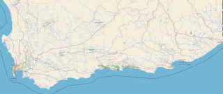
The Garden Route is a 300-kilometre (190 mi) stretch of the south-eastern coast of South Africa which extends from Witsand in the Western Cape to the border of Tsitsikamma Storms River in the Eastern Cape. The name comes from the verdant and ecologically diverse vegetation encountered here and the numerous estuaries and lakes dotted along the coast. It includes towns such as Witsand, Heidelberg, Riversdale, Stilbaai, Albertinia, Gouritsmond, Knysna, Plettenberg Bay, Mossel Bay, Oudtshoorn, Great Brak River, Little Brak River, Wilderness, Sedgefield and Nature's Valley; with George, the Garden Route's largest city and main administrative centre.

Oudtshoorn Municipality is a local municipality within the Garden Route District Municipality, in the Western Cape province of South Africa. As of 2022, the population was 138,257.

Oudtshoorn is a town in the Western Cape province of South Africa, located between the Swartberg mountains to the north and the Outeniqua Mountains to the south. Dubbed the "ostrich capital of the world", Oudtshoorn is known for its ostrich-feather booms, during 1865–1870 and 1900–1914. With approximately 60,000 inhabitants, it is the largest town in the Klein Karoo region. The town's economy is primarily reliant on the ostrich farming and tourism industries. Oudtshoorn is home to the world's largest ostrich population, with a number of specialised ostrich breeding farms, such as the Safari Show Farm and the Highgate Ostrich Show Farm, as stated by Pierre D. Toit.

The Swartberg mountains are a mountain range in the Western Cape province of South Africa. It is composed of two main mountain chains running roughly east–west along the northern edge of the semi-arid Little Karoo. To the north of the range lies the other large semi-arid area in South Africa, the Great Karoo. Most of the Swartberg Mountains are above 2000 m high, making them the tallest mountains in the Western Cape. It is also one of the longest, spanning some 230 km from south of Laingsburg in the west to between Willowmore and Uniondale in the east. Geologically, these mountains are part of the Cape Fold Belt.

The R44 is a provincial route in Western Cape, South Africa that connects Piketberg with Kleinmond via Wellington, Stellenbosch, Somerset West and Strand. The coastal section between Kleinmond and Gordon's Bay is a very scenic ocean drive. The section between Gordon's Bay and Stellenbosch via Strand and Somerset West is a dual carriageway. The R44 is co-signed with the R46 between Gouda and Hermon in the Berg River valley.

The R102 is a Regional Route in South Africa. It is the route designation for all old sections of the N2, thus it is a discontinuous road that resumes in areas where a new N2 has been constructed.
The R327 is a Regional Route in South Africa. Its a regional route in the Western Cape and connects Mossel Bay to Ladismith and part of the northern route is a gravel road.

The R339 is a Regional Route in South Africa that connects Knysna with Uniondale via Avontuur. It is primarily a gravel road and crosses the Langkloof Mountains at Prince Alfred's pass.

The N2 is a national route in South Africa that runs from Cape Town through George, Gqeberha, East London, Mthatha, Port Shepstone and Durban to Ermelo. It is the main highway along the Indian Ocean coast of the country. Its current length of 2,255 kilometres (1,401 mi) makes it the longest numbered route in South Africa.
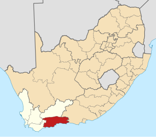
The Garden Route District Municipality, formerly known as the Eden District Municipality, is a district municipality located in the Western Cape province of South Africa. Its municipality code is DC4.

The N12 is a national route in South Africa which runs from George through Beaufort West, Kimberley, Klerksdorp and Johannesburg to eMalahleni.

The N9 is a national route in South Africa that connects George with the N1 at Colesberg, via Graaff-Reinet and Middelburg.

The R62 is a provincial route in South Africa that connects Ashton with Humansdorp. The R62 runs through the Little Karoo and the Langkloof, passing through Montagu, Ladismith, Calitzdorp, Oudtshoorn, and Joubertina.

The Swartberg Pass on the R328 runs over the Swartberg mountain range which runs roughly east–west along the northern edge of the semi-arid area called the Little Karoo in the Western Cape province of South Africa. It's the only road access to Gamkaskloof.
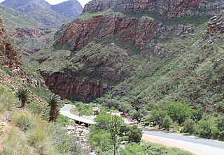
Meiringspoort is a South African mountain pass on the N12 national road, where it crosses the Swartberg mountain range.
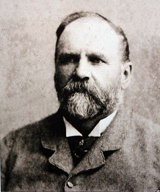
Thomas Charles John Bain was a South African road engineer. As a prolific road building pioneer, Bain was responsible for the planning and construction of more than 900 km of roads and mountain passes, many of them still in use today, over a career spanning from 1848 until 1888. These passes through the mountain ranges between the thin coastal plain and the interior of the former Cape Colony in South Africa, played a major role in opening up the vast hinterland of South Africa.

The Attakwaskloof Pass is a mountain pass situated in the Western Cape province of South Africa on the off-road between Mossel Bay and Oudtshoorn.
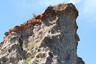
The Enon Formation is a geological formation found in the Eastern and Western Cape provinces in South Africa. It is the lowermost of the four formations found within the Uitenhage Group of the Algoa Basin, its type locality, where it has been measured at a maximum thickness of 480 metres (1,570 ft). Discontinuous outcrops are also found in the Worcester-Pletmos and Oudshoorn-Gamtoos Basins, including isolated occurrences in the Haasvlakte, Jubilee, and Soutpansvlakte Basins near the small town Bredasdorp.

Schoemanshoek is a village on the R328 regional route between Oudtshoorn and the Swartberg in the Western Cape province of South Africa. The village lies on the Grobbelaars River in a valley where tobacco, alfalfa and soft fruit are grown.

