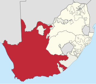
The Province of the Cape of Good Hope, commonly referred to as the Cape Province and colloquially as The Cape, was a province in the Union of South Africa and subsequently the Republic of South Africa. It encompassed the old Cape Colony, as well as Walvis Bay, and had Cape Town as its capital. In 1994, the Cape Province was divided into the new Eastern Cape, Northern Cape and Western Cape provinces, along with part of the North West.

The N1 is a national route in South Africa that runs from Cape Town through Bloemfontein, Johannesburg, Pretoria and Polokwane to Beit Bridge on the border with Zimbabwe. It forms the first section of the famed Cape to Cairo Road.

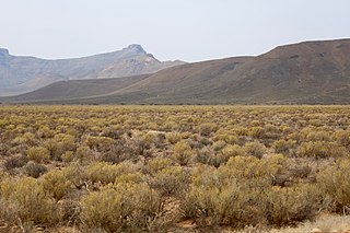
The Karoo is a semi-desert natural region of South Africa. No exact definition of what constitutes the Karoo is available, so its extent is also not precisely defined. The Karoo is partly defined by its topography, geology and climate, and above all, its low rainfall, arid air, cloudless skies, and extremes of heat and cold. The Karoo also hosted a well-preserved ecosystem hundreds of million years ago which is now represented by many fossils.

The R27 is a provincial route in South Africa that consists of two disjoint segments. The first segment, also known as the West Coast Highway, connects Cape Town with Velddrif along the West Coast. The second runs from Vredendal via Vanrhynsdorp, Calvinia, Brandvlei and Kenhardt to Keimoes on the N14 near Upington. The connection between Velddrif and Vredendal has never been built, although it can be driven on various gravel roads.

The R63 is a tarred provincial route in South Africa that connects Calvinia with Komga via Carnarvon, Victoria West, Graaff-Reinet, Somerset East and King William's Town. It is cosigned with the N10 between Eastpoort and Cookhouse for 24 kilometres.
The R355 is a Regional Route in South Africa that connects the R46 near Ceres with Kleinsee via Calvinia and Springbok.
The R356 is a Regional Route in South Africa that connects the R46 near Ceres with Loxton by way of Sutherland and Fraserburg.
The R364 is a Regional Route in South Africa that connects Lamberts Bay to the R27 between Calvinia and Nieuwoudtville via Clanwilliam.

South Africa switched to a closed numbering system effective 16 January 2007. At that time, it became mandatory to dial the full 10-digit telephone number, including the zero in the three-digit area code, for local calls. Area codes within the system are generally organized geographically. All telephone numbers are 9 digits long, except for certain Telkom special services. When dialed from another country, the "0" is omitted and replaced with the appropriate international access code and the country code +27.
The Roggeveld Mountains is a mountain range situated mainly in the Northern Cape province of South Africa. The range forms the western escarpment of the eponymous Roggeveld plateau, and separates it from the lower lying Tankwa Karoo to the west. Its highest peak is Sneeukrans, situated northwest of Sutherland.

Tankwa Karoo National Park is a national park in South Africa. The park lies about 70 km due west of Sutherland near the border of the Northern Cape and Western Cape, in one of the most arid regions of South Africa, with areas receiving less than 100 mm of average annual precipitation, moisture-bearing clouds from the Atlantic Ocean being largely stopped by the Cederberg mountains. Other low areas receive little more, as the Roodewerf station with 180 mm of mean annual rainfall. In the hottest areas of the park, the mean maximum temperature in January is 38.9 °C, and in July the mean minimum temperature ranges from about 5 to 7 °C. Before this Park's proclamation, the only protected area of Succulent Karoo was the 2 square kilometre patch of the Gamkaberg Nature Reserve. Succulent Karoo has, together with the Cape Floral Kingdom, been declared a Biodiversity Hotspot by Conservation International.

Williston is a town in Northern Cape, South Africa. Town 103 km north-east of Calvinia and 140 km south-west of Carnarvon.
Thestor pringlei, the Pringle's skolly, is a species of butterfly in the family Lycaenidae. It is endemic to South Africa, where it is found in the Western Cape in dry Nama Karoo on the Roggeveld escarpment near Sutherland and near Calvinia in the Northern Cape.

Carnarvon is a small town in the Northern Cape Province of South Africa.
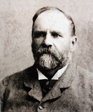
Thomas Charles John Bain was a South African road engineer. As a prolific road building pioneer, Bain was responsible for the planning and construction of more than 900 km of roads and mountain passes, many of them still in use today, over a career spanning from 1848 until 1888. These passes through the mountain ranges between the thin coastal plain and the interior of the former Cape Colony in South Africa, played a major role in opening up the vast hinterland of South Africa.

Calvinia is a regional town in the Northern Cape province of South Africa named after the French religious reformer Jean Calvin. The town falls under the Hantam Local Municipality which forms part of the Namakwa District Municipality. The Calvinia district is part of the Great Karoo region of South Africa. The town is just south of the Hantam mountains on the banks of the Oorlogskloof River.

Matjiesfontein is a settlement in Central Karoo District Municipality in the Western Cape province of South Africa.
Hutchinson is a village and former railway junction in the Northern Cape province of South Africa. It is located 12 kilometres (7 mi) south-east of Victoria West, on the Cape Town–Kimberley railway line. According to the 2011 census it has 367 residents.
The Northern Cape Heritage Resources Authority, previously called Ngwao Boswa jwa Kapa Bokone, and commonly known as 'Boswa', is a provincial heritage resources authority established in 2003 by the MEC for Sport, Arts and Culture in the Northern Cape Province of South Africa, and reconstituted in terms of the Northern Cape Heritage Resources Authority Act, 2013. It is an institution set up under the terms of the National Heritage Resources Act. It is mandated to care for that part of South Africa's national estate that is of provincial and local significance in the Northern Cape.
Pakhuis Pass is a mountain pass on the R364 in the northern Cederberg in South Africa. The pass connects Clanwilliam to Calvinia. A turnoff from the pass heads southeast to the Biedouw Valley and Wupperthal. The pass is 25 km long, reaches an altitude of 905 m at a gradient of 1:9.

