Johan Anthoniszoon "Jan" van Riebeeck was a Dutch navigator, ambassador and colonial administrator of the Dutch East India Company.

Swartland Municipality is a local municipality located in the Western Cape province of South Africa. Malmesbury is the seat of the municipality. As of 2022, it had a population of 148,331. Its municipality code is WC015.

The R27 is a provincial route in South Africa that consists of two disjoint segments. The first segment, also known as the West Coast Highway, connects Cape Town with Velddrif along the West Coast. The second runs from Vredendal via Vanrhynsdorp, Calvinia, Brandvlei and Kenhardt to Keimoes on the N14 near Upington. The connection between Velddrif and Vredendal has never been built, although it can be driven on various gravel roads.

The R44 is a provincial route in Western Cape, South Africa that connects Piketberg with Kleinmond via Wellington, Stellenbosch, Somerset West and Strand. The coastal section between Kleinmond and Gordon's Bay is a very scenic ocean drive. The section between Gordon's Bay and Stellenbosch via Strand and Somerset West is a dual carriageway. The R44 is co-signed with the R46 between Gouda and Hermon in the Berg River valley.

The R45 is a provincial route in Western Cape, South Africa that connects Saldanha with Villiersdorp via Vredenburg, Malmesbury and Paarl. The route is mostly a two-lane wide-shouldered highway, however sections within Paarl and between Vredenburg and Saldanha are dual-carriageways. The R45 is co-signed with the N7 for a short segment north of Malmesbury.

The R46 is a provincial route in Western Cape, South Africa that connects Malmesbury with Touws River, via Riebeek-Kasteel, Tulbagh and Ceres. The R46 is co-signed with the R44 between Gouda and Hermon in the Berg River valley.

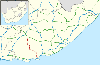
The R75 is a provincial route in Eastern Cape, South Africa that connects Graaff-Reinet with Gqeberha via Despatch, Kariega and Jansenville.
The R307 is a Regional Route in South Africa that connects the R27 north of Melkbosstrand with the R45 south-west of Moorreesburg.

The R310 is a Regional Route in South Africa that connects Muizenberg to the south-west with the R45 between Paarl and Franschhoek to the north-east, via Stellenbosch and Hellshoogte Pass. The section between Muizenberg and Stellenbosch is called Baden Powell Drive.

The R321 is a Regional Route in South Africa that connects Grabouw in the south-west to the R45 between Franschhoek and Villiersdorp in the north-east.
The R399 is a Regional Route in South Africa that connects Vredenburg with the N7 between Piketberg and De Hoek.

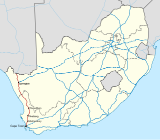
The N7 is a national route in South Africa that runs from Cape Town northwards through the West Coast and Namaqualand regions to the Namibian border at Vioolsdrif. It is known as the Cape Namibia Road. After crossing the border, it changes designation to B1 and runs north through Windhoek and the north of Namibia.

The Swartland is a region of Western Cape Province that begins some 50 kilometres (31 mi) north of Cape Town and consists of the area between the towns of Malmesbury in the south, Darling in the west, Piketberg in the north, Moorreesburg in the middle and the Riebeek West and Riebeek Kasteel in the east. Jan van Riebeeck called this softly undulating country between the mountain ranges "Het Zwarte Land" because of the endemic Renosterbos. After the rains, mainly in winter, the Renosterbos takes on a dark appearance when viewed from the distance in large numbers. This is due to the fine leaf-hairs adhering to the leaves when wet. The wide fertile plain is the bread basket of Cape Town with its wheat fields reaching up to the foot of the mountains, interrupted by wine, fruit, and vegetable farms. In Moorreesburg can be found only one of two museums in the world that shows the history of wheat farming.

Riebeek-Kasteel is one of the oldest towns in South Africa, situated at 80 km north-east of Cape Town in The Riebeek Valley together with its sister town Riebeek West. They set off in the direction of Paardeberg and on 3 February 1661 they ascended a lonely mountain and came upon the fertile vista of the Riebeek Valley. They named it Riebeek Kasteel, in honor of the Commander.

Riebeek West is a small town situated about 75 km north-east of Cape Town and 5 km north of its twin town Riebeek Kasteel in the Swartland area of the Western Cape, South Africa.

The Royal Hotel in Riebeek Kasteel is the oldest licensed hotel of the Western Cape and was built in 1862. This now fully restored heritage building is one of the few hotels left of that particular colonial era of South Africa. Famous visitors in history were Jan Smuts and Daniel Malan, both from the Riebeek Valley and both prime ministers of South Africa during troubled times. In 2006 southafrica.org placed The Royal as only hotel on the list of "the 50 most fabulous places to visit in SA". According to them it has the longest stoep (veranda) south of the Limpopo.

Bothmanskloof Pass is situated in the Western Cape province of South Africa, on the R46 between Malmesbury and Riebeek Kasteel. It is also sometimes called Bothmaskloof.
The R301 is a regional route in the Western Cape province of South Africa that connects Wemmershoek with Wolseley via Paarl and Wellington.
Leán Coetzer is a South African dancer and choreographer. Her dance career officially began as founder member of the PACT Dance Company in 1988. Since then, Coetzer has performed and choreographed around South Africa, including the creation of several performance art pieces in various exhibitions and festivals. She works as a Voice Movement Therapy Practitioner.
Esterhof is a settlement and housing development in West Coast District Municipality in the Western Cape province of South Africa. Esterhof is located roughly two kilometers to the east of Riebeek-Kasteel, separated by a railway and industrial buildings, and was originally created as part of apartheid initiatives that forcibly displaced Coloured people out of Oukloof in the 1960s.


