Ceres, South Africa

Last updated

Ceres
Ceres town.jpg
Town centre of Ceres with its main street on a winter day
South Africa Western Cape location map.svg
Red pog.svg
Ceres
South Africa adm location map.svg
Red pog.svg
Ceres
Coordinates: 33°22′S19°19′E / 33.367°S 19.317°E / -33.367; 19.317
Country South Africa
Province Western Cape
District Cape Winelands
Municipality Witzenberg
Established1854 [1]
Area
[2]
  Total80.7 km2 (31.2 sq mi)
Elevation
450 m (1,480 ft)
Population
 (2011) [2]
  Total33,224
  Density410/km2 (1,100/sq mi)
Racial makeup (2011)
[2]
   Black African 28.7%
   Coloured 61.4%
   Indian/Asian 0.4%
   White 8.5%
  Other1.0%
First languages (2011)
[2]
   Afrikaans 70.2%
   Xhosa 23.0%
   Sotho 2.9%
   English 2.1%
  Other1.9%
Time zone UTC+2 (SAST)
Postal code (street)
6835
PO box
6835
Area code 023

Ceres is the administrative centre and largest town of the Witzenberg Local Municipality in the Western Cape Province of South Africa. Ceres serves as a regional centre for the surrounding towns of Wolseley, Tulbagh, Op-die-Berg and Prince Alfred Hamlet. It is situated in the Warmbokkeveld (Afrikaans: "warm antelope field") Valley about 170 km north-east of Cape Town. Ceres is located at the north-eastern entrance to Michell's Pass and was the old route north between Cape Town and Johannesburg, which was later replaced by the N1 highway, which traverses the Breede River Valley to the south.

Contents

Named after the Roman goddess of agriculture, Ceres, a name which is fitting as the valley in which the town is situated is extremely fertile and is a major producer of South Africa's deciduous fruit.

Geography and climate

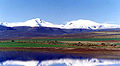
Ceres experiences a typical Mediterranean climate tempered by its altitude. The town experiences warmer temperatures in summer, due to its inland location with infrequent rainfall, however winters are cool to quite cold and wet, with frequent snowfalls on the surrounding higher-lying ground, rarely falling on the valley floor itself. Total annual precipitation averages 1088 mm, with average temperatures ranging from a February maximum of 29,9 °C to a July minimum of 2,4 °C.

The Warmbokkeveld is climatically warmer than the surrounding highlands, which is known as the Kouebokkeveld ("cold antelope field"), with the latter often experiencing snowfalls in winter.

Ceres is well known for fruit juices exported worldwide bearing the town's name. It is also famous locally for winter snow and cherries: Cape Town residents flock to the town during winter to ski or simply play in the powder something of a rarity for the otherwise mild climate they are used to whilst in summer, people come to pick cherries at the "Klondyke" farm.

South Africa is one of the most stable parts of the world in seismic terms but on 29 September 1969 [3] a massive shock shook the district without warning. The epicentre of the quake was on a major local structure called the Worcester fault, which had clearly been geologically active in the distant past but had not moved in over three hundred years of recorded history. Ceres was affected badly. Many old Cape Dutch buildings were damaged [4] and some people died. The quake was strong enough to knock plaster off walls in Cape Town, a hundred miles (160 kilometres) away.

Famous people

Coats of arms

Municipal (1) — The Ceres municipal council assumed a pseudo-heraldic "coat of arms" in 1928. [5] [6] The shield was quartered, and depicted (1) a sheaf of wheat on a red background, (2) a landscape scene showing a bridge across a river, (3) a tree on a sky blue background, and (4) a cornucopia on a green background. The motto was Loci dulcedo nos attinet.

Municipal (2) — The council assumed a proper coat of arms, designed by Ivan Mitford-Barberton and H. Ellis Tomlinson, in 1948. [7] This was in response to a Cape Provincial Administration circular asking municipalities to have their arms checked and, if necessary, re-designed, to make them heraldically correct. The new arms were registered at the Bureau of Heraldry in March 1974. [8]

The arms were : Vert, a fess wavy Argent, thereon a barrulet wavy Azure, over all a pale Argent charged with a representation of the goddess Ceres, vested Vert, holding in her dexter hand a sheaf of wheat and in her sinister a torch enflamed all proper; in chief a mural crown Gules. The motto was the same as before. In layman's terms, the new design was a green shield with a silver/blue/silver wavy stripe across the middle, and a vertical silver stripe depicting a red mural crown and the figure of the Roman goddess Ceres.

See also

Ceres Valley Panorama View.jpg
A panoramic view of the Ceres valley.

Related Research Articles

Polokwane, also known as Pietersburg, is a city and the capital of the Limpopo Province of South Africa. It is South Africa's largest urban centre north of Gauteng. It was one of the host cities of the 2010 FIFA World Cup.

<span class="mw-page-title-main">Pietermaritzburg</span> Capital city of KwaZulu-Natal, South Africa

Pietermaritzburg is the capital and second-largest city in the province of KwaZulu-Natal, South Africa. It was founded in 1838 and is currently governed by the Msunduzi Local Municipality. Its Zulu name umGungundlovu is the name used for the Umgungundlovu District Municipality. Pietermaritzburg is popularly called Maritzburg in Afrikaans, English and Zulu alike, and often informally abbreviated to PMB. It is a regionally important industrial hub, producing aluminium, timber and dairy products, as well as the main economic hub of Umgungundlovu District Municipality. The public sector is a major employer in the city due to local, district and provincial government offices located here.

<span class="mw-page-title-main">Coat of arms of Toronto</span> Official coat of arms of the City of Toronto

The coat of arms of Toronto is a heraldic symbol used to represent the city Toronto. Designed by Robert Watt, the Chief Herald of Canada at the time, for the City of Toronto after its amalgamation in 1998. The arms were granted by the Canadian Heraldic Authority on 11 January 1999.

<span class="mw-page-title-main">Uitenhage</span> Place in Eastern Cape, South Africa

Uitenhage, officially renamed Kariega, is a South African town in the Eastern Cape Province. It is well known for the Volkswagen factory located there, which is the biggest car factory on the African continent. Along with the city of Port Elizabeth and the small town of Despatch, it forms the Nelson Mandela Bay Metropolitan Municipality.

<span class="mw-page-title-main">Graaff-Reinet</span> Place in Eastern Cape, South Africa

Graaff-Reinet is a town in the Eastern Cape Province of South Africa. It is the oldest town in the province. It is also the sixth-oldest town in South Africa, after Cape Town, Stellenbosch, Simon's Town, Paarl and Swellendam. The town was the centre of a short-lived republic in the late 18th century. The town was a starting point for Great Trek groups led by Gerrit Maritz and Piet Retief and furnished large numbers of the Voortrekkers in 1835–1842.

<span class="mw-page-title-main">Bethlehem, South Africa</span> Place in Free State, South Africa

Bethlehem is a city in the eastern Free State province of South Africa that is situated on the Liebenbergs river along a fertile valley just north of the Rooiberg Mountains on the N5 road. It is the fastest growing city in the Free state province, with its target of being the third largest city after Bloemfontein and Welkom.

<span class="mw-page-title-main">Witzenberg Local Municipality</span> Local municipality in Western Cape, South Africa

Witzenberg Municipality is a local municipality located within the Cape Winelands District Municipality, in the Western Cape province of South Africa. As of 2011 it had a population of 115,946.

<span class="mw-page-title-main">Strand, Western Cape</span> Seaside town in the Western Cape, South Africa

Strand is a seaside resort town in the Western Cape, South Africa. It forms part of the Helderberg region of the City of Cape Town Metropolitan Municipality, situated on the north-eastern edge of False Bay and near the foot of the Helderberg Mountains. Its geographical position is between Somerset West and Gordon's Bay, and is about 50 km southeast of Cape Town City Bowl. Strand has a population of approximately 50,000. Strand's main attraction is the beach; 5 km of white sandy beach off False Bay.

<span class="mw-page-title-main">Simon's Town</span> Seaside town in the Western Cape, South Africa

Simon's Town, sometimes spelled Simonstown, is a town in the Western Cape, South Africa and is home to Naval Base Simon's Town, the South African Navy's largest base. It is located on the shores of False Bay, on the eastern side of the Cape Peninsula. For more than two centuries it has been a naval base and harbour. The town is named after Simon van der Stel, an early governor of the Cape Colony.

<span class="mw-page-title-main">Worcester, South Africa</span> Town in Western Cape, South Africa

Worcester is a town in the Western Cape, South Africa. It is the third-largest city in the western cape province of South Africa. It is located 120 kilometres (75 mi) north-east of Cape Town on the N1 highway north to Johannesburg.

<span class="mw-page-title-main">Coat of arms of Edmonton</span>

The coat of arms of Edmonton was granted on 28 October 1994.

<span class="mw-page-title-main">Cradock, South Africa</span> Place in Eastern Cape, South Africa

Cradock is a town in the Eastern Cape Province of South Africa, in the upper valley of the Great Fish River, 250 kilometres (160 mi) by road northeast of Port Elizabeth. The town is the administrative seat of the Inxuba Yethemba Local Municipality in the Chris Hani District of the Eastern Cape.

<span class="mw-page-title-main">De Aar</span> Place in Northern Cape, South Africa

De Aar is a town in the Northern Cape province of South Africa. It has a population of around 42,000 inhabitants.

<span class="mw-page-title-main">Clanwilliam, South Africa</span> Place in Western Cape, South Africa

Clanwilliam is a town in the Olifants River valley in the Western Cape, South Africa, about 200 kilometres (120 mi) north of Cape Town. It is located in, and the seat of, the Cederberg Local Municipality. As of 2011 Clanwilliam had a population of 7,674.

<span class="mw-page-title-main">Gordon's Bay</span> Harbour town in the Western Cape, South Africa

Gordon's Bay is a harbour town in the Western Cape province of South Africa. It is included in the City of Cape Town metropolitan municipality as a suburb of the Helderberg region. It is situated on the shores of Gordon's Bay in the northeastern corner of False Bay about 58 km from Cape Town to the south of the N2 national road and is named after Robert Jacob Gordon (1743–1795), the Dutch explorer of Scottish descent.

<span class="mw-page-title-main">Wellington, South Africa</span> Place in Western Cape, South Africa

Wellington is a town in the Western Cape Winelands, a 45-minute drive from Cape Town, in South Africa with a population of approximately 62,000. Wellington's economy is centered on agriculture such as wine, table grapes, deciduous fruit, and a brandy industry. The town is located 75 km north-east of Cape Town, reached by the N1 motorway and R44. Due to the growth of the Flakkaland and Mbekweni township south of the town, it now forms a de facto urban unit with Paarl, just 10 km to the south. Wellington now officially falls under the Drakenstein Local Municipality, which also covers Saron and Paarl.

<span class="mw-page-title-main">Malmesbury, South Africa</span> Place in Western Cape, South Africa

Malmesbury is a town of approximately 36,000 inhabitants in the Western Cape province of South Africa, about 65 km north of Cape Town.

<span class="mw-page-title-main">Tulbagh</span> Place in Western Cape, South Africa

Tulbagh, previously named Roodezand, later named after Dutch Cape Colony Governor Ryk Tulbagh, is a town located in the "Land van Waveren" mountain basin, in the Winelands of the Western Cape, South Africa. The basin is fringed on three sides by mountains, and is drained by the Klein Berg River and its tributaries. The nearest towns are Ons Rust and Gouda beyond the Nuwekloof Pass, Wolseley some 15 kilometres (9.3 mi) to the south inside the basin, and Ceres and Prince Alfred Hamlet beyond Michell's Pass in the Warm Bokkeveld.

<span class="mw-page-title-main">Pall (heraldry)</span>

A pall in heraldry and vexillology is a Y-shaped charge, normally having its arms in the three corners of the shield. An example of a pall placed horizontally (fesswise) is the green portion of the South African national flag.

<span class="mw-page-title-main">Coat of arms of Penang</span> Heraldic emblem representing the Malaysian state of Penang

The Coat of arms of Penang is largely based on the coat of arms of Penang first granted to the Settlement of Penang, then in the Federation of Malaya, by a Royal Warrant of King George VI dated 11 September 1949.

References

  1. Robson, Linda Gillian (2011). "Annexure A" (PDF). The Royal Engineers and settlement planning in the Cape Colony 1806–1872: Approach, methodology and impact (PhD thesis). University of Pretoria. pp. xlv–lii. hdl:2263/26503.
  2. 1 2 3 4 Sum of the Main Places Bella Vista, Ceres and eNduli from Census 2011.
  3. "1969 Tulbagh and Ceres Earthquake". Archived from the original on 27 April 2012. Retrieved 25 March 2013.
  4. "Ceres Transport Riders Museum". www.ceresmuseum.co.za.
  5. Western Cape Archives : Ceres Municipal Minutes (2 March 1928).
  6. The arms were depicted on a cigarette card issued in 1931.
  7. Western Cape Archives : Ceres Municipal Minutes (28 June 1948).
  8. "National Archives of South Africa (NASA) Database Selection". www.national.archsrch.gov.za.