Paarl is a town with 285,574 inhabitants in the Western Cape province of South Africa. It is the largest town in the Cape Winelands. Due to the growth of the Mbekweni township, it is now a de facto urban unit with Wellington. It is situated about 60 kilometres (37 mi) northeast of Cape Town in the Western Cape Province and is known for its scenic environment and viticulture and fruit-growing heritage.

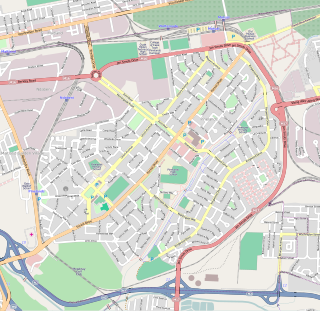
Stellenbosch is a town in the Western Cape province of South Africa, situated about 50 kilometres east of Cape Town, along the banks of the Eerste River at the foot of the Stellenbosch Mountain. The town became known as the City of Oaks or Eikestad in Afrikaans and Dutch due to the large number of oak trees that were planted by its founder, Simon van der Stel, to grace the streets and homesteads.
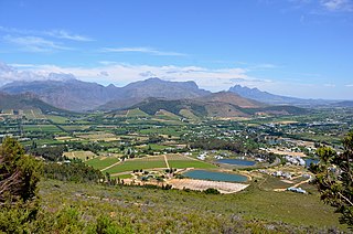
Franschhoek is a small town in the Western Cape Province and one of the oldest towns in South Africa. It was formerly known as Oliphants hoek. It is situated about 75 kilometres (47 mi) from Cape Town, a 45-minute drive away. The whole area, including townships such as Groendal and suburbs such as Wemmershoek, has a population of slightly over 20,000 people while the town proper, known as Hugenote, has a population of around 1,000. Since 2000, it has been incorporated into Stellenbosch Municipality. In 2022, Franschhoek was mentioned in Time magazine as one of the top 50 places in the world to visit.
Jacobsdal is a small farming town in the Free State province of South Africa with various crops under irrigation, such as grapes, potatoes, lucerne, and groundnuts. The town was laid out in 1859 by Christoffel Jacobs on his farm Kalkfontein, and its last recorded population was 3,504.
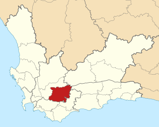
Langeberg Municipality, known before 28 August 2009 as Breede River/Winelands Municipality, is a local municipality located within the Cape Winelands District Municipality, in the Western Cape province of South Africa. As of 2011, it had a population of 97,724. Its municipality code is WC026.

São Filipe is a city on the west coast of the island of Fogo, Cape Verde. It is the capital of the island, and the seat of the São Filipe Municipality. The island's airport, São Filipe Airport, is located on the southeastern edge of the town and the island's port is 4 km north of the center at Vale de Cavaleiros. The town's elevation is 20 meters.
Pinelands is an affluent garden city suburb located on the northern edge of the southern suburbs of Cape Town, South Africa, neighbouring the suburb of Thornton, and is known for its large thatched houses and green spaces. The suburb is primarily residential and is often praised for its peacefulness and abundance of trees. Pinelands is one of the few areas in Cape Town in which sale of alcohol to the public is prohibited, but some clubs have private liquor licenses. It is a popular place for senior citizens to retire to. While there are several retirement homes in the suburb, younger people are increasingly moving in.

Tokai, a large residential suburb of Cape Town, South Africa, is situated on the foothills of the Constantiaberg, and is bordered by Steenberg and Kirstenhof to the south, Bergvliet to the east, Constantia to the north and the SAFCOL pine tree plantations against the mountain to the west.

Somerset West is a town in the Western Cape, South Africa. Organisationally and administratively it is included in the City of Cape Town metropolitan municipality Eastern Suburbs zone . The vehicle registration code for Somerset West is CFM and the post code is 7130 for street addresses, and 7129 for post office boxes.
South African wine has a history dating back to 1659 with the first bottle being produced in Cape Town by its founder and governor Jan van Riebeeck. Access to international markets led to new investment in the South African wine market. Production is concentrated around Cape Town and almost exclusively located within the Western Cape province, with major vineyard and production centres at Constantia, Paarl, Stellenbosch and Worcester.

Constantia is an affluent suburb of Cape Town, South Africa, situated about 15 kilometres south of the centre of Cape Town. It is considered to be one of the most prestigious suburbs in South Africa. The Constantia Valley lies to the east of and at the foot of the Constantiaberg mountain. Constantia Nek is a low pass linking to Hout Bay in the west.

Groot Constantia is the oldest wine estate in South Africa and provincial heritage site in the suburb of Constantia in Cape Town, South Africa.

Cape Dutch architecture is an architectural style found mostly in the Western Cape of South Africa, but modern examples of the style have also been exported as far afield as Western Australia and New Zealand, typically on wine estates. The style was prominent in the early days of the Cape Colony, and the name derives from the initial settlers of the Cape being primarily Dutch. The style has roots in medieval Netherlands, Germany, France and Indonesia.

Durbanville, previously called Pampoenkraal, is a town in the Western Cape province of South Africa, part of the greater Cape Town metropolitan area. It is a semi-rural residential suburb on the north-eastern outskirts of the metropolis surrounded by farms producing wine and wheat.

Grabouw is a town located in the Western Cape province of South Africa. Grabouw is located some 65 km south-east of Cape Town, over Sir Lowry's Pass from Somerset West, along the N2 highway. The town is the commercial centre for the vast Elgin Valley, the largest single export fruit-producing area in Southern Africa, which extends between the Hottentots-Holland, Kogelberg, Groenland, and Houwhoek Mountains. The town's population has grown rapidly, with 44 593 people in 2019 from 21 593 as listed by the 2001 census.

The South African Railways Class 15B 4-8-2 of 1918 was a steam locomotive.
Gert Johannes Gerwel known mononymously as Jakes, was a South African academic and anti-apartheid activist. He served as Director-General of the Presidency when Nelson Mandela was in office. In 1999 Gerwel was instrumental in brokering the deal under which Lockerbie bombing suspects were extradited to Scotland. Following Mandela's presidency, Gerwel chaired the Nelson Mandela Foundation and the Mandela Rhodes Foundation, and also took up a number of academic and business positions until his death in November 2012.

Stormsvlei is a town on the southern bank of the Riviersonderend, some 17 km south of Bonnievale and 50 km north of Bredasdorp. Of Afrikaans origin, the name means 'storm marsh'.
A number of units of measurement were used in South Africa to measure quantities like length, mass, capacity, etc. The Imperial system of measurements was made standard in 1922 and the metric system was adopted in 1961.