Knysna is a town with 76,150 inhabitants in the Western Cape province of South Africa. It is one of the destinations on the loosely defined Garden Route tourist route. It is situated 60 kilometres east of the city of George on the N2 highway, and 33 kilometres west of the Plettenberg Bay on the same road.

Drakenstein Municipality is a local municipality located within the Cape Winelands District Municipality, in the Western Cape province of South Africa. As of 2011, it had a population of 251,262. Its municipality code is WC023.

Bergrivier Municipality is a local municipality in the Western Cape province of South Africa. It governs the towns of Piketberg, Velddrif and Porterville, as well as the surrounding villages and rural areas. As of 2011, it had a population of 61,897. It is located within the West Coast District Municipality and its municipality code is WC013.

The R44 is a provincial route in Western Cape, South Africa that connects Piketberg with Kleinmond via Wellington, Stellenbosch, Somerset West and Strand. The coastal section between Kleinmond and Gordon's Bay is a very scenic ocean drive. The section between Gordon's Bay and Stellenbosch via Strand and Somerset West is a dual carriageway. The R44 is co-signed with the R46 between Gouda and Hermon in the Berg River valley.

Noordhoek is a seaside town in the Western Cape, South Africa, located below Chapman's Peak on the west coast of the Cape Peninsula and is approximately 35 kilometres (22 mi) to the south of Cape Town. The name "Noordhoek" was taken from Dutch and literally means "north corner". It was given this name in 1743 as being the northern corner of the Slangkop farm. The first permanent resident of European origin is Jaco Malan who built his house there. In 1857, the region was divided into six plots, most of which were bought by a single family, that of the de Villiers. Noordhoek nevertheless remains a predominantly rural area where farmers grow vegetables to supply ships calling at Simon's Town. It is best known for its shoreline and its long, wide, sandy beach, which stretches south to the neighbouring village of Kommetjie. Near the southern end of this beach is the wreck of the steamship "Kakapo", which ran aground in 1900, when the captain mistook Chapman's Peak for the Cape of Good Hope and put the helm over to port.

Concor Holdings (Proprietary) Limited. is a South African construction and mining services company. It is active throughout Southern Africa, involved in civil engineering, buildings, roads and mining projects. Concor returned as an independent brand in late 2016.

Tulbagh, previously named Roodezand, later named after Dutch Cape Colony Governor Ryk Tulbagh, is a town located in the "Land van Waveren" mountain basin, in the Winelands of the Western Cape, South Africa. The basin is fringed on three sides by mountains, and is drained by the Klein Berg River and its tributaries. The nearest towns are Ons Rust and Gouda beyond the Nuwekloof Pass, Wolseley some 15 kilometres (9.3 mi) to the south inside the basin, and Ceres and Prince Alfred Hamlet beyond Michell's Pass in the Warm Bokkeveld.

Grabouw is a town located in the Western Cape province of South Africa. Grabouw is located some 65 km south-east of Cape Town, over Sir Lowry's Pass from Somerset West, along the N2 highway. The town is the commercial centre for the vast Elgin Valley, the largest single export fruit-producing area in Southern Africa, which extends between the Hottentots-Holland, Kogelberg, Groenland, and Houwhoek Mountains. The town's population has grown rapidly, with 44 593 people in 2019 from 21 593 as listed by the 2001 census.
Yzerfontein, or Ysterfontein, is a small harbour town with about 1200 inhabitants on the west coast of South Africa about 90 km north of Cape Town. The name in Afrikaans means "Iron Fountain".The town started out when the farm 'Yzerfontein' was bought by the Katz-family in the 1930s. Then they started dividing the farm into plots. The main sources of income are tourism, mining and fishing.

Cookhouse is a small village located in Eastern Cape province, South Africa, some 170 kilometres (110 mi) north of Port Elizabeth and 24 kilometres (15 mi) east of Somerset East, on the west bank of the Great Fish River.
Porterville is a town in the Western Cape province of South Africa.
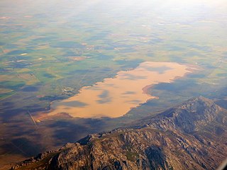
Voëlvlei Dam is a dam located in the Western Cape, South Africa near the town of Gouda. The earth-fill wall is 2,910 metres (9,550 ft) long and 10 metres (33 ft) high. The reservoir covers an area of 1,524 hectares and has a capacity of 168,000 megalitres, making it the second-largest reservoir in the Western Cape Water Supply System. Water from the reservoir is supplied to water treatment works of the City of Cape Town and the West Coast District Municipality, and can also be released into the Berg River for agricultural purposes or to fill the Misverstand Dam.
Swartland Alluvium Fynbos is a critically endangered vegetation type that occurs on the high plains and mountains in the far south-west of the Western Cape, South Africa.
Sere Wind Farm is a windfarm in the Western Cape province of South Africa that is one of the largest windfarms in Southern Africa with a production capacity of 100 MW. The project is estimated to have cost R2.689 billion. Eskom stated that the plant was fully commissioned on 31 March 2015.

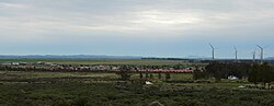
Gouda Wind Farm is a wind farm just outside the town of Gouda in the Western Cape province of South Africa that at 138MW is one of the largest wind-farms in Southern Africa. The project cost R2.7 billion and was brought online in early September 2015. At the time of its completion it was the largest wind-farm in the Western Cape. It is capable of powering 200 000 households per year or 400 gigawatt hours of electricity. It is estimated that power generated from Gouda Wind Farm will avoid the emission of 406 million metric tons of CO2 per year of equivalent power produced from a coal fired power plant. It is owned in partnership between the South African renewable energy and engineering firm Aveng and Spanish renewable energy company Acciona Energia.

Honey 3: Dare to Dance is a 2016 American dance film directed by Bille Woodruff and starring Cassie Ventura and Kenny Wormald. It is the third installment in the Honey film series. The film was released on Netflix and DVD and Blu-ray on September 6, 2016. Filming for Honey 3 took place in Cape Town, South Africa.
The 1969 Tulbagh earthquake occurred at 20:03:33 UTC on 29 September. It had a magnitude of 6.3 and a maximum felt intensity of VIII (Severe) on the Modified Mercalli intensity scale. It caused widespread damage in the towns of Ceres, Tulbagh and Wolseley and led to 12 deaths. The earthquake was a result of strike-slip faulting along a NW-SE trending near vertical fault plane, as shown by the focal mechanism and the distribution of aftershocks.

The Roggeveld Wind Power Station is an operational 147 MW (197,000 hp) wind power plant in South Africa. The power station, which began commercial operations in March 2022, was developed and is owned by Building Energy. The energy generated at this wind farm is sold to the South African national electricity utility company Eskom, under a 20-year power purchase agreement (PPA).