R38 (South Africa)

Last updated

SA road R38.svg
Provincial route R38
Map of the R38 (South Africa).svg
Route information
Maintained by MDPWRT and SANRAL
Length300 km (190 mi)
Major junctions
Southwest endSA road R39.svg R39 near Standerton
Major intersectionsSA road N17 jct.svgSA road R35.svg N17  / R35 in Bethal
SA road N11 jct.svg N11 in Hendrina
SA road R33.svgSA road R36.svg R33  / R36 in Carolina
SA road R40.svg R40 in Barberton
Northeast endSA road N4 jct.svg N4 in Kaapmuiden
Location
Country South Africa
Major cities Standerton, Bethal, Hendrina, Carolina, Badplaas, Barberton
Highway system
SA road R37.svg R37 SA road R39.svg R39

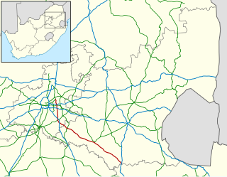
The R38 is a provincial route in South Africa that connects Standerton with Kaapmuiden via Bethal, Carolina and Barberton. It is a main route through the province of Mpumalanga. [1]

Contents

Route

The R38 starts at a junction with the R39 road 16 kilometres north-east of Standerton, just north-east of the Grootdraai Dam. [2] :22 It begins by heading north-north-east for 44 kilometres to the town of Bethal. [2] :22 It bypasses the Emziinoni Township and enters Bethal as Anderson Street. At the Simon Street junction, the R38 becomes Simon Street eastwards.

At the junction just after Bethal Police Station, the R38 meets the N17 national route and the R35 route and all 3 routes join to become the main road through Bethal Central northwards (Moses Kotane Street). At the sixth junction afterwards, just after crossing the Blesbokspruit, the R35 and R38 leave Moses Kotane Street (which remains designated as the N17) and become the road eastwards. At the second junction afterwards, the R38 splits from the R35 to become its own road eastwards (Station Road). At the Holland Street junction in Bethal East, the R38 becomes the road northwards.

From Bethal East, the R38 goes north-east for 38 kilometres, crossing the Olifants River, to the town of Hendrina. [2] :30 It passes through Hendrina eastwards as Beukes Street and meets the N11 national route (Church Street) in the town centre. The R38 leaves the town in an easterly direction and goes for 38 kilometres, crossing the Klein Olifants River and the Vaalwaterspruit, to reach a T-junction with the R36 road just west of the Boesmanspruitdam. The R38 joins the R36 and they form one road into the Carolina town centre, crossing the Boesmanspruit. [2] :30

At the Voortrekker Street junction in Carolina town centre, the R38/R36 meet the R33 route & the R38 leaves the R36 to become co-signed with the R33 on Voortrekker Street eastwards. Just south of the Carolina Railway Station, the R33 splits and becomes the road southwards, leaving the R38 as the road eastwards.

From Carolina, the R38 heads east-north-east as the Bothasnek Pass for 50 kilometres to Badplaas, where it is joined by the R541 route and crosses the Seekoeispruit. [2] :30 After 5 kilometres, the R541 becomes its own road northwards while the R38 continues east-north-east for another 56 kilometres as the Nelshoogte Pass, crossing the Komati River south of the Vygeboom Dam, to reach a T-junction with the R40 road south of Barberton Airport. [2] :30 The R38 joins the R40 and they are one road south-east for 7 kilometres (Dikbas Avenue) up to a junction with Sheba Road north of the town centre of Barberton. [2] :31 At this junction, the R40 remains on Dikbas Avenue while the R38 becomes the road northwards (Sheba Road).

The R38 goes north-east for 49 kilometres, bypasses the Mountainlands Nature Reserve, following the Kaap River, up to Kaapmuiden (south of Matsulu), where it ends at a T-junction with the N4 national route (Maputo Corridor). [2] :31

Related Research Articles

Bethal is a farming town in Mpumalanga, South Africa. The farms in the region produce maize, sunflower seeds, sorghum, rye and potatoes. The town lies 155 km (96 mi) east of Johannesburg on the N17 national route.
<span class="mw-page-title-main">R23 (South Africa)</span>

The R23 is a provincial route in South Africa that links Benoni with Volksrust via Brakpan, Heidelberg and Standerton.

<span class="mw-page-title-main">R30 (South Africa)</span> Road in South Africa

The R30 is a provincial route in South Africa that connects Bloemfontein with Rustenburg via Brandfort, Welkom, Bothaville, Klerksdorp and Ventersdorp. The southern part of the route is tolled, as the R30 forms the first section of the ZR Mahabane Toll Route, with the Brandfort Toll Plaza found 10 kilometres north of its Southern junction with the N1 National Route. The tolled portion ends at the junction with the R730.

<span class="mw-page-title-main">R33 (South Africa)</span> Road in South Africa

The R33 is a provincial route in South Africa that connects Pietermaritzburg with Lephalale via Greytown, Paulpietersburg, Carolina, Belfast and Vaalwater. It is a very long road, passing through 3 provinces.

<span class="mw-page-title-main">R34 (South Africa)</span> Road in South Africa

The R34 is a long provincial route in South Africa that connects Vryburg with Richards Bay via Kroonstad and Newcastle. It passes through three provinces, North West, the Free State and KwaZulu-Natal.

<span class="mw-page-title-main">R35 (South Africa)</span>

The R35 is a provincial route in Mpumalanga, South Africa that connects Amersfoort with Middelburg via Morgenzon and Bethal. The R35 used to connect with the N3 near Ladysmith, but the portion of the road from Amersfoort onwards is now part of the N11.

<span class="mw-page-title-main">R36 (South Africa)</span>

The R36 is a provincial route in South Africa that connects the N1 at Bandelierkop with Ermelo, via Tzaneen and Lydenburg. It is co-signed with the N4 for 8 kilometres between Machadodorp and Patattanek, with a tollgate on this section. It used to extend further south past Ermelo to Amersfoort, but that section is now designated as part of the N11.

<span class="mw-page-title-main">R37 (South Africa)</span>

The R37 is a provincial route in South Africa that connects Polokwane with Nelspruit (Mbombela) via Burgersfort and Lydenburg.

<span class="mw-page-title-main">R39 (South Africa)</span>

The R39 is a provincial route in South Africa that connects Standerton with Ermelo. It is a route in the province of Mpumalanga.

<span class="mw-page-title-main">R40 (South Africa)</span>

The R40 is a provincial route in South Africa that connects the Eswatini border at Bulembu via Barberton, Nelspruit, Bushbuckridge, Acornhoek and Hoedspruit with Phalaborwa. The route spans two provinces and passes through several private game reserves.

<span class="mw-page-title-main">R56 (South Africa)</span> Road in South Africa

The R56 is a provincial route in South Africa that connects Middelburg with Pietermaritzburg via Molteno, Maclear and Kokstad. It is co-signed with the N2 between Kokstad and Stafford's Post for 39 kilometres.

<span class="mw-page-title-main">R63 (South Africa)</span> Road in South Africa

The R63 is a tarred provincial route in South Africa that connects Calvinia with Komga via Carnarvon, Victoria West, Graaff-Reinet, Somerset East and King William's Town. It is cosigned with the N10 between Eastpoort and Cookhouse for 24 kilometres.

<span class="mw-page-title-main">R71 (South Africa)</span>

The R71 is a provincial route in Limpopo, South Africa that connects Polokwane with the Kruger National Park via Tzaneen and Phalaborwa.

<span class="mw-page-title-main">R74 (South Africa)</span>

The R74 is a provincial route in South Africa that connects Harrismith with KwaDukuza on the coast, via Oliviershoek Pass, Bergville, Winterton, Colenso, Weenen and Greytown.

<span class="mw-page-title-main">R81 (South Africa)</span> South African provincial route

The R81 is a provincial route in Limpopo, South Africa that connects Polokwane with the R524 at Nyavani via Giyani.

<span class="mw-page-title-main">N4 (South Africa)</span> National road in South Africa

The N4 is a national route in South Africa that runs from Skilpadshek on the Botswana border, past Rustenburg, Pretoria, eMalahleni and Mbombela, to Komatipoort on the Mozambique border. The entire route is a toll road.

<span class="mw-page-title-main">N11 (South Africa)</span> National road in South Africa

The N11 is a national route in South Africa which runs from the Botswana border at Groblersbrug, through Mokopane, Middelburg, Ermelo and Newcastle to end at the N3 just after Ladysmith.

<span class="mw-page-title-main">N17 (South Africa)</span> National road in South Africa

The N17 is a national route in South Africa which runs from Johannesburg to Oshoek (Ngwenya) on the border with Eswatini. It passes through Springs, Bethal and Ermelo.

The R544 is a Regional Route in Mpumalanga, South Africa. It connects Bethal with Witbank (eMalahleni) and Verena and ends south-west of Kwaggafontein.

The R555 is a Regional Route in South Africa that connects Springs with Ohrigstad via Delmas, Ogies, Witbank, Middelburg, Stoffberg and Burgersfort.

References

  1. "RDDA SOUTH AFRICAN NUMBERED ROUTE DESCRIPTION AND DESTINATION ANALYSIS". NATIONAL DEPARTMENT OF TRANSPORT. May 2012. Retrieved 25 March 2021.
  2. 1 2 3 4 5 6 7 8 Map Studio (Firm) (2005). Road atlas, South Africa. Internet Archive. [Cape Town] : Map Studio. ISBN   978-1-86809-800-2.