Related Research Articles
The Global Positioning System (GPS), originally Navstar GPS, is a satellite-based radio navigation system owned by the United States government and operated by the United States Space Force. It is one of the global navigation satellite systems (GNSS) that provide geolocation and time information to a GPS receiver anywhere on or near the Earth where there is an unobstructed line of sight to four or more GPS satellites. It does not require the user to transmit any data, and operates independently of any telephone or Internet reception, though these technologies can enhance the usefulness of the GPS positioning information. It provides critical positioning capabilities to military, civil, and commercial users around the world. Although the United States government created, controls and maintains the GPS system, it is freely accessible to anyone with a GPS receiver.
Galileo is a global navigation satellite system (GNSS) created by the European Union through the European Space Agency (ESA) and operated by the European Union Agency for the Space Programme (EUSPA). It is headquartered in Prague, Czechia, with two ground operations centres in Oberpfaffenhofen, Germany, and in Fucino, Italy,. The €10 billion project went live in 2016. It is named after the Italian astronomer Galileo Galilei.
GLONASS is a Russian satellite navigation system operating as part of a radionavigation-satellite service. It provides an alternative to Global Positioning System (GPS) and is the second navigational system in operation with global coverage and of comparable precision.

This article needs some minor updating as EGNOS is still evolving along time.
Receiver autonomous integrity monitoring (RAIM) is a technology developed to assess the integrity of individual signals collected and integrated by the receiver units employed in a Global Navigation Satellite System (GNSS). The integrity of received signals and resulting correctness and precision of derived receiver location are of special importance in safety-critical GNSS applications, such as in aviation or marine navigation.

Satellite geodesy is geodesy by means of artificial satellites—the measurement of the form and dimensions of Earth, the location of objects on its surface and the figure of the Earth's gravity field by means of artificial satellite techniques. It belongs to the broader field of space geodesy. Traditional astronomical geodesy is not commonly considered a part of satellite geodesy, although there is considerable overlap between the techniques.
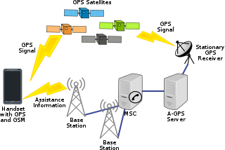
Assisted GNSS (A-GNSS) is a GNSS augmentation system that often significantly improves the startup performance—i.e., time-to-first-fix (TTFF)—of a global navigation satellite system (GNSS). A-GNSS works by providing the necessary data to the device via a radio network instead of the slow satellite link, essentially "warming up" the receiver for a fix. When applied to GPS, it is known as assisted GPS or augmented GPS. Other local names include A-GANSS for Galileo and A-Beidou for BeiDou.

A satellite navigation or satnav system is a system that uses satellites to provide autonomous geopositioning. A satellite navigation system with global coverage is termed global navigation satellite system (GNSS). As of 2024, four global systems are operational: the United States's Global Positioning System (GPS), Russia's Global Navigation Satellite System (GLONASS), China's BeiDou Navigation Satellite System (BDS), and the European Union's Galileo.

Differential Global Positioning Systems (DGPSs) supplement and enhance the positional data available from global navigation satellite systems (GNSSs). A DGPS can increase accuracy of positional data by about a thousandfold, from approximately 15 metres (49 ft) to 1–3 centimetres.

Real-time kinematic positioning (RTK) is the application of surveying to correct for common errors in current satellite navigation (GNSS) systems. It uses measurements of the phase of the signal's carrier wave in addition to the information content of the signal and relies on a single reference station or interpolated virtual station to provide real-time corrections, providing up to centimetre-level accuracy. With reference to GPS in particular, the system is commonly referred to as carrier-phase enhancement, or CPGPS. It has applications in land surveying, hydrographic surveying, and in unmanned aerial vehicle navigation.
GIOVE, or Galileo In-Orbit Validation Element, is the name for two satellites built for the European Space Agency (ESA) to test technology in orbit for the Galileo positioning system.

GNSS reflectometry involves making measurements from the reflections from the Earth of navigation signals from Global Navigation Satellite Systems such as GPS. The idea of using reflected GNSS signals for earth observation was first proposed in 1993 by Martin-Neira. It was also investigated by researchers at NASA Langley Research Center and is also known as GPS reflectometry.
Augmentation of a global navigation satellite system (GNSS) is a method of improving the navigation system's attributes, such as precision, reliability, and availability, through the integration of external information into the calculation process. There are many such systems in place, and they are generally named or described based on how the GNSS sensor receives the external information. Some systems transmit additional information about sources of error, others provide direct measurements of how much the signal was off in the past, while a third group provides additional vehicle information to be integrated in the calculation process.
Global Navigation Satellite System (GNSS) receivers, using the GPS, GLONASS, Galileo or BeiDou system, are used in many applications. The first systems were developed in the 20th century, mainly to help military personnel find their way, but location awareness soon found many civilian applications.

A satellite navigation device or satnav device, also known as a satellite navigation receiver or satnav receiver or simply a GPS device, is a user equipment that uses satellites of the Global Positioning System (GPS) or similar global navigation satellite systems (GNSS). A satnav device can determine the user's geographic coordinates and may display the geographical position on a map and offer routing directions.

The UNSW School of Surveying and Geospatial Engineering (SAGE), part of the UNSW Faculty of Engineering, was founded in 1970 and disestablished in 2013.
A software GNSS receiver is a Global Navigation Satellite System (GNSS) receiver that has been designed and implemented using software-defined radio.
Precise Point Positioning (PPP) is a global navigation satellite system (GNSS) positioning method that calculates very precise positions, with errors as small as a few centimeters under good conditions. PPP is a combination of several relatively sophisticated GNSS position refinement techniques that can be used with near-consumer-grade hardware to yield near-survey-grade results. PPP uses a single GNSS receiver, unlike standard RTK methods, which use a temporarily fixed base receiver in the field as well as a relatively nearby mobile receiver. PPP methods overlap somewhat with DGNSS positioning methods, which use permanent reference stations to quantify systemic errors.
The United Kingdom Global Navigation Satellite System was a United Kingdom Space Agency (UKSA) research programme which, between May 2018 and September 2020, developed outline proposals for a United Kingdom (UK) owned and operated conventional satellite navigation system, as a British alternative to the European Union (EU) owned and operated Galileo Global Navigation Satellite System. The main reason was to provide a national and independent system, to ensure UK security following its withdrawal from the EU as a result of Brexit. It was fully supported by the Ministry of Defence.
RTCM SC-104 is a communication protocol for sending differential GPS (DGPS) to a GPS receiver from a secondary source like a radio receiver. The standard is named for the Special Committee 104 of the Radio Technical Commission for Maritime Services (RTCM) that created it. The format does not define the source of the messages and has been used with systems as varied as longwave marine radio, communications satellite broadcasts, and internet distribution.
References
- ↑ Teunissen, Peter; Montenbruck, Oliver (2017). Springer Handbook of Global Navigation Satellite Systems. Springer. p. 1209. ISBN 9783319429281 . Retrieved 30 May 2019.
- ↑ Bossler, John D.; Campbell, James B.; McMaster, Robert B.; Rizos, Chris (2010). Manual of Geospatial Science and Technology. CRC Press. p. 231. ISBN 9781420087345 . Retrieved 30 May 2019.
- ↑ "RINEX The Receiver Independent Exchange Format Version 3.02, page 38" (PDF). International GNSS Service (IGS). 18 October 2014. Archived from the original (PDF) on 16 October 2021. Retrieved 30 May 2019.
- ↑ El-Rabbany, Ahmed (2006). Introduction to GPS: The Global Positioning System. Artech House. p. 107. ISBN 9781596930162 . Retrieved 30 May 2019.
- ↑ "RINEX The Receiver Independent Exchange Format Version 4.02, page 55" (PDF). International GNSS Service. Retrieved 2024-10-15.
- ↑ Hatanaka, Yuki (2008). "A Compression Format and Tools for GNSS Observation Data" (PDF). Bulletin of the Geographical Survey Institute . 55: 21–30. Retrieved 2020-09-25.