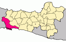
Rajapolah is a district in Tasikmalaya Regency in the Province of West Java, Indonesia. The district is well known for its handicrafts. Rajapolah is one of the most important districts in Tasikmalaya Regency, both economically and culturally.
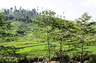
Rajapolah is situated in the middle of the drainage basin of northwestern Tasikmalaya Regency. The district lies in a relatively low-laying ground at average height of 450 m and surrounded by Galunggung highlands to the west and Sawal highlands to the east. The land of the district is mainly a gently inclined area as it slopes down from the west towards the east exit channel of the basin of the Citanduy River.
Located 17km northeast of Tasikmalaya Regency's capital Singaparna, the district comprises an area of 16.9204km2, consists of 6.5917km2 of dryland and 10.3287km2 of wetland. It borders with Jamanis District to the north, and borders with Ciamis Regency to the east as it lined with Citanduy River. On the south, Rajapolah is bounded by Cisayong District, and on the west is bounded by Sukahening District.[1]
Governance
The district of Rajapolah is divided into 8 villages.[1]
Manggungjaya
Tanjungpura
Sukaraja
Rajapolah
Dawagung
Manggungsari
Rajamandala
Sukanagalih
Culture
A picture taken from a handicraft shop in Rajapolah Handicraft Centre in Rajapolah Subdistrict
The people of Rajapolah District, estimated population of 51,524 in mid 2023,[2] are noted for their traditional works, the handicrafts. They produced a wide range area of crafts, from decorative items such as wall hangings, rugs, jewelry boxes, picture frames, to functional goods, like baskets, bags, mats, racks, plates, sandals, and cushions. Their products are exported worldwide, mainly to the U.S., Europe, and some of Asia regions. Most of the artisans created their works traditionally with their hands through weaving, plaiting, and coiling, and commonly using simple and traditional equipment. Their creations are mainly made from natural materials, such as wood, bamboo, reed, cane (rattan), rush, water hyacinth, sisal fibre, ash-wood splints, jute cord, absorbent paper, pandan, mendong (straw), and other natural materials.
Notes and references
1 2 "Rajapolah" (in Indonesian). Tasikmalaya Regency Government. Retrieved 18 January 2011.{{cite web}}: External link in |authorlink= (help)
↑ Badan Pusat Statistik, Jakarta, 28 February 2024, Kabupaten Tasikmalaya Dalam Angka 2024 (Katalog-BPS 1102001.3206)
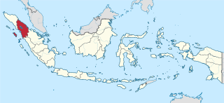
West Java is a province of Indonesia on the western part of the island of Java, with its provincial capital in Bandung. West Java is bordered by the province of Banten and the country's capital region of Jakarta to the west, the Java Sea to the north, the province of Central Java to the east and the Indian Ocean to the south. With Banten, this province is the native homeland of the Sundanese people, the second-largest ethnic group in Indonesia.
North Sumatra is a province of Indonesia located in the northern part of the island of Sumatra. Its capital and largest city is Medan. It is bordered by Aceh on the northwest and Riau and West Sumatra on the southeast, with two different coastlines located on the Indian Ocean and the Strait of Malacca, and a maritime border with Malaysia to the east. North Sumatra is Indonesia's fourth most populous province after West Java, East Java, and Central Java, and the third-largest province in area on the island of Sumatra after South Sumatra and Riau provinces. It covers an area of 72,460.74 km2, which is approximately the same size as Sierra Leone or Scotland or Maine.
West Kalimantan is a province of Indonesia. It is one of five Indonesian provinces comprising Kalimantan, the Indonesian part of the island of Borneo. Its capital and largest city is Pontianak. It is bordered by East Kalimantan and Central Kalimantan to the east, the Malaysian state of Sarawak to the north, and the Pacific Ocean to the west and the Java Sea to the south. The province has an area of 147,307 km2, and had a population of 4,395,983 at the 2010 Census and 5,414,390 at the 2020 Census; the official estimate as at mid 2022 was 5,541,376. Ethnic groups include the Dayak, Malay, Chinese, Javanese, Bugis, and Madurese. The borders of West Kalimantan roughly trace the mountain ranges surrounding the vast watershed of the Kapuas River, which drains most of the province. The province shares land borders with Central Kalimantan to the southeast, East Kalimantan to the east, and the Malaysian territory of Sarawak to the north.
Central Kalimantan is a province of Indonesia. It is one of five provinces in Kalimantan, the Indonesian part of Borneo. It is bordered by West Kalimantan to the west, South Kalimantan and East Kalimantan to the east, Java Sea to the south and is separated narrowly from North Kalimantan and Malaysia by East Kalimantan's Mahakam Ulu Regency. Its provincial capital is Palangka Raya and in 2010 its population was over 2.2 million, while the 2020 Census showed a total of almost 2.67 million; the official estimate as at mid 2022 was 2,741,075.
Lampung, officially the Province of Lampung, is a province of Indonesia. It is located on the southern tip of the island of Sumatra. It has a short border with the province of Bengkulu to the northwest, and a longer border with the province of South Sumatra to the north, as well a maritime border with the province of Banten and Jakarta to the east. It is the original home of the Lampung people, who speak their own language, and possess their own written script. Its capital is Bandar Lampung.
Garut Regency is a Regency in the West Java province of Indonesia. It covers an area of 3,065.19 km2 (1,186.91 mi2). Geographically, it lies between 6°57′34″ – 7°44′57″ South latitude and 107°24′34″ – 108°7′34″ East longitude. The population at the 2010 census was 2,404,121, and at the 2020 census was 2,585,607; the official estimate as at mid 2023 was 2,683,665. South Tarogong is the regency seat.
Cilacap Regency is a regency in the southwestern part of Central Java province in Indonesia. Its capital is the town of Cilacap.
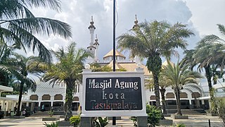
Tasikmalaya is a landlocked city in West Java, Indonesia. The city is sometimes dubbed kota santri or "the City of a Thousand Pesantrens" for its abundance of Islamic boarding schools. Located around 120 kilometres (75 mi) southeast from the provincial capital of Bandung, Tasikmalaya is passed by Indonesian National Route 3.
Zomba District is one of twelve districts in the Southern Region of Malawi, surrounded by the districts of Chiradzulu, Blantyre, Mulanje, Phalombe, Machinga, Balaka and the Republic of Mozambique to the east. The total land area is 2,363 km2, representing three percent of the total land area of Malawi. The capital is Zomba.
Ciamis is a district and a town; it is the location of the regency seat of Ciamis Regency in West Java, Indonesia. It covers an area of 33.85 km2 and had a population of 93,744 at the 2010 Census and 98,610 at the 2020 Census; the official estimate as of mid-2022 was 99,750.
Tulungagung Regency is a regency (kabupaten) of East Java Province, Indonesia. It covers an area of 1,144.53 km2 and had a population of 990,159 at the 2010 Census and 1,089,775 at the 2020 Census; the official estimate as of mid-2022 was 1,105,337. The administrative headquarters is in the town of Tulungagung.
Bogor Regency is a landlocked regency (kabupaten) of West Java province in Indonesia, situated south of DKI Jakarta. Covering an area of 2,991.78 km2, it is considered a bedroom community for Jakarta, and was home to 5,427,068 people at the 2020 census. The official estimate as at mid 2023 was 5,627,071. The town of Cibinong serves as the regency seat.
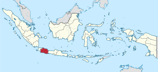
Tasikmalaya Regency is a regency in the province of West Java in Indonesia. With an area of 2,708.82 km2 (1,046 sq mi), it is the biggest and most important in the southeast region of East Preanger. Tasikmalaya Regency had a population of 1,687,776 at the 2010 census and 1,865,203 at the 2020 census; the mid-2023 official estimate was 1,907,045.
Bontang is a city on the eastern coast of the island of Borneo in Indonesia, in the province of East Kalimantan. It occupies an area of 161.88 km2 (62.50 sq mi), and the population was 140,787 at the 2010 census, and 178,917 at the 2020 census; the official estimate as of mid-2022 was 183,161. It is also the third most densely populated place in the province after Balikpapan and Samarinda.
Kampung Naga is a traditional Sundanese hamlet located in the Neglasari Village area of Salawu district in Tasikmalaya Regency, West Java Province, Indonesia.
Parahyangan or Priangan is a cultural and mountainous region in West Java province on the Indonesian island of Java. Covering a little less than one-sixth of Java, it is the heartland of Sundanese people and their culture. It is bordered to the West by Banten province, to the North by the northern coast region of Subang, Cirebon, and Indramayu, to the east by Central Java province, and to the south by the Indian Ocean.
The topography of Pakistan is divided into seven geographic areas: the northern highlands, the Indus River plain, the desert areas, the Pothohar Plateau, Balochistan Plateau, Salt Range, and the Sistan Basin. All the rivers of Pakistan, i.e. Sindh, Ravi River, Chenab River, Jhelum River, and Sutlej River, originate from the Himalayas mountain range. Some geographers designate Plateau as to the west of the imaginary southwest line; and the Indus Plain lies to the east of that line.
Raja Ampat Regency is a regency of Southwest Papua Province of Indonesia. The regency, which was formed by separating the archipelago from Sorong Regency, based on the Law 26 of 2002, was inaugurated on 12 April 2003. It consists of a number of groups of islands situated off the north-west end of West Papua; the four main islands from south to north are Misool, Salawati, Batanta, and Waigeo. At present, the regency covers a land area of 7,559.60 km2, with a total area stated as 67,379.61 km2. It had a population of 42,508 at the 2010 Census and 64,141 at the 2020 Census; the official estimate as at mid 2022 was 66,839. The principal town lies at Waisai on Waigeo Island.
Ci Tanduy is a river in the island of Java, Indonesia, about 270 km to the southeast of the capital Jakarta. It flows from West Java to Central Java province, exiting through the Bay of Citanduy to the Indian Ocean, forming a delta called "Muara Citanduy."
Ci Kaengan is a river in the island of Java, Indonesia, that flows mainly in the Garut Regency of West Java province, about 210 km to the southeast of the capital Jakarta.
This page is based on this Wikipedia article Text is available under the CC BY-SA 4.0 license; additional terms may apply. Images, videos and audio are available under their respective licenses.