Related Research Articles

The Andaman and Nicobar Islands is a union territory of India consisting of 571 islands, of which 37 are inhabited, at the junction of the Bay of Bengal and the Andaman Sea. The territory is about 150 km (93 mi) north of Aceh in Indonesia and separated from Thailand and Myanmar by the Andaman Sea. It comprises two island groups, the Andaman Islands (partly) and the Nicobar Islands, separated by the 150 km wide Ten Degree Channel, with the Andaman islands to the north of this latitude, and the Nicobar islands to the south. The Andaman Sea lies to the east and the Bay of Bengal to the west. The island chains are thought to be a submerged extension of the Arakan Mountains.

North Andaman Island is the northern island of Great Andaman of the Andaman Islands. It belongs to the North and Middle Andaman administrative district, part of the Indian union territory of Andaman and Nicobar Islands. the island is lying 137 km (85 mi) north from Port Blair.
Diglipur is the largest town of North Andaman Island, in the Andaman Archipelago, India. It is located on the southern side of Aerial Bay, at 43 metres above sea level, 298 kilometres north of Port Blair. It is crossed by the Kalpong River, the only river of the Andaman islands. Saddle Peak, the highest point in the archipelago, lies about 10 km to the south. Diglipur is also a county (tehsil) of the North and Middle Andaman District of the Andaman and Nicobar Islands union territory. Its area is 884 km2, and its population was 42,877 people as of 2001.
Narcondam, India's easternmost island, is a small volcanic island located in the northern Andaman Sea. The island's peak rises to 710 m above mean sea level, and it is formed of andesite. It is part of the Andaman Islands, the main body of which lie approximately 74 km (46 mi) to the west.The island is part of the Indian union territory of Andaman and Nicobar Islands. The island is small, covering an area of approximately 7.6 square kilometres. It was classified as a dormant volcano by the Geological Survey of India.
North and Middle Andaman district is one of the 3 districts of the Indian Union Territory of Andaman and Nicobar Islands located in the Bay of Bengal. Mayabunder town is the district headquarters. The area covered by this district is 3251.85 km2.
Saddle Peak or Saddle Hill is located on North Andaman Island in India's Andaman and Nicobar Islands. At 732 m, it is the highest point of the archipelago in the Bay of Bengal.
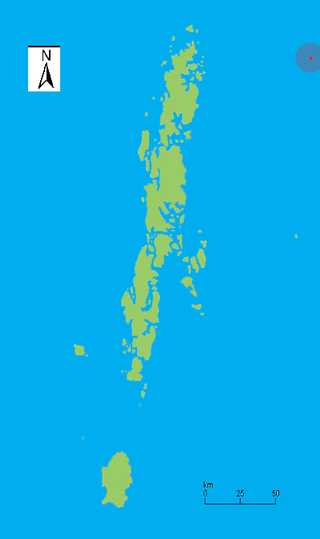
Shibpur is a village located on North Andaman Island of the Andaman & Nicobar Islands in India. Administratively, it is a part of Diglipur tehsil of North and Middle Andaman district.
Landfall Island is the northernmost island of the Indian union territory of Andaman and Nicobar Islands. It belongs to the territory's North and Middle Andaman administrative district. The island lies 220 km (137 mi) north of Port Blair, and is situated 300 km (186 mi) south of Myanmar. It is home to the Kari tribe.
Kamorta Island is an island in the Nicobar Islands chain of India, located in the northeast Indian Ocean between the Bay of Bengal and the Andaman Sea.
East Island is an island of the Andaman Islands. It belongs to the North and Middle Andaman administrative district, part of the Indian union territory of Andaman and Nicobar Islands. The island is located 220 km (137 mi) north from Port Blair.
West Island is an island of the Andaman Islands. It belongs to the North and Middle Andaman administrative district, part of the Indian union territory of Andaman and Nicobar Islands. The island lies 212 km (132 mi) north from Port Blair.
Smith Island is an island of the Andaman Islands. It belongs to the North and Middle Andaman administrative district, part of the Indian union territory of Andaman and Nicobar Islands. The island lies 298 km (185 mi) north of Port Blair.
Ross Island is an island of the Andaman Islands. It belongs to the North and Middle Andaman administrative district, part of the Indian union territory of Andaman and Nicobar Islands. the island is lying 184 km (114 mi) north from Port Blair.
Curlew Island is an island of the Andaman Islands. It belongs to the North and Middle Andaman administrative district, part of the Indian union territory of Andaman and Nicobar Islands. The island lies 150 km (93 mi) north of Port Blair.
Stewart Island is an island of the Andaman Islands. It belongs to the North and Middle Andaman administrative district, part of the Indian union territory of Andaman and Nicobar Islands. The island lies 150 km (93 mi) north of Port Blair. Its population only consists of two people.
Sound Island is an island of the Andaman Islands. It belongs to the North and Middle Andaman administrative district, part of the Indian union territory of Andaman and Nicobar Islands. The island lies 144 km (89 mi) north from Port Blair.
Swamp Island is an island of the Andaman Islands. It belongs to the North and Middle Andaman administrative district, part of the Indian union territory of Andaman and Nicobar Islands. The island lies 140 km (87 mi) north from Port Blair.
Karlo Island is an island of the Andaman Islands. It belongs to the North and Middle Andaman administrative district, part of the Indian union territory of Andaman and Nicobar Islands. The island lies 142 km (88 mi) north from Port Blair.
Khudirampur is a village in Diglipur, North Andaman Islands.
References
- ↑ Government of India (2011), Andaman and Nicobar Islands Statistical Hand-Book - North and Middle Andaman, 2007-08 To 2009-10
13°04′55″N93°00′34″E / 13.0820°N 93.0094°E
| | This Andaman and Nicobar Islands location article is a stub. You can help Wikipedia by expanding it. |