Rangat

Last updated

Rangat
village
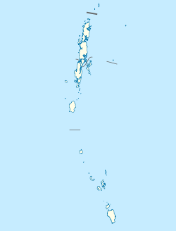
India Andaman and Nicobar Islands location map.svg
Red pog.svg
Rangat
Location in Andaman and Nicobar Islands, India
India location map.svg
Red pog.svg
Rangat
Rangat (India)
Coordinates: 12°30′11″N92°54′48″E / 12.50306°N 92.91333°E / 12.50306; 92.91333
CountryFlag of India.svg  India
Union Territory Andaman and Nicobar Administration Banner.png Andaman and Nicobar Islands
District Andaman
Population
  Total38,824 (2,001 census)
Languages
  Official Hindi, English
Time zone UTC+5:30 (IST)
PIN
744205
Telephone code03192
Nearest cityPort Blair
Climate Am
Website and.nic.in

Rangat is a town on the Middle Andaman Island, Andaman Archipelago. It is also one of the three counties ( tehsils ) administrative divisions of the North and Middle Andaman district, in the Andaman and Nicobar Islands union territory of India. Its population, according to the 2001 Census of India, was 38,824 people, mainly of Bengalis and Tamils.

Contents

Rangat is 210 km from Port Blair and 70 km south of Mayabunder. The town is well connected by road and sea routes. [1]
Tourism

The town has been described as a "ramshackle sprawl around two rows of chai shops and general stores divided by the ATR Andaman Trunk Road." [2] Some nearby tourist attractions are Amkunj Beach (8 km away) Dhani Nallah located at out skirts of Rangat and Cutbert Bay Beach (18 km away). The latter is an important turtle nesting ground, especially from December to February. [1]

Villages

As of July 2012, Rangat county included the following villages ( panchayats ): [3]

Jawahar Navodaya Vidyalaya

Centrally funded Jawahar Navodaya Vidyalaya, Middle Andaman for North and Middle Andaman district is located in Rangat taluk. Navodaya vidyalaya is well connected via National Highway 4 which lies just 1.5 km away.

Related Research Articles

<span class="mw-page-title-main">Middle Andaman Island</span>

Middle Andaman Island is an island of the Andaman Islands. It belongs to the North and Middle Andaman administrative district, part of the Indian union territory of Andaman and Nicobar Islands.

<span class="mw-page-title-main">Havelock island</span> Island of the Andaman Islands

Swaraj Dweep, is one of the largest islands in Ritchie's Archipelago, to the east of Great Andaman within the Andaman Islands. It belongs to the South Andaman administrative district, part of the Indian union territory of Andaman and Nicobar Islands. The island is 41 km (25 mi) northeast of the capital city, Port Blair.

Indira Point, the southernmost point of India's territory, is a village in the Nicobar district at Great Nicobar Island of Andaman and Nicobar Islands in India. It is located in the Great Nicobar tehsil.

Baratang Island is an island of the Andaman Islands. It belongs to the North and Middle Andaman administrative district, part of the Indian union territory of Andaman and Nicobar Islands. The island lies 150 km (93 mi) north of Port Blair.

Diglipur is the largest town of North Andaman Island, in the Andaman Archipelago, India. It is located on the southern side of Aerial Bay, at 43 metres above sea level, 298 kilometres north of Port Blair. It is crossed by the Kalpong River, the only river of the Andaman islands. Saddle Peak, the highest point in the archipelago, lies about 10 km to the south. Diglipur is also a county (tehsil) of the North and Middle Andaman District of the Andaman and Nicobar Islands union territory. Its area is 884 km2, and its population was 42,877 people as of 2001.

Strait Island is an island of the Andaman Islands. It belongs to the North and Middle Andaman administrative district, part of the Indian union territory of Andaman and Nicobar Islands. The island lies 63 km (39 mi) north from Port Blair.

Madhupur is a panchayat village located in the Diglipur block of Andaman and Nicobar Islands in India.

Bluff Island is an island of the Andaman Islands. It belongs to the North and Middle Andaman administrative district, part of the Indian union territory of Andaman and Nicobar Islands. The island lies 64 km (40 mi) north from Port Blair.

Kadamtala is a village in the southwest part of Middle Andaman Island, Andaman Archipelago. Its postal (PIN) code is 744209.

Flat Island is an island of the Andaman Islands. It belongs to the North and Middle Andaman administrative district, part of the Indian union territory of Andaman and Nicobar Islands. the island is lying 150 km (93 mi) north from Port Blair.

Spike Island is an island of the Andaman Islands. It belongs to the North and Middle Andaman administrative district, part of the Indian union territory of Andaman and Nicobar Islands. The island lies 63 km (39 mi) north from Port Blair.

Talakaicha Island is an island of the Andaman Islands. It belongs to the North and Middle Andaman administrative district, part of the Indian union territory of Andaman and Nicobar Islands. The island lies 65 km (40 mi) north from Port Blair.

Boning Island is an island of the Andaman Islands. It belongs to the North and Middle Andaman administrative district, part of the Indian union territory of Andaman and Nicobar Islands. The island lies 67 km (42 mi) north from Port Blair.

Belle Island is an island of the Andaman Islands. It belongs to the North and Middle Andaman administrative district, part of the Indian union territory of Andaman and Nicobar Islands. The island lies 58 km (36 mi) north from Port Blair.

Long Island is an island of the Andaman Islands. It belongs to the North and Middle Andaman administrative district, part of the Indian union territory of Andaman and Nicobar Islands. The island is located 80 km (50 mi) north from Port Blair.

North Passage Island is an island of the Andaman Islands. It belongs to the North and Middle Andaman administrative district, part of the Indian union territory of Andaman and Nicobar Islands. The island lies 80 km (50 mi) north from Port Blair.

Dhani Nallah is a nature walkway and beach on the outskirts of Rangat, Middle Andaman Island, in the Andaman Islands. It is located 20 km from Rangat adjacent to Andaman trunk road (ATR). Dhani Nallah is named after a mangrove associate locally called as Dhanipatti. The wooden boardwalk meandering through mangrove creek for a distance of 713 m is the main tourist attraction for the place.

Jawahar Navodaya Vidyalaya, Middle Andaman or locally known as JNV Panchawati is a boarding, co-educational school in North and Middle Andaman district of Andaman and Nicobar Islands, a U.T. in India. JNV Panchawati is funded by the Indian Ministry of Human Resources Development and administered by Navodaya Vidyalaya Smiti, an autonomous body under the ministry. Navodaya Vidyalayas offer free education to talented children, from Class VI to XII.

Jawahar Navodaya Vidyalaya, Car Nicobar or locally known as JNV Arong is a boarding, co-educational school in Nicobar district of Andaman and Nicobar Islands, a U.T. in India. JNV Arong is funded by the Indian Ministry of Human Resources Development and administered by Navodaya Vidyalaya Smiti, an autonomous body under the ministry. Navodaya Vidyalayas offer free education to talented children, from Class VI to XII.

Jawahar Navodaya Vidyalaya, South Andaman is a boarding, co-educational school in South Andaman district of Andaman and Nicobar Islands, a U.T. in India. JNV South Andaman is funded by the Indian Ministry of Human Resources Development and administered by Navodaya Vidyalaya Smiti, an autonomous body under the ministry. Navodaya Vidyalayas offer free education to talented children, from Class VI to XII.

References

  1. 1 2 Bradnock, Robert; Bradnock, Roma (2000). South India Handbook: The Travel Guide . Footprint Travel Guides. p.  209. ISBN   978-1-900949-81-1.
  2. Abram, David; Edwards, Nick; Ford, Mike; Daniel Jacobs; Shafik Meghji (20 January 2011). The Rough Guide to India. Rough Guides. p. 940. ISBN   978-1-84836-563-6.
  3. Village Panchayat Names of Andaman and Nicobar Islands Archived 2011-10-11 at the Wayback Machine . Accessed on 2012-07-28.