Randolph Square

Last updated

Randolph Square was the name given in jest to Square No. 15 of the original L'Enfant Plan for Washington, D.C., after Andrew Ellicott had replaced Pierre (Peter) Charles L'Enfant as architect of the city, and the square was removed from the City's plan. The Randolph Square Matter was used as a euphemism for the dust up which eventually led George Washington to fire L'Enfant, and turn the design project over to Ellicott. The square would have been located near the current Shaw Library between 7th and 9th streets NW and R and S streets NW.

Contents

History

After the Revolutionary War, George Washington involved himself personally in the building of a federal capital on the Potomac River, spanning the Maryland border with Virginia. [1] After L'Enfant had served under Washington in the Revolutionary Army, Washington had hired the young architect to perform various services in New York, including converting the old city hall into Federal Hall, then the seat of Congress. [2] In 1791, Washington appointed L'Enfant to design the layout of the new capital city, and Andrew Ellicott, another revolutionary veteran, to survey the existing land on which the city would be built. [1] Also heavily involved in the planning of the capital city was Thomas Jefferson, whose image for the future capital was egalitarian and simple, even understated. [3] [4] It was the tension between Jefferson's simplistic model for the city and L'Enfant's ostentatious image of a grand capital city, as well as Jefferson's preference for Mr. Ellicott, which would lead to the downfall of L'Enfant, and Square No. 15.

Over the course of 1791–1792, L'Enfant created his plan for the city, full of symbolic design elements and sweeping vistas (see: L'Enfant Plan). Jefferson, though his humble image for the city's design contrasted strongly with the grand vision of L'Enfant, successfully coordinated the project and facilitated communication between L'Enfant, Ellicott, and Washington. [5] But as L'Enfant began to run into road blocks related to cost and just how grand he intended the new city to become, he began to lose control of the project. Washington attempted to intervene on L'Enfant's behalf, but eventually the tide had turned too far against the French architect. [6] The final straw occurred when L'Enfant invoked the power of eminent domain to demolish the partially constructed mansion of Daniel Carroll, a wealthy landholder from an even wealthier family, when the home protruded seven feet into the roadway at New Jersey Avenue SE. [6] After that, and several other missteps, Jefferson approached Ellicott privately and entreated him to improve upon L'Enfant's plan for the city, and submit what would be called the Ellicott Plan to President Washington for approval. L'Enfant was effectively removed from the project and would spend the rest of his life living off of friends, his grand vision unrealized and uncredited. [6]

The Plans and Square No. 15

Detail of L'Enfant's 1791 plan for Washington with Square No. 15 outlined in red L'Enfant Plan 1791 Square No 15.jpg
Detail of L'Enfant's 1791 plan for Washington with Square No. 15 outlined in red

L'Enfant's plan for the city included a simple grid plan, overlaid with diagonal avenues radiating from the President's House and the Capitol. Due to the large intersections created when diagonal streets met grid intersections, L'Enfant installed a number of squares and plazas (now traffic circles) to his design. Among these squares was a square bordered by 7th and 9th streets NW and by S and R streets NW. The Square, labeled "Square No. 15" on the L'Enfant map, was sliced at a perfect diagonal by Rhode Island Avenue NW. [7]

Importantly for the story of Square No. 15, L'Enfant feared that the longest avenues, especially Massachusetts and Pennsylvania, would challenge elements of his design strategy, and therefore he created small angles at the larger intersections to break up the longest avenues. [8] Among the most dramatic changes to the map, Rhode Island Avenue no longer crossed through Square No. 15 at the perfect angle that it had in the L'Enfant plan, and as such was eliminated from Washington, DC. [9] [10]

Detail of Ellicott's 1792 plan for Washington with the space where Square No. 15 would be, outlined in red Ellicott Plan 1792 Square No 15.jpg
Detail of Ellicott's 1792 plan for Washington with the space where Square No. 15 would be, outlined in red

There are various theories as to why the changes were made to the city in Ellicott's new map. In her book, Washington in Maps, Iris Miller suggests it may have been due in no small part to Ellicott's lack of vision. "Examine Elements from L'Enfant's plan that Ellicott declined to grasp. One finds that Ellicott's engravings reflect the hand and mentality of an American-trained surveyor- not a European urban artist. In L'Enfant's late-seventeenth and early-eighteenth-century France, inventive composition of loosely gridded streets and radiating diagonal avenues was perfected by Andre Le Notre based upon philosophies of Descartes, Pascal and others. These responded to variations in topography that influenced spatial perception. Ellicott's regularized application of this plan neglected to account for design illusions that enhance urbanism." [11] It cannot be ignored, however, that L'Enfant was extremely unpopular by the time Ellicott took over the project. He was known as "the crazy Frenchman," blew through his budget, made demands on officials and landowners alike, and made life generally unpleasant for many around him. [2] Ellicott had been working with L'Enfant throughout the project and was a close personal confidant of Jefferson who had become a strong critic of the architect. It is unclear, therefore, whether those small changes to the map may have been made merely out of spite, or whether the spite was merely a side dish to the Iris Miller's explanation above, but the spite gave rise to the lost square's name.

The changes between the two maps were largely subtle, and therefore the four square block missing square was one of the more noticeable changes between L'Enfant and Ellicott's plan and became something of a symbol for those who had become fed up with L'Enfant's antics, of which there were many. [7] [2] Washington mourned the removal of his friend from the position of architect of the Capital city, and therefore praise of Jefferson for his hand in removing the L'Enfant were subtle. [1] Rather than make direct reference to Jefferson, therefore, those who wished to gloat referred to the "Randolph Square" matter, referring to the disappearing square in the Ellicott Plan by the name of Jefferson's Mother, the well known Jane Randolph Jefferson. [2]

Randolph Square Today

Today, the area which would have been Randolph Square is located in the Shaw Neighborhood in Washington. The land once designated for the square includes an entry to the Shaw Metro Station and is bordered by the Shaw Public Library and Green Monster to the south.

Notes

  1. 1 2 3 Melder, Keith (1997). City of Magnificent Intentions (2d ed.). Washington, D.C. and Silver Spring, MD: Intac, Inc. p. 28. ISBN   0-913137-01-4. OCLC   38292785.
  2. 1 2 3 4 Nilsson, Dex (March 2000). The Names of Washington, D.C. (2nd ed.). Rockville, MD: Twinbrook Communications. p. 42. ISBN   0-9629170-5-2. OCLC   41645721.
  3. Miller, pp. 40-43.
  4. Seale, William (1986). The President's House, Volume 1. White House Historical Association. pp. 1–4.
  5. Miller, p. 34.
  6. 1 2 3 Miller, p. 35.
  7. 1 2 Miller, p. 37.
  8. Miller, p. 45.
  9. Miller, p. 46.
  10. Partridge, William T. (1930). National Capital Park and Planning Commission: Chart 6: L'Enfant and Ellicott plans superimposed. Washington, D.C.: Government Printing Office. p. 34. OCLC   15250016 . Retrieved 2016-12-04.{{cite book}}: |work= ignored (help) At HathiTrust Digital Library.
  11. Miller, p. 44.

Related Research Articles

<span class="mw-page-title-main">Pennsylvania Avenue</span> Street in Maryland and Washington, D.C., US

Pennsylvania Avenue is a primarily diagonal street in Washington, D.C., and Prince George's County, Maryland, that connects the United States Capitol with the White House and then crosses northwest Washington, D.C. to Georgetown. Traveling through southeast Washington from the Capitol, it enters Maryland, and becomes MD Route 4 and then MD Route 717 in Upper Marlboro, and finally Stephanie Roper Highway.

<span class="mw-page-title-main">Pierre Charles L'Enfant</span> French-American architect (1754–1825)

Pierre "Peter" Charles L'Enfant was an American-French military engineer who in 1791 designed the basic plan for Washington, D.C., the capital city of the United States. His work is known today as the L'Enfant Plan. He also inspired the street plan for Detroit, Michigan.

<span class="mw-page-title-main">Dupont Circle</span> Place in the United States

Dupont Circle is a historic roundabout park and neighborhood of Washington, D.C., located in Northwest D.C. The Dupont Circle neighborhood is bounded approximately by 16th Street NW to the east, 22nd Street NW to the west, M Street NW to the south, and Florida Avenue NW to the north. Much of the neighborhood is listed on the National Register of Historic Places. However, the local government Advisory Neighborhood Commission and the Dupont Circle Historic District have slightly different boundaries.

The Washington meridians are four meridians that were used as prime meridians in the United States which pass through Washington, D.C. The four that have been specified are:

  1. through the Capitol
  2. through the White House
  3. through the old Naval Observatory
  4. through the new Naval Observatory.
<span class="mw-page-title-main">Constitution Avenue</span> Street in the city of Washington, D.C.

Constitution Avenue is a major east–west street in the northwest and northeast quadrants of the city of Washington, D.C., in the United States. It was originally known as B Street, and its western section was greatly lengthened and widened between 1925 and 1933. It received its current name on February 26, 1931, though it was almost named Jefferson Avenue in honor of Thomas Jefferson.

<span class="mw-page-title-main">History of Washington, D.C.</span>

The history of Washington, D.C., is tied to its role as the capital of the United States. The site of the District of Columbia along the Potomac River was first selected by President George Washington. The city came under attack during the War of 1812 in an episode known as the Burning of Washington. Upon the government's return to the capital, it had to manage the reconstruction of numerous public buildings, including the White House and the United States Capitol. The McMillan Plan of 1901 helped restore and beautify the downtown core area, including establishing the National Mall, along with numerous monuments and museums.

<span class="mw-page-title-main">Andrew Ellicott</span> American surveyor

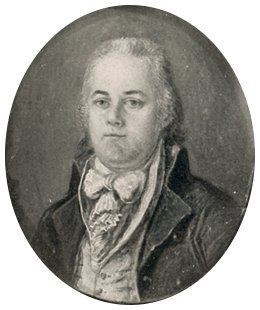
Andrew Ellicott was an American land surveyor who helped map many of the territories west of the Appalachians, surveyed the boundaries of the District of Columbia, continued and completed Pierre (Peter) Charles L'Enfant's work on the plan for Washington, D.C., and served as a teacher in survey methods for Meriwether Lewis.

<span class="mw-page-title-main">Pennsylvania Avenue National Historic Site</span> National Historic Site of the United States in Washington, D.C.

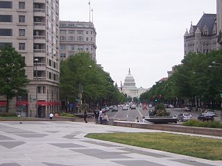
Pennsylvania Avenue National Historic Site is a National Historic Site in the city of Washington, D.C. Established on September 30, 1965, the site is roughly bounded by Constitution Avenue, 15th Street NW, F Street NW, and 3rd Street NW. The historic district includes a number of culturally, aesthetically, and historically significant structures and places, including Pennsylvania Avenue NW from the White House to the United States Capitol, the Treasury Building, Freedom Plaza, Federal Triangle, Ford's Theatre, the Old Patent Office Building, the Old Pension Office Building, which now houses the National Building Museum, Judiciary Square, and the Peace Monument.

<span class="mw-page-title-main">Rhode Island Avenue</span>

Rhode Island Avenue is a diagonal avenue in the Northwest and Northeast quadrants of Washington, D.C., and the capital's inner suburbs in Prince George's County, Maryland. Paralleling New York Avenue, Rhode Island Avenue was one of the original streets in Pierre L'Enfant's plan for the capital. It became a major commuter route, carrying U.S. Route 1 traffic into the city from Prince George's County.

<span class="mw-page-title-main">Florida Avenue</span>

Florida Avenue is a major street in Washington, D.C. It was originally named Boundary Street, because it formed the northern boundary of the Federal City under the 1791 L'Enfant Plan. With the growth of the city beyond its original borders, Boundary Street was renamed Florida Avenue in 1890.

<span class="mw-page-title-main">Jefferson Pier</span>

Jefferson Pier, Jefferson Stone, or the Jefferson Pier Stone, in Washington, D.C., marks the second prime meridian of the United States even though it was never officially recognized, either by presidential proclamation or by a resolution or act of Congress.

<span class="mw-page-title-main">Tiber Creek</span> River in District of Columbia, U.S.

Tiber Creek or Tyber Creek, originally named Goose Creek, is a tributary of the Potomac River in Washington, D.C. It was a free-flowing creek until 1815, when it was channeled to become part of the Washington City Canal. Presently, it flows under the city in tunnels, including under Constitution Avenue NW.

The streets and highways of Washington, D.C., form the core of the surface transportation infrastructure in Washington, D.C., the federal capital of the United States. Given that it is a planned city, the city's streets follow a distinctive layout and addressing scheme. There are 1,500 miles (2,400 km) of public roads in the city, of which 1,392 miles (2,240 km) are owned and maintained by city government.

<span class="mw-page-title-main">McMillan Plan</span> 1902 planning report for Washington, D.C.

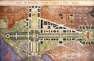
The McMillan Plan is a comprehensive planning document for the development of the monumental core and the park system of Washington, D.C., the capital of the United States. It was written in 1902 by the Senate Park Commission. The commission is popularly known as the McMillan Commission after its chairman, Senator James McMillan of Michigan.

<span class="mw-page-title-main">Downtown (Washington, D.C.)</span> United States historic place

Downtown is the central business district of Washington, D.C., located in Northwest D.C. It is the fourth largest central business district in the United States. The "Traditional Downtown" has been defined as an area roughly between Union Station in the east and 16th Street NW in the west, and between the National Mall on the south and Massachusetts Avenue on the north, including Penn Quarter. However, nowadays, Downtown D.C. usually refers to a larger area, as the DC Office of Planning states:

…most residents, workers, and visitors think of Downtown in a broader sense — including areas as far north as Dupont Circle, as far west as Foggy Bottom, and as far east as Capitol Hill. Only about half of the central city workforce is located within the city’s traditional Downtown.

Vlastimil Koubek was a Czech American architect who designed more than 100 buildings, most of them in the Washington, D.C., metropolitan area. When he died, he had designed buildings worth more than $2 billion. Most of his work is Modernist in style, although he developed a few structures in other vernaculars. He created the site plan for the redevelopment of Rosslyn, Virginia, and his Ames Center anchored the area's economic recovery. He also designed the World Building in Silver Spring, Maryland, which sparked redevelopment of that town's downtown and the L'Enfant Plaza Hotel in Washington, D.C., amongst many other buildings. In 1985, Washingtonian magazine considered him to be one of 20 people "who in the past 20 years had the greatest impact on the way we live and who forever altered the look of Washington." In 1988, The Washington Post newspaper said his Willard Hotel renovation was one of 28 projects in the area which made a signal contribution to the "feel" and look of Washington, D.C.

<span class="mw-page-title-main">Paul J. Pelz</span> American architect (1841–1918)

Paul Johannes Pelz was a German-American architect, best known as the main architect of the Library of Congress in Washington DC.

<span class="mw-page-title-main">L'Enfant Plan</span> United States historic place; street and land use plan for Washington, DC

The L'Enfant Plan for the city of Washington is the urban plan developed in 1791 by Major Pierre (Peter) Charles L'Enfant for George Washington, the first president of the United States.

<span class="mw-page-title-main">James V. Forrestal Building</span> Government office building in Washington, D.C.

The James V. Forrestal Building is a low-rise Brutalist office building in Washington, D.C. Originally known as Federal Office Building 5, and nicknamed the Little Pentagon, the Forrestal Building was constructed between 1965 and 1969 to accommodate United States armed forces personnel. It is named after James Forrestal, the first United States Secretary of Defense. It became the headquarters of the United States Department of Energy after that agency's creation in 1977.

According to accounts that began to appear during the 1960s or earlier, a substantial mythology has exaggerated the accomplishments of Benjamin Banneker (1731–1806), an African-American naturalist, mathematician, astronomer and almanac author who also worked as a surveyor and farmer.

References

Miller, Iris (2002). Washington in Maps 1606–2000 (1st ed.). New York, NY: Rizzoli International Publications Inc. ISBN   978-0-8478-2447-2. OCLC   463908485.