Related Research Articles
The Amundsen Glacier is a major Antarctic glacier, about 7 to 11 km wide and 150 km (80 nmi) long. It originates on the Antarctic Plateau where it drains the area to the south and west of Nilsen Plateau, then descends through the Queen Maud Mountains to enter the Ross Ice Shelf just west of the MacDonald Nunataks.

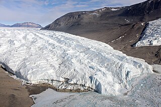
Ferrar Glacier is a glacier in Antarctica. It is about 35 nautical miles long, flowing from the plateau of Victoria Land west of the Royal Society Range to New Harbour in McMurdo Sound. The glacier makes a right (east) turn northeast of Knobhead, where it where it is apposed, i.e., joined in Siamese-twin fashion, to Taylor Glacier. From there, it continues east along the south side of Kukri Hills to New Harbor.
The Taylor Glacier is a glacier in Antarctica about 35 nautical miles long, flowing from the plateau of Victoria Land into the western end of Taylor Valley, north of the Kukri Hills. It flows to the south of the Asgard Range. The middle part of the glacier is bounded on the north by the Inland Forts and on the south by Beacon Valley.

The Wright Valley is a large east–west trending valley, formerly occupied by a glacier but now ice free except for Wright Upper Glacier at its head and Wright Lower Glacier at its mouth, in Victoria Land, Antarctica. It was named by the VUWAE (1958-59) for Sir Charles Wright, for whom the BrAE (1910-13) named the glacier at the mouth of this valley.

The Quartermain Mountains are a group of exposed mountains in Antarctica, about 20 nautical miles long, typical of ice-free features of the McMurdo Dry Valleys, Victoria Land. They are east of the Lashly Mountains, south of the Asgard Range, west of the Kukri Hills and Royal Society Range, and some distance north of the Worcester Range.
The Inland Forts are a line of peaks extending between Northwest Mountain and Saint Pauls Mountain, in the Asgard Range of Victoria Land, Antarctica. The peaks were discovered by Ervon r. Koenig and named by the British National Antarctic Expedition, 1901–04.
The Willett Range is the range extending north from Mistake Peak and running for 20 nautical miles as a high shelf along the edge of the continental ice to the Mackay Glacier, in Victoria Land. The range is breached by several glaciers flowing east from the plateau.

The Apocalypse Peaks are a group of peaks with a highest point of 2,360 metres (7,740 ft), standing east of Willett Range and between Barwick Valley and Balham Valley, in Victoria Land, Antarctica.
Balham Valley is an ice-free valley] between the Insel Range and the Apocalypse Peaks, in Victoria Land, Antarctica.
Barwick Valley is an ice-free valley north of Apocalypse Peaks, extending from Webb Glacier to Victoria Valley in Victoria Land, Antarctica. A large part of the valley has been designated an Antarctic Specially Protected Area because of its pristine condition.
The Clare Range is the range extending west-southwest from Sperm Bluff to the Willett Range on the south side of Mackay Glacier, in Victoria Land, Antarctica. It is south of the Convoy Range and north of the Olympus Range.
The Olympus Range is a primarily ice-free mountain range of Victoria Land, Antarctica, with peaks over 2,000 metres (6,600 ft) high, between Victoria Valley and McKelvey Valley on the north and Wright Valley on the south. It is south of the Clare Range and north of the Asgard Range.
The Gonville and Caius Range is a range of peaks, 1,000 to 1,500 metres high, between Mackay Glacier and Debenham Glacier in Victoria Land, Antarctica.
The McAllister Hills are a hill group or bastion between Shapeless Mountain and Wright Upper Glacier in Victoria Land, Antarctica.

Mackay Glacier is a large glacier in Victoria Land, descending eastward from the Antarctic Plateau, between the Convoy Range and Clare Range, into the southern part of Granite Harbour. It was discovered by the South magnetic pole party of the British Antarctic Expedition, 1907–09, and named for Alistair Mackay, a member of the party. The glacier's tongue is called Mackay Glacier Tongue. First mapped by the British Antarctic Expedition, 1910–13 and named for Alistair F. Mackay, a member of the party. Its mouth is south of the Evans Piedmont Glacier and the Mawson Glacier. It is north of the Wilson Piedmont Glacier and the Ferrar Glacier.
Saint Johns Range is a crescent-shaped mountain range about 20 nautical miles long, in Victoria Land, Antarctica. It is bounded on the north by the Cotton Glacier, Miller Glacier and Debenham Glacier, and on the south by Victoria Valley and the Victoria Upper Glacier and Victoria Lower Glacier.

Beadnos Nunatak is the partly ice-free hill of elevation 2190 m projecting from the ice cap west of north-central Sentinel Range in Ellsworth Mountains, Antarctica. It is named after the medieval fortress of Beadnos in Southern Bulgaria.

Opizo Peak is the mostly ice-covered peak of elevation 1137 m near the west extremity of Avroleva Heights on Brabant Island in the Palmer Archipelago, Antarctica. It has steep and partly ice-free north-northeast slopes, and surmounts Mitev Glacier to the northeast, Svetovrachene Glacier to the south and Doriones Saddle to the west-southwest.
The Cruzen Range is a mountain range that rises to 1,600 metres (5,200 ft) in Vashka Crag and extends west to east for 10 nautical miles between Salyer Ledge and Nickell Peak in the McMurdo Dry Valleys, Victoria Land, Antarctica. The range is bounded to north, east, south and west by the Clare Range, Victoria Valley, Barwick Valley, and the Webb Glacier.
Michele Eileen Raney is an American physician who was the first woman to over winter at an Antarctica inland station in 1979. Raney continued her association with the American Polar Society as a consultant, trainer and board member.
References
- ↑ "Dr. Michele E. Raney". American Polar Society. Retrieved 31 January 2016.
- ↑
 This article incorporates public domain material from "Raney Peak". Geographic Names Information System . United States Geological Survey.
| | This Victoria Land location article is a stub. You can help Wikipedia by expanding it. |