
Doda district is an administrative district of the Jammu division of Indian-administered Jammu and Kashmir in the disputed Kashmir region.
Doda is a town and a notified area committee in Doda district in the Indian union territory of Jammu and Kashmir. Doda has an average elevation of 1,107 metres (3,632 ft).

Kishtwar district is an administrative district of the Jammu division of Indian-administered Jammu and Kashmir in the disputed Kashmir region. As of 2011, it is the largest and the least populous district of Jammu and Kashmir.

Jonaicha Khurd is a village of Neemrana tehsil and the Alwar district in Rajasthan state, India, with a population around 3,000. [[Khurd and Kalan]|Khurd and Kalan] are Persian language words which mean small and big respectively. When two villages have the same name then one is distinguished as Kalan (big) and the other Khurd (small) with the village name.
Dhar Kalan is a village and administrative headquarter of Dhar Kalan tehsil in Pathankot district of Punjab State, India. It is located about 30 kilometres (19 mi) from district headquarter Pathankot and 260 kilometres (160 mi) from state capital Chandigarh. The village is administrated by Sarpanch an elected representative of the village.
Wagoora is a tehsil and a small town in Baramulla district of Jammu and Kashmir, India. Its pincode is 193109. It is located about 20 kilometres from District headquarter Baramulla, 13 kilometres from famous apple town Sopore and 49 kilometres from Srinagar, the summer capital of Kashmir. It is known for its production of apples. The population of Wagoora town is more than 2829 as per 2011 census and a literacy rate of 71.29%. Wagoora town, which was given the Tehsil status recently in the year 2013 is a Block Headquarter and is thus a centre of socio-economic and political-social needs of this vast area of Ningli region of North Kashmir. Ningli is a tributary of Jhelum River and is the main source of irrigation and drinking water to Wagoora tehsil and the only source of water to several villages of Kreeri tehsil and especially Kreeri which are devoid of water resources. Besides Ningli a distributory of Ningli viz. Khalri also plays its part in irrigating a vast area of agricultural land of the town.
Oranda is a village located in the Gurudijhatia Block of the Athagad Tehsil of the Cuttack District of the Indian state of Odisha.

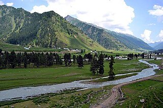
Thathri is a town and a notified area committee in Doda district in the Indian union territory of Jammu and Kashmir. Thathri valley is located in the foothills of the Himalayan mountains, about 85 km from Batote. Apart from having ample forests, the town contains many small streams flowing through its various parts. It is located on the banks of the Chenab River and the town area is spread over 1.50 sq. Km².
Doda Sodagar is a village in Sultanpur Lodhi tehsil in Kapurthala district of Punjab, India. It is located 35 kilometres (22 mi) from the city of Sultanpur Lodhi, 10 kilometres (6.2 mi) away from district headquarter Kapurthala. The village is administrated by a Sarpanch who is an elected representative of village as per the constitution of India and Panchayati raj (India).
The Warwan Valley is a Himalayan sub-valley and a tehsil in Kishtwar District in the Jammu division in union territory of Jammu and Kashmir in India. The Valley lies 68 kilometres (42 mi) northeast of Kishtwar and 136 kilometres (85 mi) from Srinagar, the summer capital of Jammu and Kashmir.
Narbal is a tehsil, block and a town in central Kashmir's Beerwah sub-district. It is also a block in Budgam district in the Indian administered union territory of Jammu and Kashmir. It is 18 km (11 mi) away from sub-district headquarter Beerwah and 13 km (8.1 mi) away from Srinagar, the summer capital of Jammu and Kashmir.

Jai Valley is an enchanting valley located 32 kilometres (20 mi) northeast of Bhaderwah town in Jammu and Kashmir, India. The Bhaderwah-Jai road, which passes through the corniferous deodar forests of Nakshri, Balote, Bhalara and Chinta Valley connects the valley with the Bhaderwah town. The valley has green meadows which act as the attraction for tourists in summers and the snow-covered landscape during winters. Jai valley has about 9 kilometres (5.6 mi) long meadows, bisected by a stream called Jai Nallah which merges with a tributary of river Chenab at Kahara in tehsil Thathri. It is also known by the names Jai Garh and Jai Top. The valley is also connected through a 37 kilometres (23 mi) long road with Gandoh. There is no Mobile Network in this valley.
Chinta Valley is a valley and a village located 20 kilometres (12 mi) northeast of Bhaderwah town on Bhaderwah-Jai road. It is covered with thick coniferous forests from all sides with a stream flowing through it known as Chinta Nallah. A village called Thuba divides the valley from Bhaderwah.
Lal Draman is a hill station in Indian union territory of Jammu and Kashmir. It is located at a distance of 25 kilometres (16 mi) north from Doda town near Sazan village, covered with lofty deodar and fir trees. A Grameen-cum-Tourism Mela is organised every year in Lal Draman, depicting the cultural programs of Doda district. Thousand of tourists visits there to enjoy this mela. In 2013, construction of roads started in rural areas including Lal Draman. As of 2020, there is only one 23 kilometres (14 mi) road northwest from Doda town towards Bijarni village and a 3 kilometres (1.9 mi) north by foot from Bijarni to reach the Lal Draman.

Bhalessa is a geographical area within Doda district in the Jammu region of India-administered Kashmir. It consists of the Bunjwah and Bhalessa Valleys, and comprises the three Tehsils of Kahara, Chilly Pingal and Gandoh.

Kahara is a village and tehsil in Doda district, Jammu, India. It is situated between mountainous cliffs 13 kilometres (8.1 mi) from Thathri on the Thathri-Gandoh road.
Donadi is a village in Kahara tehsil of Doda district in the Indian union territory of Jammu and Kashmir. It is famous for a hydroelectric power project called Lower Kalnie Power Project Donadi.
Chilly Pingal or Chilly Pingle is a tehsil of Doda district in the union territory of Jammu and Kashmir. The Headquarter of the Tehsil is Located at Tandla village.
Phagsoo is a village and tehsil in the Doda district of the Jammu division of Jammu and Kashmir, India. It was previously part of the Thathri tehsil.
Halaran is a village and panchayat located in the Kahara tehsil of Doda district in the Indian administered union territory of Jammu and Kashmir. The village is situated approximately 13 kilometers away from the sub-divisional headquarters, Thathri, and 43 kilometers away from the district headquarters, Doda.
