Rapp Creek (Tinicum Creek)

Last updated
Rapp Creek
USA Pennsylvania location map.svg
Red pog.svg
Rapp Creek
Other name(s) Rapp Run
Country United States
State Pennsylvania
County Bucks County
Township Nockamixon Township
Physical characteristics
Main source Pond
Pond near Lake Warren
530 feet (160 m)
40°32′36″N75°09′26″W / 40.54333°N 75.15722°W / 40.54333; -75.15722
River mouth Confluence of Rapp Creek and Beaver Creek forming the headwaters of Tinicum Creek
240 feet (73 m)
40°28′50″N75°08′48″W / 40.48056°N 75.14667°W / 40.48056; -75.14667
Length 5.71 miles (9.19 km)
Basin features
Progression Rapp Creek-Tinicum Creek-Delaware River
River system Delaware River
Basin size 6.97 square miles (18.1 km2)
Waterbodies Lake Warren
Bridges Lake Warren Road, Lonely Cottage Road, Colonial Way, Marienstein Road, Beaver Run Road, Quarry Road, Bunker Hill Road, Clay Ridge Road

Rapp Creek is a tributary of Tinicum Creek in Nockamixon Township, Bucks County, Pennsylvania in the United States. Rapp Creek is part of the Delaware River watershed.

Tributary stream or river that flows into a main stem river or lake

A tributary or affluent is a stream or river that flows into a larger stream or main stem river or a lake. A tributary does not flow directly into a sea or ocean. Tributaries and the main stem river drain the surrounding drainage basin of its surface water and groundwater, leading the water out into an ocean.

Tinicum Creek (Delaware River)

Tinicum Creek is a tributary of the Delaware River in Tinicum Township, Bucks County, Pennsylvania in the United States.

Nockamixon Township, Bucks County, Pennsylvania Township in Pennsylvania, United States

Nockamixon Township is a township in Bucks County, Pennsylvania, United States. The population was 3,441 at the 2010 census.

Contents

Statistics

Rapp Creek was entered into the Geographic Names Information System on 2 August 1979 as identification number 1184658. It appears in the Pennsylvania Gazatteer of Streams as identification number 03235 which indicates that Rapp Creek has a watershed of 6.97 square miles (18.1 km2). Rapp Creek and Beaver Creek meet their confluences together at Tinicum Creek's 6.40 river mile. [1] [2]

Drainage basin Area of land where precipitation collects and drains off into a common outlet

A drainage basin is any area of land where precipitation collects and drains off into a common outlet, such as into a river, bay, or other body of water. The drainage basin includes all the surface water from rain runoff, snowmelt, and nearby streams that run downslope towards the shared outlet, as well as the groundwater underneath the earth's surface. Drainage basins connect into other drainage basins at lower elevations in a hierarchical pattern, with smaller sub-drainage basins, which in turn drain into another common outlet.

Beaver Creek (Tinicum Creek)

Beaver Creek is a tributary of Tinicum Creek in Bridgeton, Nockamixon, and Tinicum Townships in Bucks County, Pennsylvania, in the United States. The creek is part of the Delaware River watershed.

River mile

In the United States, a river mile is a measure of distance in miles along a river from its mouth. River mile numbers begin at zero and increase further upstream. The corresponding metric unit using kilometers is the river kilometer. They are analogous to vehicle roadway mile markers, except that river miles are rarely marked on the physical river; instead they are marked on navigation charts, and topographic maps. Riverfront properties are sometimes partially legally described by their river mile.

Course

The headwaters of Rapp Creek rises from an unnamed pond south of Coffman Hill in upper Bucks County and flows into Lake Warren within a few hundred feet. Lake Warren was formed as a result of an earthen dam about 1935 and is owned by the Pennsylvania Fish and Game Commission. The dam is about 10 feet high, 110 feet long which allows Warren to contain a surface area of 15 acres (6.1 ha). After Lake Warren, Rapp continues generally southeastward for about two-thirds of its length receiving a tributary from the left. Then as it turns to flow to the southeast, it picks up a tributary from the right bank next to a quarry. After a short length it meets Beaver Creek to form Tinicum Creek. [1]


Geology

Appalachian Mountains mountain range in the eastern United States and Canada

The Appalachian Mountains, often called the Appalachians, are a system of mountains in eastern North America. The Appalachians first formed roughly 480 million years ago during the Ordovician Period. They once reached elevations similar to those of the Alps and the Rocky Mountains before experiencing natural erosion. The Appalachian chain is a barrier to east–west travel, as it forms a series of alternating ridgelines and valleys oriented in opposition to most highways and railroads running east–west.

Piedmont (United States) plateau region located in the eastern United States

The Piedmont is a plateau region located in the Eastern United States. It sits between the Atlantic coastal plain and the main Appalachian Mountains, stretching from New Jersey in the north to central Alabama in the south. The Piedmont Province is a physiographic province of the larger Appalachian division which consists of the Gettysburg-Newark Lowlands, the Piedmont Upland and the Piedmont Lowlands sections.

Geology of Pennsylvania

The Geology of Pennsylvania consists of six distinct physiographic provinces, three of which are subdivided into different sections. Each province has its own economic advantages and geologic hazards and plays an important role in shaping everyday life in the state. They are: the Atlantic Coastal Plain Province, the Piedmont Province, the New England Province, the Ridge and Valley Province, the Appalachian Plateau Province, and the Central Lowlands Province.

Rapp Creek begins in a region of diabase, an igneous intrusion rising during the Jurassic and the Triassic which consists of dark and very fine grained labradorite and augite. It then flows into the Lockatong Formation, a sedimentary layer consisting of dark-gray to black argillite, shale, with some limestone and calcareous shale. Shortly before it meets the Tinicum, it passes into the Brunswick Formation, which consists of sedimentary mudstone, siltstone, and shale. Mineralogy includes argillite and hornfels. [3]

Crossings and Bridges

Crossing NBI Number Length Lanes Spans Material/Design Built Reconstructed LatitudeLongitude
Clay Ridge Road756717 metres (56 ft)12Steel stringer/multi-beam or girder1917-40°28'54.3"N75°8'49.2"W
Bunker Hill Road---------
Quarry Road757316 metres (52 ft)12Masonry Arch-deck--40°29'49.9"N75°9'56.4"W
Beaver Run Road756324 metres (79 ft)21Masonry Arch-deck1902196340°30'44.8"N75°9'13.3"W
Marienstein Road---------
Colonial Way---------
Lonely Cottage Road76257 metres (23 ft)21Steel stringer/multi-beam or girder1960-40°31'58.9"N75°9'14.5"W
Lake Warren Road---------

See also

Related Research Articles

Tohickon Creek river in the United States of America

Tohickon Creek is a 29.5-mile-long (47.5 km) tributary of the Delaware River. Located entirely in Bucks County, in southeastern Pennsylvania, it rises in Springfield Township and has its confluence with the Delaware at Point Pleasant. It is dammed to form Lake Nockamixon.

Neshaminy Creek river in the United States of America

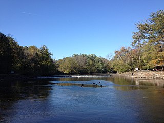
Neshaminy Creek is a 40.7-mile-long (65.5 km) stream that runs entirely through Bucks County, Pennsylvania, rising south of the borough of Chalfont, where its north and west branches join. Neshaminy Creek flows southeast toward Bristol Township and Bensalem Township to its confluence with the Delaware River. The name "Neshaminy" originates with the Lenni Lenape and is thought to mean "place where we drink twice". This phenomenon refers to a section of the creek known as the Neshaminy Palisades, where the course of the water slows and changes direction at almost a right angle, nearly forcing the water back upon itself. These palisades are located in Dark Hollow Park, operated by the county, and are flanked by Warwick Township to the south and Buckingham Township to the north.

Cabin Run (Tohickon Creek, Delaware River) tributary of Tohickon Creek in Bucks County, Pennsylvania


Cabin Run is a tributary of the Tohickon Creek in Bucks County, Pennsylvania, rising in the southwestern portion of Bedminster Township to its confluence with the Tohickon Creek in northeastern Plumstead Township. Its course is approximately 4.5 miles (7.2 km)

Newtown Creek (Neshaminy Creek tributary)


Newtown Creek is a tributary, rising near Stoop Road in Newtown Township, Bucks County, Pennsylvania, United States. It is part of the Delaware River watershed and is located entirely in Bucks County, Pennsylvania. The Newtown Creek Bridge over Centre Avenue was added to the National Register of Historic Places in 1988.

Mill Creek (Neshaminy Creek tributary, Wrightstown Township)


Mill Creek is a tributary of Neshaminy Creek, one of three tributaries of the Neshaminy which all share the same name, and one of six in Bucks County, Pennsylvania which share the name. The Geographic Name Information System I.D. is 1181118, U.S. Department of the Interior Geological Survey I.D. is 02596.

Robin Run


Robin Run is a tributary of Mill Creek, rising in Buckingham Township, Bucks County, Pennsylvania flows generally southeast to its confluence with Mill Creek in Wrightstown Township. The Geographic Name Information System I.D. is 1185219, U.S. Department of the Interior Geological Survey I.D. is 02598.

Little Neshaminy Creek river in Bucks County, United States of America - Geonames ID = 5198454

Little Neshaminy Creek is a tributary of the Neshaminy Creek, part of the Delaware River Watershed rising near the intersection of U.S. Route 202 and Pennsylvania Route 309 near Montgomeryville, Pennsylvania and meets its confluence with Neshaminy Creek at the Neshaminy's 24.10 River mile.

Pine Run (North Branch Neshaminy Creek)

Pine Run is a tributary of the North Branch Neshaminy Creek, part of the Delaware River watershed. Pine Run flows entirely in Bucks County, Pennsylvania, rising in Plumstead Township, passing through Buckingham Township and New Britain Township, meeting its confluence with the North Branch in the Borough of Chalfont.

Geddes Run (Tohickon Creek)

Geddes Run is a tributary of the Tohickon Creek contained wholly within Plumstead Township, Bucks County, Pennsylvania, in the United States.

Deer Run (Tohickon Creek)

Deer Run is a tributary of the Tohickon Creek in Bedminster Township, Bucks County, Pennsylvania in the United States.

Mink Run (Tohickon Creek)


Mink Run is a tributary of the Tohickon Creek in Bedminster Township, Bucks County, Pennsylvania in the United States.

Haycock Creek (Tohickon Creek)

Haycock Creek is a tributary of the Tohickon Creek in Bucks County, Pennsylvania in the United States and is part of the Delaware River watershed.

Threemile Run (Tohickon Creek)

Threemile Run is a tributary of the Tohickon Creek in Bucks County, Pennsylvania in the United States and is part of the Delaware River watershed.

Dimple Creek (Tohickon Creek)

Dimple Creek is a tributary of the Tohickon Creek in Haycock Township, Bucks County, Pennsylvania in the United States. It is part of the Delaware River watershed.

Beaver Run (Tohickon Creek)

Beaver Run is a tributary of the Tohickon Creek in Milford Township and Richland Township, Bucks County, Pennsylvania in the United States and is part of the Delaware River watershed.

Swamp Creek (Delaware River)

Swamp Creek is a tributary of the Delaware River in Tinicum Township, Bucks County, Pennsylvania in the United States.

Falls Creek (Delaware River)

Falls Creek is a tributary of the Delaware River wholly contained in Bridgeton Township, Bucks County, Pennsylvania in the United States. The creek boasts the highest falls in Bucks County.

Gallows Run (Delaware River)

Gallows Run is a tributary of the Delaware River in Springfield and Nockamixon Townships, in Bucks County, Pennsylvania in the United States.

References

  1. 1 2 "GNIS Feature Search". TNM download. U.S. Geological Survey, U.S. Department of the Interior. Retrieved 15 January 2018.
  2. http://www.lycoming.edu/cwi/pdfs/paGazetterOfStreams.pdf
  3. "Pennsylvania Geological Survey". PaGEODE. Pennsylvania Department of Conservation and Natural Resources. Retrieved 10 December 2017.