
The South Central Railway is one of the 19 zones of Indian Railways. The jurisdiction of the zone is spread over the states of Telangana, Maharashtra, Karnataka, Andhra Pradesh. It has three divisions under its administration, which include Secunderabad, Hyderabad, Vijayawada, Guntur, Guntakal and Nanded. Secunderabad, Telangana is the Zonal headquarter

Rayalaseema is a geographic region in the Indian state of Andhra Pradesh. It comprises four southern districts of the State, from prior to the districts reorganisation in 2022, namely Kurnool, Anantapur, YSR, and Chittoor. Four new districts were created from these, namely Sri Sathya Sai, Nandyal, Annamayya, and Tirupati. As of 2011 census of India, the western four districts of the region had a population of 15,184,908 and cover an area of 77,424 km2 (29,894 sq mi).

Penna is a river of southern India. This is a unique river in world where after originating from Nandi hills, it flows as two different streams, one in North and South directions. The Penna rises in the Nandi Hills in Chikkaballapur District of Karnataka state, and runs north and east through the states of Karnataka and Andhra Pradesh to empty into bay of bengal in Andhra Pradesh. It is 597 kilometres (371 mi) long, with a drainage basin covering 55,213 km2: 6,937 km2 in Karnataka and 48,276 km2 in Andhra Pradesh. Along with this main stream there is another stream south towards Tamilnadu with the name Then Pennai or south Pennar which further moves towards the east to empty into the Bay of Bengal.The Penna river basin lies in the rain shadow region of Eastern Ghats and receives 500 mm average rainfall annually.

Kalyandurg is a town in Anantapur district of the Indian state of Andhra Pradesh. It is the headquarters for Kalyandurg mandal and Kalyandurg revenue division. The discovery of diamond-bearing Kimberlites in Kalyandurg area, is one of the clusters that has been discovered.

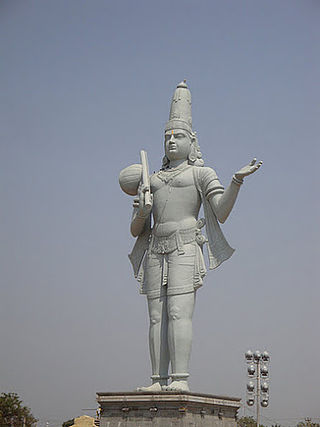
Tirupati is a city in the Indian state of Andhra Pradesh. It is the administrative headquarters of the Tirupati district. The city is home to the important Hindu shrine of Tirumala Venkateshwara Temple and other historic temples. It is located at a distance of 150 km from Chennai, 250 km from Bangalore, 406 km from Amaravati. It is one of the eight Svayam vyakta kshetras dedicated to Vishnu. Tirupati is a municipal corporation and the headquarters of Tirupati (urban) mandal, Tirupati (rural) mandal, and the Tirupati revenue division.

Chittoor district is one of the eight districts in the Rayalaseema region of the Indian state of Andhra Pradesh. It had a population of 18,72,951 at the 2011 census of India. It is a major market centre for mangoes, grains, sugarcane, and peanuts. The district headquarters is at Chittoor City.

Anantapur district, officially Anantapuramu district, is one of the eight districts in the Rayalaseema region of the Indian state of Andhra Pradesh. The district headquarters is located in Anantapur city. It is one of the driest places in South India. In the year 2022, as part of re-organisation of districts, Sri Sathya Sai district was carved out.
Kadiri is a major city in Sri Sathya Sai District the Indian state of Andhra Pradesh. It is a Special Grade Municipal City Council and headquarters of Kadiri Mandal and Kadiri Revenue Division. Kadiri Taluka ('Tehsil') was the largest taluk in the state of Andhra Pradesh when there was taluka system in Andhra Pradesh Kadiri is known for its jasmine and saffron flowers. Kadiri saffron is widely sold in Andhra and Karnataka. The Sri Lakshmi Narasimhaswamy Temple is reminiscent of Kadiri to the people of Karnataka, Telangana And Tamil Nadu. The name of Kadiri has also some interesting past. The habitation was initially named as Khadripuram as ‘khadara’ plants were largely found in the surrounding forests and Khadri has later transformed as Kadiri.

Hindupuram is a city in Sri Sathya Sai district of the Indian state of Andhra Pradesh. It is located to the edge of the Andhra–Karnataka border and is the headquarters of Hindupuram mandalam. Hindupuram is the Parliamentary Constituency in the newly formed District Sri Sathya Sai. It is located about 67 km from district headquarters Puttaparthi, 100 km from Bengaluru the capital of Karnataka, 95 km From Kadiri.
Pavagada or Pamukonda is a taluk in the Tumkur district in Karnataka, India. Historically it was part of the Mysore kingdom. Though it is geographically connected to Chitradurga district inside state of Karnataka, it comes under Tumkur district. It is 157.8 km from state capital of Bengaluru. Uttara Pinakini river flows into this Taluk. Pavagada Taluk falls on the border of Karnataka, hence a majority of the population are bilingual speaking Kannada and Telugu. The town is famous for its fort located on the hill, Kote Anjaneya temple at the foothills and also the temple of Sri Shani Mahatma.

Rayadurgam is a town in Anantapur District in the Indian state of Andhra Pradesh. It is governed by a municipal council. Rayadurgam is known for its production of textile goods and textile manufacturing industry. Rayadurgam is in Southern India about 451.6 km (280.6 mi) from Hyderabad. Rayadurgam is now slowly developing with proper transportation, modern amenities. Rayadurgam is well connected with other cities in Andhra Pradesh and Karnataka through well infrastructure of NH 544DD Highway. The nearest airport is Ballari Airport in Karnataka followed by Kurnool, Puttaparthi and Bengaluru. Rayadurgam also has a train station with major stations nearby such as Ballari, Guntakal, Gooty & Anantapur.

Guntur Railway Division is one of the six divisions of the South Central Railway zone of Indian Railways. The division was sanctioned in 1995–96 and was fully operational on 1 April 2003, with its headquarters at Guntur. The Rail Vikas Bhavan in Pattabhipuram area of Guntur, serves as the office of Divisional Railway Manager. The present divisional manager is M. Ramakrishna.
Sri City or Satyavedu Reserve Infracity Pvt. Ltd. is an integrated business city (township) and special economic zone located in Tirupati district in the state of Andhra Pradesh, India.

Dharmavaram railway station is the primary railway station serving Dharmavaram, Anantapur district. It is one of the major train junctions in Andhra Pradesh. The station comes under the jurisdiction of Guntakal division of South Coast Railways. The station has five platforms.

Kadapa–Bangalore section is an ongoing broad-gauge railway line project in the Indian states of Andhra Pradesh and Karnataka. It connects Kadapa in Andhra Pradesh with Bangalore in Karnataka via Kolar.
Rayadurg Junction railway station is the primary railway station serving Rayadurg town in the Indian state of Andhra Pradesh. The station comes under the jurisdiction of Hubli railway division of South Western Railway zone. A new railway line connecting with Kalyandurg of Anantapur district was commissioned recently. It will be eventually extended to Tumkur.
South Coast Railway Zone (SCoR) has been announced as the newest railway zone of the Indian Railways and is headquartered at Visakhapatnam, Andhra Pradesh. The formal notification for operationalization of this Zone is yet to be issued.

Kadiri railway station is a station in Anantapur district, Andhra Pradesh, India, serving Kadiri city. It lies on the Dharmavaram–Pakala branch line and comes under the jurisdiction of Guntakal railway division of the South Central Railway zone. The railway line was constructed in 1891 along with the Railway Station and electrified in 2020. The Platforms are well sheltered when compared with other stations in same Railway line. It is the major railway station in the railway line.
Annamayya district is one of the eight districts in the Rayalaseema region of Andhra Pradesh, established in 2022. Rayachoti is the district administrative headquarters, and Madanapalle is the most populated city in the district.

Sri Sathya Sai district is a district in the Indian state of Andhra Pradesh. Its headquarters is at Puttaparthi. It was formed on 4 April 2022 from parts of the erstwhile Anantapur district.