
Brisbane is the capital of and the most populated city in the Australian state of Queensland, and the third most populous city in Australia. Brisbane's metropolitan area has a population of over 2.5 million, and the South East Queensland metropolitan region, centred on Brisbane, encompasses a population of more than 3.6 million. The Brisbane central business district stands on the historic European settlement and is situated inside a peninsula of the Brisbane River, about 15 kilometres from its mouth at Moreton Bay, a bay of the Coral Sea. The metropolitan area extends in all directions along the hilly floodplain of the Brisbane River Valley between Moreton Bay and the Taylor and D'Aguilar mountain ranges. It sprawls across several of Australia's most populous local government areas (LGAs)—most centrally the City of Brisbane, which is by far the most populous LGA in the nation. The demonym of Brisbane is "Brisbanite", whilst common nicknames include "Brissy", "River City" and "Brisvegas".

Ipswich is an urban region in Brisbane, Australia. Situated on the Bremer River, it is approximately 40 kilometres (25 mi) west of the Brisbane central business district. A local government area, the City of Ipswich has a population of 200,000. The city is renowned for its architectural, natural and cultural heritage. Ipswich preserves and operates from many of its historical buildings, with more than 6000 heritage-listed sites and over 500 parks. Ipswich began in 1827 as a mining settlement.

Ipswich railway station is located on the Main line in Queensland, Australia. It serves the urban centre of Ipswich.

Rosewood is a small town and locality in the Bremer Valley, Queensland, Australia. It is within the local government area of City of Ipswich.

The City of Ipswich is a local government area in Queensland, Australia, located in the southwest of the Brisbane metropolitan area, including the urban area surrounding the city of Ipswich and surrounding rural areas.

North Ipswich is a suburb Ipswich in the City of Ipswich, Queensland, Australia. Raymonds Hill is a neighbourhood within the suburb of North Ipswich. In the 2016 census, North Ipswich had a population of 4,515 people.

North Tivoli is a suburb of Ipswich in the City of Ipswich, Queensland, Australia. In the 2016 census, North Tivoli had a population of 96 people.

East Ipswich is a residential inner-city suburb of Ipswich in the City of Ipswich, Queensland, Australia. In the 2016 census, East Ipswich had a population of 2,410 people.
Brassall is a suburb in the City of Ipswich, Queensland, Australia. In the 2016 census, Brassall had a population of 10,898 people.
Karalee is a suburb in the City of Ipswich, Queensland, Australia. In the 2016 census, Karalee had a population of 4352 people.

Muirlea is a rural locality in the City of Ipswich, Queensland, Australia. In the 2016 census, Muirlea had a population of 190 people.
The Shire of Moreton was a local government area in South East Queensland, Australia, located about 50 kilometres (31 mi) southwest of Queensland's capital, Brisbane. It represented an area surrounding but not including Ipswich, and existed from 1917 until 1995, when it merged into the City of Ipswich, City of Brisbane, and Shire of Esk.
Ellen Violet Jordan was an Australian politician. She was the second woman elected to the Queensland Legislative Assembly, and the first representing the Labor Party.

The Shire of Brassall is a former local government area in the south-east of Queensland, Australia. It existed from 1879 to 1917.
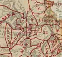
The Shire of Bundanba is a former local government area in the south-east of Queensland, Australia. It existed from 1879 to 1916.

The Shire of Walloon is a former local government area in the south-east of Queensland, Australia. Its administrative centre was in the town of Marburg.
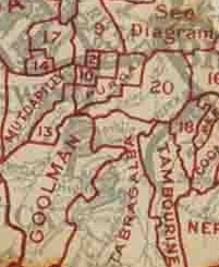
The Shire of Purga is a former local government area in the south-east of Queensland, Australia.

The Shire of Rosewood is a former local government area in the south-east of Queensland, Australia.
The Shire of Lowood is a former local government area in the south-east of Queensland, Australia. It existed between 1912 and 1916.
The Shire of Ipswich is a former local government area in the south-east of Queensland, Australia.
