
Inverness is an unincorporated community and census-designated place (CDP) in western Marin County, California, United States. It is located on the southwest shore of Tomales Bay 3.5 miles northwest of Point Reyes Station and about 40 miles (64 km) by road northwest of San Francisco, at an elevation of 43 feet. In the 2020 census, the population was 1,379. The community was named by a Scottish landowner after Inverness in Scotland.

Bethel is a town in Sussex County, Delaware, United States. According to 2010 Census Bureau figures, the population of the town is 171. It is part of the Salisbury, Maryland-Delaware Metropolitan Statistical Area.

Panama City is a city in and the county seat of Bay County, Florida, United States. Located along U.S. Highway 98 (US 98), it is the largest city between Tallahassee and Pensacola. It is the more populated city of the Panama City–Lynn Haven, Florida metropolitan statistical area. Panama City was severly damaged when Hurricane Michael made landfall as a Category 5 hurricane on October 10, 2018. As of the 2020 census, the population was 35,392, down from the figure of 36,484 at the 2010 census.

Shaftesbury is a town and civil parish in Dorset, England. It is situated on the A30 road, 20 miles west of Salisbury, near the border with Wiltshire. It is the only significant hilltop settlement in Dorset, being built about 215 metres above sea level on a greensand hill on the edge of Cranborne Chase.

Isle of Whithorn is one of the most southerly villages and seaports in Scotland, lying on the coast north east of Burrow Head, about three miles from Whithorn and about thirteen miles south of Wigtown in Dumfries and Galloway. Whithorn,, is a former royal burgh in Wigtownshire, Dumfries and Galloway, with which Isle of Whithorn is frequently incorrectly amalgamated or confused. It is referred to locally as 'The Isle' - never 'the Isle of Whithorn'.

The Dhofar Governorate is the largest of the 11 Governorates in the Sultanate of Oman in terms of area. It lies in Southern Oman, on the eastern border with Yemen's Al Mahrah Governorate. It is a rather mountainous area that covers 99,300 km2 (38,300 sq mi) and has a population of 416,458 as of the 2020 census. The largest city, as well as capital of the Governorate, is Salalah. Historically, the region was a source of frankincense. The local variety of Arabic is Dhofari Arabic, which is quite distinct from that of the rest of Oman and from Yemen.
Wilsons Promontory, is a peninsula that forms the southernmost part of the Australian mainland, located in the state of Victoria.
Salalah is the capital and largest city of the southern Omani governorate of Dhofar. Its population in 2009 was about 197,169.

The Dhofar Rebellion, also known as the Dhofar War or the Omani Civil War, was waged from 1963 to 1976 in the province of Dhofar against the Sultanate of Muscat and Oman. The war began with the formation of the Dhofar Liberation Front, a group which aimed to create an independent state in Dhofar, free from the rule of the Omani Sultan Said bin Taimur. The rebels also held the broader goals of Arab nationalism which included ending British influence in the Persian Gulf region.

State Road 922 is a 5.548 miles (8.929 km) east–west road built in 1951, passing through the cities of North Miami, Bay Harbor Islands, and Bal Harbour, Florida. Locally, the street is also known as North 125th Street, North Miami Boulevard, Northeast 123rd Street, Broad Causeway, 96th Street, and Kane Concourse. Its western terminus is an intersection with Northwest Seventh Avenue, one block west of Interstate 95, its eastern terminus is an intersection with SR A1A. The street is an important commercial artery in northeastern Miami-Dade County, with stores lining much of the route, including the Bal Harbour Shops mall near its eastern terminus.

Gairsay is a small island in Orkney, Scotland, located in the parish of Rendall, 1.5 miles (2.4 km) off the coast, astride one of the approaches to the bays of Firth and Kirkwall. It is about 2 miles (3.2 km) long and 1 mile (1.6 km) wide and includes one conical hill and a small harbour called Millburn Bay, which is sheltered by the peninsula known as the Hen of Gairsay.

Taqah is a province and coastal town in the Dhofar governorate, in southwestern Oman. It is located at about 17°2′14″N54°24′13″E.
Al-Saadah is a coastal town 30–40 km from Salalah in southern Oman. There are a few supermarkets, shops, schools and colleges in the town, as well as a police station and a healthcare centre run by the Ministry of Health. Saadha is linked to the nearby towns of Taqa, Mirbat, and Thumrait by motorable roads.

Dhofar Sports, Cultural and Social Club is an Omani sports club based in Salalah, Oman. The club is currently playing in the Oman Professional League, top division of Omani football. Their home ground is Al-Saada Stadium, but they also recognize the older Salalah Sports Complex as their home ground. Both stadiums are government owned, but they also own their own personal stadium and sports equipment, as well as their own training facilities.

Khawr Rawrī or Khor Rori is a bar-built estuary at the mouth of Wādī Darbāt in the Dhofar Governorate, Oman, near Taqah. It is a major breeding ground for birds, and used to act as an important harbour for frankincense trade when it was an open estuary. Khor Rori has been identified as the location of Moscha Limen and Abyssapolis in ancient Greek literature. The area represents a popular tourist spot within Oman and since 2000, is a part of the UNESCO World Heritage Site, the Land of Frankincense.
Abu Dhalouf is a town on the north coast of Qatar, located in the municipality of Al Shamal. It was demarcated in 1988 and is bounded by Madinat ash Shamal to the immediate east, with Ar Ru'ays located to the immediate east of Madinat ash Shamal.
Lady Franklin Bay is an Arctic waterway in Qikiqtaaluk Region, Nunavut, Canada. The bay is located in Nares Strait northwest of Judge Daly Promontory and is an inlet into the northeastern shore of Ellesmere Island.
The Port of Salalah is the largest port in Oman. Situated in the Dhofar Governorate, on the Arabian Sea which is on the northern part of the Indian Ocean, it is centrally located at the crossroads of trade between Asia and Europe. With over 2.5 billion consumers, it serves the markets of East Africa, the Red Sea, the Indian Subcontinent and the Arabian/Persian Gulf on its doorstep.

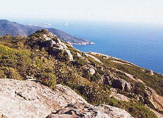
The Dhofar Mountains are a mountain range in the southeastern part of the Arabian Peninsula. In a broad sense, they extend from Dhofar Governorate in Oman to Hadhramaut Governorate in Yemen, and are located between the Hajar in the northern part of Oman, and the Sarawat in the western part of Yemen. Otherwise, the range in the eastern part of Yemen, particularly near Mukalla, is referred to as the "Hadhramaut" or "Mahrat".

Rakhyut is a Wilayat of Dhofar in the Sultanate of Oman.
