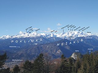
The Julian Alps are a mountain range of the Southern Limestone Alps that stretch from northeastern Italy to Slovenia, where they rise to 2,864 m at Mount Triglav, the highest peak in Slovenia and of the former Yugoslavia. A large part of the Julian Alps is included in Triglav National Park. The second highest peak of the range, the 2,755 m high Jôf di Montasio, lies in Italy.

The Zugspitze, at 2,962 m (9,718 ft) above sea level, is the highest peak of the Wetterstein Mountains as well as the highest mountain in Germany. It lies south of the town of Garmisch-Partenkirchen, and the Austria–Germany border runs over its western summit. South of the mountain is the Zugspitzplatt, a high karst plateau with numerous caves. On the flanks of the Zugspitze are three glaciers, including the two largest in Germany: the Northern Schneeferner with an area of 30.7 hectares and the Höllentalferner with an area of 24.7 hectares. The third is the Southern Schneeferner which covers 8.4 hectares.

Broad Peak is a mountain in the Karakoram on the border of Pakistan and China, the twelfth-highest mountain in the world at 8,051 metres (26,414 ft) above sea level. It was first ascended in June 1957 by Fritz Wintersteller, Marcus Schmuck, Kurt Diemberger, and Hermann Buhl of an Austrian expedition.

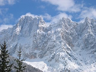
Hoher Dachstein is a strongly karstic mountain in central Austria and the second-highest mountain in the Northern Limestone Alps. It is situated at the border of Upper Austria and Styria, and is the highest point in each of those states. Parts of the massif also lie in the state of Salzburg, leading to the mountain being referred to as the Drei-Länder-Berg.

The Großer Priel is, at 2,515 metres above the Adriatic (8,251 ft), the highest mountain of the Totes Gebirge range, located in the Traunviertel region of Upper Austria. It ranks among the ultra prominent peaks of the Alps. Part of the Northern Limestone Alps, its steep Dachstein cliffs form the northeastern rim of a large karst plateau and are visible from afar across the Alpine Foreland.
Škrlatica, historically also known as Suhi plaz, is a mountain in the Slovenian Julian Alps. With its summit at 2,740m above sea level, it is the second highest peak in Slovenia and the third highest in the Julian Alps as a whole.

Glasgwm is a mountain in Gwynedd, Wales forming part of the Aran range in southern Snowdonia. It is one of the three Marilyns that make up the range, the others being Aran Fawddwy and Esgeiriau Gwynion. To the west is Maesglase and the Dyfi hills, while to the south-west lies Cadair Idris. To the south lies the Plynlimon range. It is 779 metres (2,556 ft) high.

The Gross Lohner, is a limestone mountain of the Bernese Alps, located between Adelboden and Kandersteg in the Bernese Oberland. The main summit has an elevation of 3,048.7 metres (10,002 ft) above sea level and is distinguished by the name Vorder Lohner. The mountain features several other peaks, from east to west:

Rhos Fawr is a mountain summit in the Radnor Forest, a rather isolated dome of hills to the north of the village of New Radnor. The local rocks are sedimentary shales and mudstones with some Silurian limestone. With a height of 660 metres (2,170 ft), it is the highest point in the Radnor Forest and the historic county top of Radnorshire.

The Kaiser Mountains are a mountain range in the Northern Limestone Alps and Eastern Alps. Its main ridges – are the Zahmer Kaiser and south of it the Wilder Kaiser. The mountains are situated in the Austrian province of Tyrol between the town of Kufstein and the town of St. Johann in Tirol. The Kaiser Mountains offer some of the loveliest scenery in all the Northern Limestone Alps.

Alpine club huts or simply club huts (Clubhütten) form the majority of the over 1,300 mountain huts in the Alps and are maintained by branches, or sections, of the various Alpine clubs. Although the usual English translation of Hütte is "hut", most of them are substantial buildings designed to accommodate and feed significant numbers of hikers and climbers and to withstand harsh high alpine conditions for decades.

The Fritz Pflaum Hut is an Alpine club hut belonging to the Bayerland Section of the German Alpine Club, located in the Kaisergebirge mountains in the Austrian federal state of Tyrol.

The Grutten Hut is an Alpine club hut at a height of 1620 metres in the Kaisergebirge in Tyrol in Austria. It is owned by the Turner Alps Kränzchen Section of the German Alpine Club.

The Gaudeamus Hut is an Alpine club hut in the Kaisergebirge mountains in Tyrol. It is run by the Main-Spessart section of the German Alpine Club.
Three-thousanders are mountains with a height of between 3,000 metres (9,800 ft), but less than 4,000 metres (13,000 ft) above sea level. Similar terms are commonly used for mountains of other height brackets e. g. four-thousanders or eight-thousanders. In Britain, the term may refer to mountains above 3,000 feet (910 m).

Komna is a mountain karst plateau in the Julian Alps in northwestern Slovenia. It has an elevation from 1,300 metres (4,300 ft) to 1,750 metres (5,740 ft). It has a triangular shape and rises above the Bohinj Basin. To the east, it continues into the Triglav Lakes Valley. The lowest measured temperatures in Slovenia were recorded at Komna in January 2009, reaching −49 °C (−56 °F).

Maki Yūkō, also known as Maki Aritsune, was a Japanese mountain climber.

Savica Falls is a waterfall in northwestern Slovenia. It is 78 meters (256 ft) high and is fed by a karst spring also called Savica just above the waterfall.
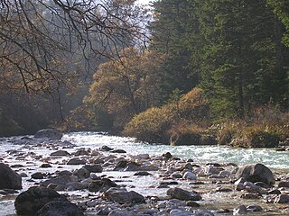
The Triglav Bistrica is a stream that flows through the glacial Vrata Valley southwest of Mojstrana, Slovenia. Its source is below the north face of Mount Triglav in the blind Bukovlje Valley, and it flows past the Aljaž Lodge. In addition to several intermittent tributaries with a flashy character, it also has three constant tributaries, all of them flowing from valleys below the east slope of Mount Škrlatica: Dry Creek, Red Creek, and Peričnik Creek. The Triglav Bistrica empties into the Sava Dolinka at Mojstrana. It falls 400 meters (1,300 ft) during its approximately 10-kilometer (6.2 mi) course.

